Good run of swell and conditions this period

Victorian Surf Forecast by Craig Brokensha (issued Monday 2nd May)
Best Days: Tuesday, protected spots Wednesday, Thursday and Friday, Sunday Surf Coast
Features of the Forecast (tl;dr)
- Mix of W/SW and SW groundswell tomorrow AM, easing through the day with strengthening N winds (tending N/NW at times on the Surf Coast)
- Building mid-period W/SW swell Wed with fresh NW tending W/NW winds, W/SW-SW mid-late PM
- Mod-large, inconsistent W/SW groundswell for Thu AM, easing slowly with W/NW tending SW winds
- Easing surf Fri with W/NW tending variable winds
- Mix of localised S/SW swell and late increase in mid-period SW swell Sat with strong W/SW-SW winds, easing Sun with W/NW tending SW winds
Recap
A slow start to the weekend with small, clean waves across the Surf Coast, better yesterday though slow with an inconsistent mix of W/SW groundswell and mid-period energy. This swell was a little tricky owing to the strongest part of the low linked to it being a touch off axis and aimed better for Western Australia and this resulted in clean but surf to mostly 3ft on the Surf Coast, 5-6ft to the east and without those possibly bigger sets.
Today has held a fun, clean 3ft on the Surf Coast with 4-5ft sets to the east under more workable N/NW winds.
This week and weekend (May 3 - 8)
The main change from Friday's update is that winds are now looking more favourable for the larger swell due mid-late week which is a plus, favouring protected breaks across the state.
Looking at tomorrow though, and later today and mix of W/SW and SW groundswell are due, peaking overnight and easing through tomorrow across all locations. The SW energy was generated by a strong, small polar low that formed south-southwest of Western Australia, with the W/SW energy produced by a front moving in under Western Australia, generating W/NW gales.
The Surf Coast should see fun 3-4ft waves tomorrow morning with 5-6ft sets to the east, easing through the day. Winds will strengthen from the N'th, tending N/NW for periods on the Surf Coast but back to the N later. So the beaches look cleanest.
Wednesday morning looks to start a touch slower but we'll see a quick increase in mid-period W/SW swell energy ahead of our larger W/SW groundswell on Thursday.
Both these swells have been generated by the same frontal progression.
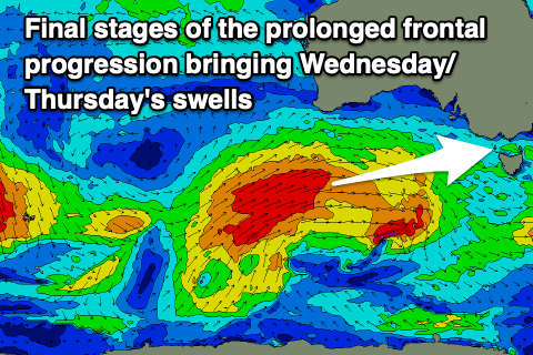 That being an intense polar low that formed in our far, far swell window late last week, west of the Heard Island region, pushing slowly east on the weekend while generating a fetch of weakening severe-gales. The progression has since projected up and under Western Australia while continuing to generate a broad fetch of W/SW gales and will weaken while tracking up into South Australia tomorrow.
This final stage of the progression will bring the mid-period energy, with building sets from 3ft on the Surf Coast and 4-6ft on the Mornington Peninsula to 4ft+ and 6ft+ respectively due Wednesday along with fresh NW tending W/NW winds ahead of a shallow W/SW-SW change mid-late afternoon.
Thursday should see a range of sizes owing to the inconsistency and westerly nature of the swell between 4-6ft on the Surf Coast magnets (smaller elsewhere) and 8ft on the sets across the Mornington Peninsula in the morning, easing through the day.
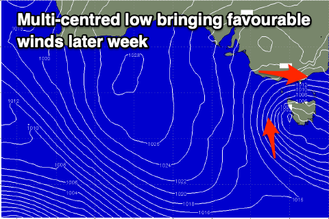 With the remnants of the frontal progression pushing up into South Australia, we'll see a broad, multi-centred low meandering slowly across us late week, bringing W/NW tending SW winds on Thursday and W/NW tending variable winds Friday as the swell continues to ease.
Come Saturday we'll finally fall under the backside of the broad low, bringing strong W/SW-SW winds (possibly W'ly on the Surf Coast in the morning) along with some new, building mid-period SW swell later in the day, peaking Sunday.
There'll also be some weak S/SW swell from the backside of the low but coming back to the mid-period energy, this will be generated by a front tracking south-west, south of Western Australia, producing strong to gale-force NW winds. Size wise we're looking at 3ft+ waves on the Surf Coast and 4-6ft sets to the east on Sunday along with favourable W/NW to SW winds.
Make the most of this run of swell as it looks like we'll see high pressure moving in, swinging winds around to the east-northeast next week with smaller swells. More on this Wednesday.
Oh! And don't forget: Tim Bonython's Australian Surf Movie Festival kicks off TOMORROW! There's ONE show only at St Kilda, and ONE show only in Geelong. He's got some incredible new 8K footage of Nazaré, Jaws, Mavericks, Teahupo’o and more, that simply HAS to be seen on the big screen. Get your tickets here: https://swllnt.com/3v2MlNc
Comments
Riddle me this. This morning was reading NNW at SC and now reading N yet it was cleaner this morning than now. If you go baywx.com, you can even see it straighten up out there. Stroke ya chin on that one
https://m.
Nothing to do with the wind, your beer goggles didn't wear off until around lunch.
hey hey, I was near angelic this weekend!
Ha, just one of those quirks of the coast eh.
"Oh! And don't forget: Tim Bonython's Australian Surf Movie Festival kicks off TOMORROW!"
See you all @ the Village Twin. Just like the Pix Theatre only the screen's a bit bigger, the lights are brighter and the carpet stickier. I'll be the one in the Golden Breed T, Woollen Beanie, Ugg boots and Starsky Jacket.
My car has died just when the surf is finally improving :-0
New SW groundswell is looking solid. Long lines.
Yeah it was ay. Did the afterwork with the grom and there was one moment where we got caught inside and worked hard.
I should read the notes, thought it would be smaller than yesterday.
Today was a cracker day all day, got 3 sessions in. Helps with a few less on it, yesterday was a circus at a lot of spots
Just goes to show
Locals score with no tourists
Happy days
Reef I surfed was really busy yesterday and today in the morning. Todays arvo sesh was a different story and was pretty bloody good..
Cant wait for that Northerly to do its ‘quirk’ today.
I vote we call it a POST
Piece
Of
Sh!7
Tendency
It only needs to be a slight degree towards west from north and over 15 Knots and ya feathers will be ruffled long slong.
Your not wrong.
Checked it a 7. Clean as whistle. Check now and its easily NNW if not NW. It’s barely changed direction at SC. Fucking joke
And what have you learnt, never trust SC.
Reckon SC is just not calibrated correctly?
Or maybe there's a physical feature of the island which blocks a direct NNW flow, and makes it read as a N.
On a separate note, never really understood why NNW, which visually looks more offshore for the peninsula does more damage than a SSE.
Kind of Like how a NNE on the surf coast is worse than a WSW I guess.
Nah. Just 5-10 degrees makes a world of difference.
As for the seperate note, hard to say but a SE is definitely better here knot for knot. Winds blowing into rights aren’t that bad over here at all. Can’t say why it would be different over yonder..
How about just go surf instead of over thinking weather
Get out there !!!
I did.
Take the compass down to clock the actual degrees?
Yes. It was similar to this -
https://m.
Haha
Holeyyyyy crap Saturday is going to go right off!!!