Fun surf for the beaches, new swell on the weekend

Victorian Surf Forecast by Craig Brokensha (issued Monday 25th April)
Best Days: Exposed beaches tomorrow morning and Wednesday morning, Sunday Surf Coast, Monday morning Surf Coast, next Tuesday and Wednesday mornings
Features of the Forecast (tl;dr)
- Fading mid-period S/SW swell tomorrow, slowed slighty by a reinforcing pulse for the PM
- Light N tending SE winds on the Surf Coast, NE tending SE to the east
- Similar winds Wed with fading surf
- Mod-fresh N/NE winds Thu as the swell bottoms out
- Strong N/NE tending S/SW winds mid-late PM
- Moderate-large W/SW groundswell building later Sat with W/NW tending W/SW-SW winds, peaking Sun with W/NW tending variable winds
- Easing surf Mon with W/NW tending SW winds
- Inconsistent W/SW groundswell for Tue PM, peaking Wed with variable tending S winds
Recap
Plenty of surf over the weekend though a little bumpy on the Surf Coast with winds out of the south-east, cleaner for periods to the east.
Yesterday afternoon a mix of inconsistent SW groundswell and mid-period S/SW swell filled in, with both still in the mix today with 3-4ft sets on the Surf Coast and 4-6ft waves to the east, cleanest on the beaches.
This week and weekend (Apr 26 – May 1)
Down, down, down.
We've got great conditions for the beaches and easing swell over the coming days, best tomorrow and small but still fun Wednesday.
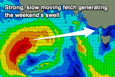
The downwards trend will be thanks to a strong, slow moving blocking high that's been keeping swell generating storms at arms length, deflecting away from us.
This will see mostly mid-period swell energy on the fade, easing from 2-3ft on the Surf Coast magnets and 4ft+ to the east. There's one final pulse of small, reinforcing mid-period S/SW swell due tomorrow and this should maintain 2ft+ sets on the Surf Coast into the afternoon with 3-4ft sets to the east, easing from 2ft and 3ft respectively Wednesday morning.
Winds look favourable for both coasts tomorrow, light from the N on the Surf Coast and NE to the east ahead of SE sea breezes.
Similar winds are due on Wednesday, with the exposed beaches being the pick.
 Strengthening mid-latitude frontal activity moving in from Western Australia will result in freshening N/NE winds on Thursday, stronger Friday ahead of an afternoon S/SW change.
Swell wise the surf will bottom out Thursday and Friday morning.
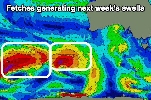
Looking at the westerly swell due off the mid-latitude frontal activity and besides a small to tiny, flukey pulse Friday afternoon and with the onshore change, a better pulse of W/SW groundswell is due Saturday afternoon, generated by a strong polar turn mid-latitude front firing up south-west of Western Australia Wednesday evening. A fetch of slow moving W/SW gales will generate a moderate to large sized swell, with it due to build strongly into the afternoon, likely peaking Sunday morning.
Sets to 3-4ft should be seen by dark Saturday on the Surf Coast, 6ft to the east, with 4-5ft sets Sunday on the Surf Coast and 6-8ft waves to the east.
 Winds will be favourable for the Surf Coast and W/NW Saturday morning ahead of the swell, W/SW-SW into the afternoon with great conditions Sunday with W/NW tending variable winds.
Easing surf with W/NW winds is due on Monday ahead of a new, inconsistent W/SW groundswell due later Tuesday/Wednesday. The source of this swell and following pulses with be strong storms firing up south-west of Western Australia, and it looks like winds will be favourable and light ahead of S'ly breezes late week. We'll have a closer look at this Wednesday.
Comments
The Bureau of Meteorology (BOM) says the La Niña system will likely ease by "late Autumn or early winter" however forecasters in the US paint a different story.
They monitored sea surface temperature and air pressure difference between Tahiti and Darwin to develop the forecast. La Niña has a 59 percent chance of continuing through the Southern Hemisphere's winter and a 50 to 55 percent chance of persisting thorough the Southern Hemisphere's spring," Weatherzone said, referring to forecasts from US National Weather Service's Climate Prediction Centre (CPC) and Columbia University's International Research Institute for Climate and Society (IRI).
Can I tap out?
Looks like a developing warm Kelvin wave will kill off the chance for a three-peat next summer.
Still the signal will linger into winter mixed with the negative IOD so wetter than normal winter and likely more mid-latitude systems before resetting into next summer.
Sunday next weekend and Monday morning next week look like it will be worth a paddle somewhere
:-)
Morning Craig, I randomly received this article in my news feed this morning, probably need to take it with a grain of salt but what are your thoughts?
https://www.dailymail.co.uk/news/article-10749843/amp/Six-MONTHS-Austral...
There’s a simple solution WAG
Do tell?
A house (preferably on stilts) on the east coast of Australia. You just need to be prepared for crowds and some bad attitudes like Winki x 10 (or more) However there are waves everywhere and everyday. Plenty to go round :)
Alternatively Ciloms Airport Lodge @ Tullamarine
Haven't felt the need to go to the pool ruckus, I like being out in nature, that's surfing's main drawcard. Great waves are such a distant memory, its gotta change soon.........
I hear ya! Had the odd session here or there but happy to leave that synthetic computer game simulation to others.
It certainly is one hell of a dogs breakfast down there… don’t think they could have made it any uglier if they tried. Nothing was really considered beyond the machine and 2 concrete bodies of water.
To be honest while it wasn’t a 6 month period to write home about have had plenty of waves and surprisingly of quality so can’t complain in the slightest. Often you just need to travel a little further, hike through a forest or take a long walk in nature which is a positive rather than a negative. The road less travelled
Hope you get plenty whenever they arrive
Yeah, cheers mate, you too. Looking forward to getting back out there soon as my collarbone heals.
Wow what a terrible article. Just slap-dash but the point is still valid.
Yes La Niña still has a strangle-hold on the Pacific and this will continue to influence or weather and rainfall into winter.
There's the Indian Ocean Dipole though which plays a greater part in our rainfall through winter and spring, with this due to be strong negative, ie much warmer than normal water off our North West and under Indonesia.
The negative IOD usually coincides with La Niña and this will bring higher than normal rainfall to most of the country thanks to the moisture being dragged south-east across us.
Forecasts look to finally break down the Niña pattern into our summer (50/50 chance) , but by then it'll nearly be three years under its influence. We'll see.
Wow! Three years. I thought I was just getting old 'n cynical, like the old "yousta be better back in my day". It really has been an overall forgettable surf period for us Southerners.
looks good for sunday Craigos. I take it you are seeing more energy than what is on the charts? eg Torquay is calling 3ft (arguably 4ft on magnets) you are seeing 4-5ft?
I'd be comfortable with 3-5ft at this stage with that west direction.
Thanks mate appreciate it
Craigos - how long you think the offshores will hold for on Monday?
Dunno if it's because I've been barely surfing (relatively) the last couple of years but am back into it now - but the water clarity seems suburb at the moment.
Wonder if the Easterlies kind of blow away the sediment from the surf coast area?
Might just be me, but I'm quite enjoying seeing the reflection patterns on the sand while surfing.
I was surfing on the east coast yesterday (Schanck region) and the water was as clear as I’ve seen it! We were all commenting on the fact you could see the sea bed easily and the water was crystal clear!
They say a week is a long time in politics, but it would seem a day is a long time in surf forecasting....especially where mid-latitude systems are concerned.