Workable weekend, fun on the beaches early-mid next week

Victorian Surf Forecast by Craig Brokensha (issued Friday 22nd April)
Best Days: Tomorrow, Sunday morning for the keen, Monday morning exposed beaches, Tuesday until late afternoon, next Sunday
Features of the Forecast (tl;dr)
- Easing mid-period S/SW swell tomorrow with light SE winds (possibly variable at times in the AM)
- Building mix of inconsistent SW groundswell and mid-period S/SW swell Sun with light-mod SE winds, freshening from the S/SE
- Easing mix of swells Mon with NE tending E/SE winds
- Run reinforcing mid-period S/SW swell Tue with N/NE tending late E/SE winds
- Fading surf Wed with mod-fresh N/NE tending NE winds
- Tiny Thu with strong N/NE winds
- Building moderate sized W groundswell Sat with gusty NW tending SW winds, easing Sun with N/NW tending variable winds
Recap
Poor conditions across nearly all locations yesterday with the arrival of a large, long-period SW groundswell, mixed in with some mid-period energy. Protected spots offered the cleanest options through the day working the big tidal range.
This morning we've got a drop in swell and a continuation of average to poor conditions on the Surf Coast, improving to the east with a lighter E'ly breeze but large 6ft+ sets on the beaches. The swell will continue to ease through the day as winds shift back to the S/SE.
This weekend and next week (Apr 23 – 29)
 Tomorrow looks to be the pick of the weekend as we see winds become really light from the SE, even possibly variable across some locations throughout the morning as the current swell continues to ease.
The groundswell energy will be gone, with mid-period swell dropping from a S/SW direction. Easing sets from 3ft are expected on the Surf Coast with 4ft to possibly 5ft sets to the east. That low morning tide will likely sap a bit of the energy through the morning.
Sunday looks less ideal with an early low point in swell though workable, light to moderate SE morning winds. A new, inconsistent SW groundswell is due into the afternoon, generated by a strong but distant low that fired up south-east of the Heard Island region during the middle of this week.
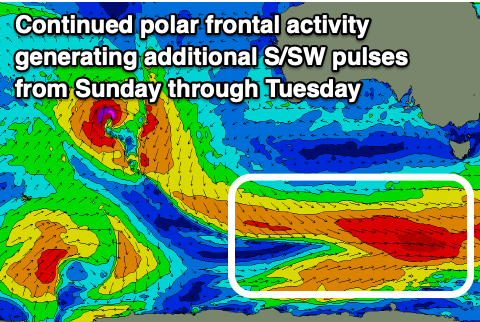
There'll be long waits for sets but the Surf Coast swell magnets should see 3ft surf, with 4-5ft waves to the east. Conditions will become bumpier though with a freshening S/SE breeze. Also in the mix should be some similar sized, slightly more consistent, mid-period S/SW swell spreading off continued polar frontal activity south-west of Tasmania today, building Sunday morning and easing Monday.
Monday morning is still looking really fun on the exposed beaches with a NE offshore and easing, inconsistent SW groundswell and mid-period S/SW swell from a similar size to Sunday afternoon. That being 3ft sets on the Surf Coast, 4-5ft to the east.
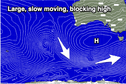
Now, as touched on the last couple of updates, a strong slow moving high will put a block across our main swell windows through the weekend and early next week, resulting in the swell bottoming out through the middle of next week.
 One final pulse of reinforcing mid-period S/SW swell is due Tuesday, generated by a final polar front generating a fetch of strong to gale-force W/NW winds over the weekend. This should keep the Surf Coast around 2ft+ with 3-4ft sets to the east under a N/NE offshore wind, tending variable ahead of late E/SE-SE sea breezes.
Wednesday looks small but clean all day with moderate to fresh N/NE tending NE winds, with the swell bottoming out Thursday under strong N/NE breezes.
Moving into the end of the week, a flurry of mid-latitude frontal activity pushing up and into Western Australia will push the high further east, bringing a NW tending SW change on Saturday, though swell wise, the high riding storm activity won't be ideal for us.
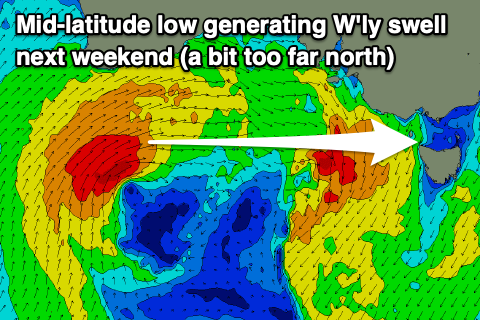 A strong and slow moving front will push up towards Western Australia and then east through the Bight but be generally too far north to generate any major swell for us.
We're due to see a moderate sized W'ly groundswell from this source for next Saturday/Sunday, with Sunday looking the pick under N/NW tending variable winds. Size wise the Surf Coast will be small and inconsistent, better across more exposed breaks but we'll have a closer look at this on Monday. Have a great weekend!
Comments
Question craig : you say "low morning tide will likely sap a bit of the energy through the morning" I thought a generally a higher tide does this on a small swell, but a low as well?