Large swell with onshore winds, improving slowly from the weekend

Victorian Surf Forecast by Craig Brokensha (issued Wednesday 20th April)
Best Days: Selected spots tomorrow, Saturday morning, Monday and Tuesday mornings on the exposed beaches
Features of the Forecast (tl;dr)
- Large SW groundswell filling in tomorrow (likely undersized early), mixed in with mid-period energy
- Mod-fresh S/SW tending lighter S/SE winds tomorrow
- Easing mix of swells Fri with moderate S/SE-SE winds
- Futher drop in swells Sat with light E/SE morning winds (possibly variable at times)
- Building mix of inconsistent SW groundswell and mid-period S/SW swell Sun PM with light-mod SE winds, freshening from the S/SE into the PM
- Easing mix of swells Mon with light NE tending E/SE winds
- Small, fading surf Tue with moderate N/NE tending E/SE winds
Recap
Monday's good pulse of SW groundswell with workable onshore winds into the afternoon was spoilt by stronger onshore breezes yesterday, with choppy poor surf easing back from the 3ft+ range on the Surf Coast, 4-5ft to the east.
This morning the surf is smaller and conditions are clean on the Surf Coast with 2ft to occasionally 3ft sets on the magnets, smaller elsewhere. We should see some new, mid-period swell energy building into this afternoon but winds will shift W/SW-SW and strengthen. There's a chance winds tip back W/NW on dark across the Surf Coast.
This week and weekend (Apr 21 – 24)
Looking at the coming days of surf and we've got a large mix of long-period SW groundswell and mid-period energy due to arrive through tomorrow, peaking during the day but with onshore winds as a high moves in behind a more defined change early tomorrow morning.
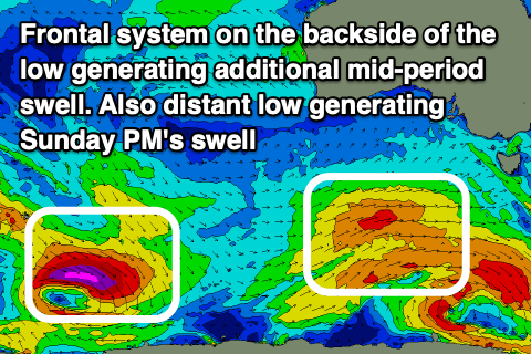
The source of these swells was a strong polar low generating a fetch of severe-gale to storm-force winds Monday and Tuesday, with a front spawning off the low bringing the wind change and additional mid-period energy.
 The Surf Coast should build to 5-6ft on the magnets with 8ft sets to the east but a moderate to fresh S/SW breeze will create average conditions, easing and tending S/SE through the day.
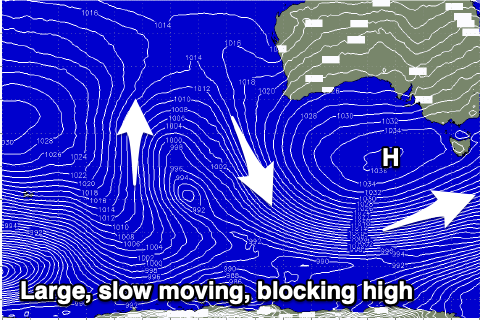
Both the SW groundswell and mid-period energy will ease into Friday, further Saturday but the size, strength and slow movement of the high pushing in from the west will keep onshore winds blowing until Monday.
We should see lighter winds develop through this period, but a moderate S/SE-SE breeze is expected on Friday with easing sets from 4-5ft on the Surf Coast swell magnets and 6ft to possibly 8ft to the east.
Saturday looks smaller and back to 3ft on the Surf Coast with easing 3-5ft surf to the east along with a lighter, workable E/SE breeze. We may see this wind tend variable at times through the morning, with the beaches being the pick.
Unfortunately light to moderate SE winds are due again into Sunday along with a new, building SW groundswell, generated by a small, distant polar low developing south-east of the Heard Island region last night. A tight fetch of severe-gale to storm-force W/NW winds are forecast with the low pushing into the polar shelf during tomorrow. There should also be some mid-period S/SW swell in the mix from a strengthening fetch of W'ly gales, south-west of Tasmania on Friday.
 Building surf to 3ft on the Surf Coast is due into the afternoon, 4-5ft to the east but with a freshening S/SE breeze, best Monday as the swells ease from a similar size under light, morning NE winds.
As the high continues to move slowly east next week, winds will persist from the north-eastern quadrant, freshening each day as a mid-latitude trough/low starts moving in through the Bight. Swell wise, the large, broad and slow moving nature will block our swell window with the surf due to bottom out into the middle of next week.
It looks like we'll see the mid-latitude frontal activity bringing some new westerly swell next weekend, but we'll have a closer look at this Friday.
Comments
I don't hate much in life but SE'sters are at the top of the list
You got a boat?
Had one several years back GF. Would often go over mid week with nobody there except us few on the boat. Still one of the best waves around when the ‘Genie gets Rubbed the right way’. Miss going there, a lot.
Nah, but I think at least 500 other surfers do. And I imagine they'll be clearing their schedules as I type...
You can drive to Right point and Flynn’s
The remaining 2000 surfers in Victoria who have taken the week off, and don't own a boat, will be heading there.
1x tide in daylight hours and draining over 6 and flooding near 5 with a shit load of humans, you can have it Goof.
Speaking of the tidal circus and also the latest talk of sharp fins and sharp noses, a mate last week had his nose sliced open at TC by his fin, needing plastic surgery, the same nose years ago was almost detached from his face by the nose of his board I think, and once I heard him squeal when the nose of his board almost popped his eye out of the socket luckily retracting back in. Maybe he should sand the trailing edge of his fins and remove the useless point on the top end of his surfboard.
Jeezus!
I think that bloke needs to find an alternative pastime... Holy Shit!
I get the feeling it may be the forces of the universe trying to balance out the surfing community's attractiveness, he is a very attractive human.
Gee's, super long period this morning
Craig. It's been a long time since I've seen energy like that in the water, was it born under Madagascar somewhere?
Na here..
But that doesn't seam far enough away for a 18-20sec period?
Swell period isn't relative to distance from the storm it's relative to the fetch strength and longevity. The stronger the winds and for a greater period of time, the larger the swell periods.
That interesting mate, I thought that the fetch X wind strength generates the initial raw ocean surface swell size. Like, the stronger the wind blows from a consistant direction and at a consistent strength, over a static part of the ocean, the larger the surface waves will be generated over that static area. If the surface storm then fizzles out, that said swells energy will continue too travel in whatever direction was related to the initial fetch and will continue too increase in period as it travels.
There will obviously be some decay/attenuation in wave height as it travels away from the original storms position due to surface friction etc but the deep water energy/period within the watercolume, between each wave, will continue grow/increase.
The perfect scenario is a captured fetch, where the storm will move at the same speed as the swell being generated within that fetch, causing the wave heights to be compounded and maintained, whist the period continues to increase over a physical distance.
That also appears be reflected in your WAMS, as the swell travels from its deep ocean source to land the wave period continues to increase, even if the wave height may attenuate over that vast ocean distance, if not being supported by a continuous wind over that entire distance.
Where have I got confused?
Agh you're close.
But swell period only grows to a maximum limit depending on how strong the core winds were.
Ie no matter how long a 25kt fetch blows for, swell periods will only reach a maximum of 8-9s, even if it travels across the globe.
Same with long-period swells, they'll grow and sort themselves out away from the storm but reach a maximum depending on how strong the core winds were and for how long. Ie they don't continue to grow indefinitely. You'll see this on the WAMs as well.
Have a read of this, you'll find it interesting..
https://www.swellnet.com/news/swellnet-dispatch/2011/04/28/why-swell-tra...
Off topic. But back in old skool days before ASCATS or whatever. Looking at a weather map, how would you work out wind strength? Ie 1000 would genearte 10knots?
You couldn't.
And, you would have needed to work out the alignment of the fetch relative to the Great Circle paths too.
Sure, you might be in the ballpark for one synoptic chart here or there, however the error margins for just 5-10kts are significant (let alone 15kts+), and these errors propagate over time (i.e. swell travel distance). Not too bad for local swell sources (i.e. East Coast) but very difficult for long range sources (Southern Ocean, Indian Ocean).
However, back in the day, surf specifics weren't as much of a factor as they are now. The main goal was to estimate whether it would be big or small, and whether the winds would be good or bad.
Ahhhh. Thanking you. Makes alot of sense, especially that last part. Rippa
Oooo that was a big set. Step ladder style. Each one bigger than the next.
Some very long lines with huge distance between them on a check this arvo. Power.