Good week of swell once winds swing offshore

Victorian Surf Forecast by Craig Brokensha (issued Monday April 11th)
Best Days: Keen surfers Wednesday, Thursday, Friday Surf Coast, Saturday beaches to the east, Sunday
Features of the Forecast (tl;dr)
- Moderate sized SW tending S/SW groundswell peaking this afternoon, easing tomorrow with moderate S'ly winds
- Mod-large S/SW groundswell building Wed PM with light-mod S/SE winds
- Easing S/SW groundswell Thu with a reinforcing SW groundswell for the PM
- Moderate N tending E winds Thu (N/NW Surf Coast in AM)
- Easing SW groundswell Fri with N/NW winds, ahead of a shallow morning change, likely variable into the PM
- Moderate sized, building mid-period SW swell Sat PM with E tending SE winds
- Easing SW swell Sun with strong N/NE tending NW winds, SW Mon
Recap
Unfortunately the small, inconsistent and slightly flukey mid-period W/SW swell due over the weekend didn’t really translate to much across the Victorian coastline. Whilst the swell performed as expected in Western Australia, it under performed in South Australia and our state, with a localised SE windswell more evident on Saturday, with the exposed beaches to the east performing best yesterday nudging to 3ft+. Conditions were great for the beaches though with peaky options on the Surf Coast.
Today a trough has brought an onshore change along with an expected spike of moderate sized SW tending S/SW groundswell. Cape Sorell has shot up and we should see the Surf Coast reaching an easy 4ft this afternoon but with those poor winds.
This week and weekend (Apr 12 - 17)
Today’s spike of groundswell was generated by a late forming low that dropped south-east through our swell window yesterday. It should reach an easy 4ft across the Surf Coast magnets with 6ft sets to the east, easing back through tomorrow from 3ft and 4ft on the sets respectively.
Unfortunately winds will remain an issue and moderate from the S, creating bumps all day.
Wednesday should see lighter S/SE winds through the morning with a temporary low point in swell ahead of a moderate to large S/SW groundswell kicking strongly into the afternoon.
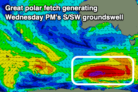 The source of this swell is a strong polar low that’s developed south of the country, with a great fetch of severe-gale to storm-force W/SW winds due to be generated through our southern swell window today before passing into the swell shadow of Tasmania tomorrow.
Size wise it looks to be a touch under Friday’s expectations, but we’ll still see the Surf Coast kicking to a strong 4-5ft (possibly rare bigger clean up on the magnets later) and 6ft to possibly 8ft to the east.
Winds will remain moderate into the afternoon creating workable conditions for the keen and experienced, with Thursday the pick as the swell eases under a N’ly offshore. Winds should tend N/NW across the Surf Coast and swell wise we’ll see the S/SW groundswell easing as some reinforcing SW groundswell arrives for the afternoon.
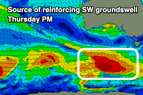 The reinforcing energy will be generated by a great polar front pushing under the country tomorrow and Wednesday evening, generating a fetch of gale to severe-gale W/NW winds.
Size wise surf to 4ft is due across the Surf Coast magnets most of the day with 6ft sets to the east, and afternoon winds are due to swing lighter E’ly.
Come Friday the reinforcing SW groundswell should ease and conditions look great with a N/NW offshore ahead of a shallow, weak SW change mid-morning that might become variable into the afternoon.
Longer term some new mid-period S/SW swell is likely into Saturday afternoon ahead of an inconsistent SW groundswell for Monday afternoon. These will be generated by secondary polar lows moving through our swell window through the middle to end of the week but not to the strength of the current activity.
Saturday afternoon’s should come in around the 4ft range on the Surf Coast and 6ft to the east, easing from a similar size Sunday with Monday’s being less consistent and similar in size.
Winds look to swing around to the E on Saturday with stronger N/NE tending N/NW winds ahead of a cold front Sunday but we’ll have a closer look at this on Wednesday.
Comments
Finally! Last weekend was pretty good as well :)
Please don't tell me the Bone sacrificed himself, I couldn't live with that....although I will enjoy the surf
maybe this is the season change
Definitely an Autumnal feel to the weather and forecast. Hope it stays that way. Hey Craig, is Friday going to be Good? (Sorry, I couldn't resist.)
Ha!
Thanks for flicking the seasonal switch Craig;)
Looks like there's a few incoming 3 to 4ft pulses and some light winds creating pretty reasonable conditions to finish off the pro. Shame we're not going to see any big solid bowl action but still looks like a great size for performance waves, especially at Winki.
Also, the latest charts are suggesting the best of it will be for the common man, we'll finally get some more solid stuff for the locals, straight after the event window, so everyone will be frothing on the timing.
Yeew!
WSL fluked it again...