More activity inbound as winds slowly relax

Victorian Surf Forecast by Craig Brokensha (issued Friday 8th April)
Best Days: Tomorrow, Sunday, Tuesday and Wednesday, Thursday morning
Features of the Forecast (tl;dr)
- Small, inconsistent mid-period W/SW swell Sat and Sun, with a similar sized SW groundswell in the Mix Sun
- Light N/NE (N/NW early Surf Coast) tending NE-E/NE winds tomorrow ahead of late sea breezes, fresh N tending variable NW Sun
- Moderate sized SW-S/SW groundswell building Mon with mod-fresh S/SE winds (possibly light dawn)
- Easing S/SW swell Tue with light SE winds
- Mod-large S/SW groundswell filling in Wed with moderate SE winds, freshening into the PM (possibly E/SE at times)
- Easing S/SW groundswell Thu with NE tending S/SE winds
- Reinforcing SW swell Fri with S winds
Recap
A junky mix of SE windswell and fading W/SW swell energy on the coast yesterday with average to poor conditions, workable for periods to the east of Melbourne.
Today the SE windswell is fading along with some very small background swell energy though conditions are cleaner on the beaches.
This weekend and next week (Apr 9 – 15)
The weekend is looking much better for a wave compared to what we've seen this week, with a mix of inconsistent swells but favourable winds for the exposed beaches and Surf Coast reefs at times.
Firstly, an inconsistent mid-period W/SW swell is due tomorrow and Sunday, generated by a healthy but not overly strong frontal progression through our distant swell window, south-west of Western Australia this week.
On Sunday an additional small SW groundswell should be in the mix, generated by a very tight low dipping south-east through our swell window yesterday, coming in around a similar size to the W/SW energy.
Sets to 2-3ft (inconsistent) are due on the Surf Coast magnets tomorrow and Sunday with 3-4ft waves to the east and the odd 5ft'er.
Winds should be light from the N/NE tomorrow morning (tending N/NW early on the Surf Coast) shifting NE-E/NE through the day ahead of weak late sea breezes.
Sunday will then see fresher N'ly winds, easing and tending N/NW early afternoon on the Surf Coast and then variable ahead of a late, weak S'ly change as a trough moves in from the east.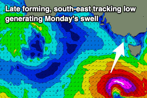
This trough will be attached to a strong, deepening low late in our swell window on Sunday, with a very brief but significant fetch of W/SW gales due to be generated through our south-west and then southern swell windows.
This will produce a short-lived spike of SW tending S/SW groundswell Monday which will build through the day and likely reach 3-4ft on the Surf Coast with 5-6ft sets on the Mornington Peninsula. Winds now look less than ideal in the wake of the trough later Sunday with moderate to fresh S/SE breezes (possibly lighter at dawn).
Winds will become lighter Tuesday but persist from the SE as the swell drops rapidly, easing from 2-3ft on the Surf Coast and 4ft+ to the east. While not ideal there'll be workable waves all day.
Looking at the outlook into the end of the week and weekend, and locally winds will remain a slight issue as a high sits south-west of us, squeezed by inland instability resulting in persistent SE winds. While not overly strong they'll create average conditions and spoil a strong pulse of new S/SW groundswell Wednesday.
 Thursday morning should offer more favourable NE winds ahead of a weak trough, back to the SE Friday and S Saturday.
Coming back to Wednesday's swell, and a significant polar low will develop south of Western Australia Sunday evening, with a great fetch of severe-gale to storm-force W/SW winds due to be generated through our southern swell window.
This will generate a moderate-large S/SW groundswell for Wednesday, peaking into the afternoon with sets to 6ft on the Surf Coast and 6-8ft to the east but with that moderate SE breeze. The swell will ease Thursday from the 4ft range on the Surf Coast and 5-6ft to the east.
A reinforcing SW swell is due Friday from a fetch of W/NW gales moving through our swell window on Tuesday and this should maintain 3-4ft waves on the Surf Coast and 5-6ft sets to the east.
Longer term there's plenty more swell on the way, it's just the local winds that we'll have to keep an eye on. More on this Monday. Have a great weekend!
Comments
Sweet! there will be something to ride for everyone over the weekend, low expectations probably the best way to approach it, that and high volume to make the most of it.
Exactly.
Swell. Swell. Swell. Not perfect but we will take it.
Huey pushed out the summer vacay by months cavorting with the Mexican mistress to the east but is back on the farm in the nick of time to fire up the trusty old westerly storm track and pump some swell out for the pros.
Now there's a god I can worship
Sat morning you could see that secondary E swell still in the water, I wondered if the whole swell was still E. Can see swell train analysis 1.4m 13.3s 239degrees. and 0.9m 6.1s 96degrees. Made for bumpy/peakiness. Extra foam used.
You surf a known break vj? How was it?
Not Bells or the pop, it was OK I guess, smaller than I was expecting (was expecting head high sets for some reason). The wind started on the glassy side then the NE got up a little, was out till about 8:45 or so.
Ill never forget but cant sure circa late 2012 or early 13. It was wither 144 or 177 degrees at double digit seconds. Could se the lines at Porto. That, and oddly enough, a light West wind cranked a novelty spot wayy up.
Love novelty angles, had very good overhead surf on NW coast of Tassie with rare events like that (NE direction there I thought). Here today, gone tomorrow.
Gotta love novelty blue moon material… There’s always waves (90% of the time anyway). You just need to know how to find them and/or sometimes do a little extra mileage
Helps if you own a helicopter
Looked rubbish on the reefs about 10.30 this morning.. as vj said an obvious mix of se and sw swell. And east winds.
It was shit. Barely any sign of a SW swell
Small over east. Mainly 2ft. Very small on the low tide.
Concur. Very little SW swell. And weak SE. Status quo.
Fingers crossed for something soon…
Yeah today's mid-period W/SW swell looked hardly evident today. Inco 3ft sets to the east.
At least it was clean in the morn I suppose.
Craig, something wrong with the SN long range?
Model data from NOAA has been unavailable (outage at their end). Should hopefuly be fixed today.
https://www.swellnet.com/forums/website-troubleshooting/537572
Thanks Ben
Wasn't terrible where I surfed this weekend (or maybe it's been terrible for too long?).
Couple of 3ft rogues, gin clear water and still in boardshorts.
Yes Stok, pleased to report a bank formed overnight on a nearby SC beach (right in front of a camera!) and the after lunch session got pounded relentlessly by waist to shoulder high lefts on a magic Sunday arvo despite Craig's mournful plee in the morning 'Might see a small pulse through the day but don't get your hopes up.' After months of nothing but winging and whining just like that all is good with the world.
Kept 2mm of rubber on though.