Improving surf as the day progresses tomorrow

Victorian Surf Forecast by Craig Brokensha (issued Friday 18th March)
Best Days: Experienced surfers, beaches to the east from mid-late morning tomorrow, Sunday morning, Monday across the exposed beaches, Tuesday for keen surfers across the exposed beaches
Features of the Forecast (tl;dr)
- Moderate sized, mid-period W/SW swell for tomorrow with strong E tending fresh E/NE winds, variable early afternoon ahead of sea breezes
- Inconsistent W/SW groundswell arriving mid-late morning Sun with light NW tending S/SW winds late AM (dawn N/NE east of Melbourne)
- Easing W/SW swell Mon with light N/NE tending S/SE winds ahead of a strong evening SW change
- Small surf Tue with variable tending S/SE winds
- Poor Wed with strong S/SW winds
Recap
A low point in swell yesterday with great conditions, onshore this morning and another lay day.
This weekend and next week (Mar 19 – 25)
After a deterioration in expected conditions in Wednesday's notes for tomorrow, we're now looking at fun waves on the beaches that can handle our new W/SW swell.
A trough moving up the NSW coast will be quickly followed by a high, swinging winds from a pre-dawn, strong E/SE breeze, to a strong E'ly at first light, easing while tending E/NE later morning and then variable ahead of mid-afternoon sea breezes.
 This will see improving conditions across the exposed beaches while the Surf Coast will remain mostly poor with a localised SE windswell in the mix with a new, mid-period W/SW swell.
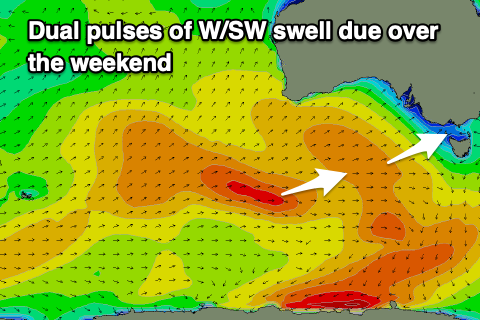
The source of the W/SW swell was a strong, elongated mid-latitude frontal progression pushing under Western Australia through the middle of the week, weakening while tracking south-east of us yesterday.
The Surf Coast should come in at 3ft on the sets (possibly odd bigger one magnets), with 4-6ft surf on the Mornington Peninsula.
A slight drop in size is due Sunday morning but our reinforcing W/SW groundswell from mid-late morning is on track, generated by a stronger but tighter fetch of W/NW gales following the mid-latitude frontal progression linked to tomorrow's swell.
It'll be less consistent but 3ft sets should persist across the Surf Coast magnets from midday into the afternoon (2-3ft early) with 2-3ft surf for the most part at other breaks, 4-5ft to the east. Winds will be light from the N/NE at dawn east of Melbourne but shifting light NW quickly, clean on the Surf Coast ahead of a shallow S/SW change late morning.
The shallow nature of the change will see winds shift back to the N/NE on Monday morning with the inconsistent groundswell easing from 2ft to possibly 3ft on the Surf Coast magnets and 4ft on the sets to the east.
Tuesday looks smaller along with morning variable winds (a day for the keen on the beaches), poor Wednesday as a trough brings a strong S/SW change.
Longer term, a small, weak mid-period SW swell is expected Thursday but some stronger polar frontal activity firing up later next week should generate some better swell for next weekend. More on this Monday. Have a great weekend!