Improving weekend across the beaches

Victorian Surf Forecast by Craig Brokensha (issued Friday 11th February)
Best Days: Mid-late morning to mid-late afternoon on the beaches tomorrow, Sunday on the beaches
Features of the Forecast (tl;dr)
- New mid-period W/SW-SW swell tomorrow with gusty E/SE winds, swinging E/NE mid-late morning and back to the E/SE later
- Building SE windswell tomorrow afternoon
- Mix of swells Sun (easing on the Surf Coast) with fresh to strong N/NE winds ahead of a late, strong SS/SW change
- Building SW groundswell Mon PM with moderate S/SW tending fresh S winds
- Peak in SW groundswell Tue AM with fresh S/SW winds
- Slowly easing surf Wed with moderate SE tending fresh S/SE winds
- Moderate sized + swell for next Fri/Sat
Recap
Clean conditions on the Surf Coast yesterday morning but tiny and full with sets to 1-1.5ft, bumpy and to 2-3ft to the east. A new pulse of mid-period W/SW swell due to fill in through the day didn't really eventuate but this morning is revealing more energy but with a moderate to fresh S'ly breeze. All in all it's not great.
This weekend and next week (Feb 12 - 18)
The weekend will provide improving surfing options across the beaches along with a mix of swells, cleanest and more organised Sunday.
We'll see a reinforcing pulse of W/SW-SW swell filling in tomorrow, generated by a healthy mid-latitude front pushing in behind the low linked to today's swell. It should provide 2ft to occasionally 3ft sets on the Surf Coast with 4ft to occasionally 5ft to the east along with improving conditions.
Early will be poor with a gusty E/SE breeze but we should see the beaches to the east improving mid-late morning with winds shifting E/NE, then tending back to the E/SE later in the day.
These winds will also kick up some building SE windswell on the Surf Coast reaching 2-3ft later in the day.
Come Sunday winds will swing to the N/NE and be fresh to strong, giving into an evening S/SW change.
Swell wise, there'll be a mix of easing SE windswell, mid-period SW swell and long-range inconsistent SW groundswell holding all day. The Surf Coast should ease from a peaky 2ft to possibly 3ft, with the Mornington Peninsula seeing infrequent 4ft+ sets.
Monday looks a lay day as winds remain onshore after Sunday evening's change, though only moderate in strength, freshening into the afternoon.
We the look at the stronger swell and follow up activity from Tuesday next week into the following weekend.
The source of our first SW groundswell for Monday through Wednesday will be a relatively weak mid-latitude front projecting towards Western Australia this evening, dipping south-east through tomorrow and forming into a strong polar low.
A great fetch of severe-gale to storm-force W/SW winds will be generated through our swell window before the low dips south-east as a secondary front pushes over the back of it.
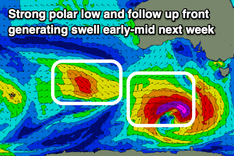 Swell wise, the SW groundswell should arrive through Monday afternoon, building to 3ft+ by dark on the Surf Coast and 4-5ft+ to the east, peaking Tuesday in the 4ft and 6ft+ range respectively.
The only issue are the local winds with a fresh S/SW breeze due to persist on Tuesday, swinging SE on Wednesday morning and only being moderate in strength but with easing size. The secondary front pushing up on the tail of the low will generate some reinforcing SW swell likely maintaining 3ft+ sets on the Surf Coast and 5ft surf to the east in the morning, easing thereafter.
Following the polar low and front, we'll see a healthy frontal progression pushing in under the country through Tuesday to Friday, bringing strengthening SW winds on Thursday and Friday as it clips us late week.
Moderate + levels of mid-period SW swell are due from this progression, building through Friday and holding Saturday to the 4ft+ range on the Surf Coast and 6ft+ to the east. Winds look a touch better with these swells with more variable breezes due Saturday morning, W/NW on Sunday but we'll have a closer look at this Monday. Have a great weekend!
Comments
Thanks for fixing the Southern Ocean wave machine Crangle. Better times ahead!
Hopefully kicking back into gear.
At least we know it can only get better. And she's well-rested.
Once the atmospheric pendulum swings, it'll be East Coast surfers cursing the Tasman Sea and contemplating a relocation to the southern states.
Should go and surf cold water Bells - said no East Coaster ever*
*maybe like 3 tops..
MP, Cheyne, and MF
Crangle ey.
Ha, yeah comes from the local grommies, and my unique angle I take of some of the local reefs. Craig angle = Crangle.
Is the Crangle like a fade? Is it something that can be taught?
There is a god !!!!!!!
Some swell ..... at last !!
Dare I say it, might actually get a surf in.......finally.
It's not the angle of the dangle, it's all about the Crangle;)