Poor week, better weekend

Victorian Surf Forecast by Craig Brokensha (issued Monday February 7th)
Best Days: Saturday and Sunday mornings on the exposed beaches
Features of the Forecast (tl;dr)
- Fading SW and SE swells tomorrow with NE tending E/SE winds
- Tiny Wed with dawn, fresh N/NE winds, shifting W/NW then S/SW and strengthening into the PM
- Building W/SW swell and S/SW windswell Thu with mod W/SW tending fresh S/SW winds
- Easing W/SW-SW swell Fri with fresh S tending SE winds
- Easing SW swell Sat with NE tending SE winds
- Inconsistent SW groundswell Sun with NE tending SE winds
Recap
Average waves for the keen on the beaches Saturday morning with a small, lumpy mix of swells, cleaner and better yesterday with an inconsistent new SW swell and more favourable E/NE winds. The Surf Coast saw poor levels of SE windswell all weekend.
Today both the SW and SE swells have eased with clean conditions on the beaches, easing from 2ft on the Mornington Peninsula and 1-2ft on the Surf Coast.
This week and weekend (Feb 8 - 13)
Down, down, down.
That’s the trend over the coming days with the weekend’s small, inconsistent swell fading further tomorrow as the SE windswell also continues to ease due to the lack of swell generating SE winds through Bass Strait.
 Winds will shift NE into tomorrow morning as a weakening mid-latitude low pushes in from the west, following the strong high out to the east.
Size wise both coasts look to be 1-1.5ft max, with Wednesday becoming even smaller with fresh, dawn N/NE winds, shifting W/NW mid-morning ahead of a strengthening S/SW change into the afternoon.
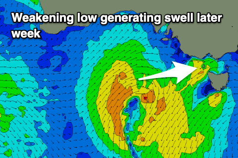
This change will be linked to the mid-latitude low pushing in from the west, while dipping south-east through our swell window.
Now, as touched on in Friday’s update the low will be strongest when north of our swell window, with a weaker fetch of strong W/SW winds being generated through our western and south-western swell windows as it dips south-east.
This will generate a small, mid-period W/SW tending SW swell that will build Thursday and likely peak Friday morning though winds will be W/SW tending fresh S/SW on Thursday and fresh S’ly tending S/SE on Friday. There’s a chance for a dawn W’ly on the Surf Coast Thursday morning but there’ll be no size, with the swell peaking later in the day and early Friday morning to 2ft to occasionally 3ft on the Surf Coast and 3-4ft+ to the east.
Winds are expected to swing offshore into Saturday morning from the E/NE-NE but the swell will be easing from 2ft on the Surf Coast and 3ft to occasionally 4ft on the Mornington Peninsula.
Sunday will be clean on the beaches again along with an inconsistent, long-range W/SW groundswell from the southern Indian Ocean. It’ll be very infrequent but sets to 2ft on the Surf Coast and 3-4ft+ to the east.
Longer term the increase in Southern Ocean activity hinted at by both global forecasting models late last week now looks to be unfortunately much weaker. Keep an eye on the coming updates.
Comments
Another write-off for Vic, when will this end :(
This is a dystopian nightmare.
Indeed it is. Even the wave pools are getting busy.
Busier than a certain inauguration?
I think I preferred it when Melbourne was in lockdown at least then we could watch / hear when crew living on the coast were scoring. Nobody is winning this summer.
Another fun head high surf today, best summer yet
You must vertically challenged FTT, it was tiny today
or a booger
or a stoner
Honestly, this is grim. I might need to take up golf
Do it! It's great fun!
You get to walk around for 4 hours yelling "fuck".
Hahaha very good. Fuck golf bores the shit out of me
Can anyone recall a summer this bad???
No.
Gday Ben. So on Sunday we got a nice yellow belly sea snake make land up at Torquay. Seemed to enjoy the beach , freaked out a few locals. Was a little far from home . I wondered on your thoughts with all the easterlies and the east coast current pushing down . I also noticed a nice purple heat map just off the coast of nsW and wondered if the little fella came down in that . How different or normal are the sea temps and currents at the moment down these ways .