Improving conditions to end the week but with average swells

Victorian Surf Forecast by Craig Brokensha (issued Wednesday 12th January)
Best Days: Friday afternoon exposed beaches
Features of the Forecast (tl;dr)
- Moderate sized SE windswell tomorrow on the Surf Coast with fresh E tending strong E/SE-SE winds
- Small, fading SE windswell Fri with E/NE-NE winds
- Small, weak, mid-period SW swell building Fri PM, fading Sat
- W tending fresh SW winds Sat, W/NW tending S/SE Sun
- Moderate sized + W/SW groundswell for Tue with fresh S winds, easing Wed with gusty SE winds
Recap
An average start to the day across all locations yesterday with a moderate to fresh S/SE breeze, but winds played out as forecast, easing and tending lighter E/NE for a period through the morning, cleaning up the beaches to the east. There was a mix of swells breaking, though down on Monday's size.
Today we've got cross-shore winds and bumpy, small surf to the east, while on the Surf Coast a new south-east windswell is on the build.
This week and next (Jan 13 - 21)
On Monday I mentioned the disagreement in the positioning of a surface trough/low moving in from South Australia and for a change GFS has won the battle over EC. The low will stay further south, squeezing a high to our south, bringing winds from the north-eastern quadrant.
We'll see winds become more favourable for the beaches from tomorrow, but the only issue is the lack of any swell from the south-west, with the energy mostly coming from the south-east.
A fresh E-E/NE breeze is due across the Mornington Peninsula, E'ly across the Surf Coast with easing levels of SE windswell from 3ft+. It's a tricky one with bumpy conditions due on the Surf Coast though workable across some beaches, while the Mornington Peninsula and Phillip Island will be cleaner but only 1-2ft.
Friday will be great condition wise with a moderate E/NE-NE breeze though swell wise it'll be small to tiny on the Mornington Peninsula (in the morning) and likely fading from 1-2ft on the Surf Coast.
Our small, weak, mid-period SW swell for Friday afternoon and Saturday morning is still looking suspect, with the swell generating fetch being NW and aimed mostly towards the pole.
 This isn't expected to top 1-2ft on the Surf Coast Friday afternoon, easing from 1-1.5ft on Saturday with 2ft to possibly 3ft sets on the Mornington Peninsula Friday afternoon as winds hold from the NE. With this in mind the afternoon and evening session is probably worth a shout on Friday.
Into the weekend the surf will be tiny and conditions favourable for the Surf Coast Saturday with a W'ly offshore giving into a SW change through the day, then back to the W/NW on Sunday morning ahead of sea breezes. There'll be no swell to surf though.
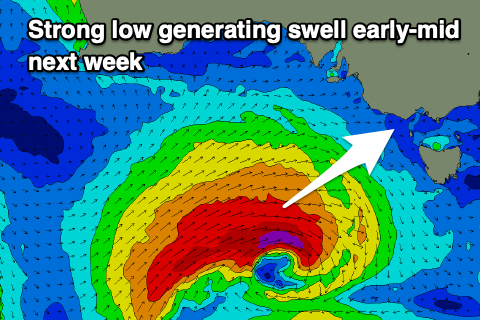
Moving into next week both models now have a mid-latitude low deepening under Western Australia this weekend, generating a tight fetch of gale to severe-gale W/SW winds. The slow moving nature of the low should help generate a moderate sized + W/SW groundswell for Tuesday, but with fresh S'ly winds as the remnants of the low moves through Monday afternoon, followed by a building ridge of high pressure. Winds will shift SE on Wednesday as the swell fades but options will be severely limited. More on this in Friday's update.
Comments
Huey are you there?
Winds are at least looking better than they were on the models last week.
Huey is clarly on vacation somewhere on the east coast! Can't blame really.
Any word on when the Lorne cam comes back on , asking for a friend …
Waiting for a replacement part to be sent down (country areas are much slower unfortunately).
Also the 13th cam? That other site has theirs back up at the same SC.
The other cam isn't on the surf club building, it's on the surf club tower across the road (so, not under construction).
On the topic of cams, is there a reason certain places have ability to replay where and Victoria's don't have? Thanks!