Average week of surf until late

Victorian Surf Forecast by Craig Brokensha (issued Monday 13th December)
Best Days: Friday morning until sea breezes hit, early Saturday exposed breaks for the keen, possibly early Sunday Surf Coast
Features of the Forecast (tl;dr)
- Small, weak W/SW swell building later tomorrow, peaking early Wed. Moderate S/SW winds tomorrow, light-mod S/SE tending strengthening S/SW winds Wed
- Light-mod S/SW winds Thu with an inconsistent W/SW groundswel building later, peaking Fri AM with light E/NE-NE tending SE winds
- Fading surf Sat with strengthening N/NE winds ahead of a mid-afternoon SW change
- Moderate sized, inconsistent W/SW groundswell Sun with SW tending S/SE winds, easing Mon
Recap
Our moderate sized S/SW groundswell provided plenty of size into Saturday morning with 3-4ft sets on the Surf Coast and 4-5ft+ waves to the east with workable, onshore winds. It wasn't great but there were waves for the keen.
Winds swung more offshore for the beaches yesterday morning but early was still mixed and raw with improving conditions mid-late morning with smaller levels of peaky swell.
Today the surf is all but gone with clean conditions on the beaches and leftover 2ft+ sets across the Mornington Peninsula, 1-2ft on the Surf Coast.

Fun leftovers today
This week and weekend (Dec 14 - 19)
The swell is reaching a low point and for the coming few days there'll be nowhere to recommend for a surf with incoming troughs due to bring onshore winds along with weak levels of swell.
The end of the week looks much better for surf though but read on for more details.
The first in a series of troughs will move through this evening, bringing strong SW winds which will abate into tomorrow morning but persist from the S/SW along with no new swell.
Into the afternoon a weak, new mid-period W/SW swell is due, generated by weak low that's currently south of the Bight. A fetch of strong W/SW winds will be generated in our western swell window with the swell kicking late tomorrow to 2ft on the Surf Coast and 3-4ft to the east, peaking Wednesday morning to 2ft+ and 4ft respectively before easing during the day.
Winds unfortunately now look to linger from the S/SE into Wednesday morning, swinging S/SW during the day and strengthening as another weak trough pushes in from the west.
Winds will linger out of the S-S/SW into Thursday with a fresh low point in swell but we'll see a new, inconsistent W/SW groundswell building through the day, peaking Friday morning across the state. This will be when winds finally swing back to the E/NE-NE creating fun options on the beaches.
The source of this long-range groundswell was a strong low forming in our far, far swell window, south-east of South Africa, generating a fetch of gale to severe-gale W'ly winds on the weekend. The low has since broken down south-west of Western Australia with the groundswell now heading towards us.
It'll be inconsistent and on the small side but the Surf Coast should reach 2ft on the Surf Coast with the possibility of the rare bigger one on the magnets and 3-4ft to the east with the possibility for the rare bigger one.
Afternoon sea breezes will develop Friday so try and surf through the morning for the best waves.
Come Saturday a strengthen N/NE wind is due ahead of a cold front and strong, afternoon SW change but the swell will be weak and fading from 1-2ft max on the Surf Coast and 2-3ft to the east.
 This change will mostly spoil a better, inconsistent W/SW groundswell for Sunday, with lingering SW tending S/SW winds due into the second half of the weekend.
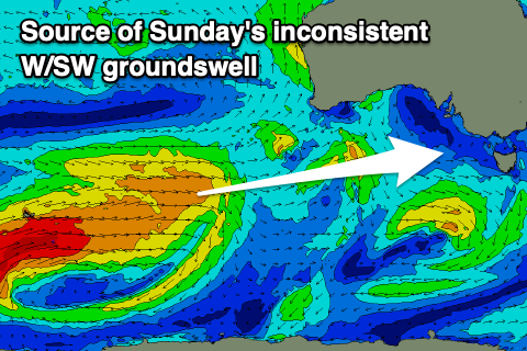
The source of this swell is a secondary strong frontal progression and polar low firing up on the tail of the weakening low linked to Friday's swell.
A great fetch of initially gale to severe-gale W/SW winds will be generated around the Heard Island region, weakening a touch while moving further east towards us. This should produce a more consistent, moderate sized W/SW groundswell for Sunday that looks to offer surf in the inconsistent 3ft range on the Surf Coast and 4-5ft+ to the east.
There might be a window of early W'ly winds on the Surf Coast but generally it'll be bumpy and average.
Into early next week the outlook is divergent regarding a strong mid-latitude low forming in the Bight so we'll have to have a closer at this on Wednesday.