Good couple of days, poor thereafter

Victorian Surf Forecast by Craig Brokensha (issued Monday 22nd November)
Best Days: Tomorrow, Wednesday
Features of the Forecast (tl;dr)
- Building SW groundswell tomorrow PM with fresh N/NE winds
- Easing SW groundswell Wed with light E/NE tending SE then S/SE winds
- Mix of swells Thu with moderate S/SW winds, strengthening from the S'th through the day
- Mix of inconsistent W/SW groundswell and SE windswell Fri with strong SE winds
- Easing mix of swells with moderate SE winds
- Small leftovers with light S'ly tending S/SE winds
Recap
Bumpy though workable conditions on Saturday with waves to 2ft to occasionally 3ft on the Surf Coast and 3-4ft waves to the east, building further into the afternoon with a new mid-period S/SW swell but with freshening winds.
Yesterday was average with fresh S'ly winds, while today is similar with a bit less size and waves for the desperate.
This week and weekend (Nov 23 - 28)
After the last two days of onshore winds, tomorrow is looking much better and the pick of the forecast period as a weakening low moving in slowly from the Bight shifts winds to the N/NE, holding all day and fresh in nature.
The day will start on the small side of the coin, with a new SW groundswell due to arrive around midday and build through the afternoon ahead of a peak later. The source of this swell was a strengthening polar low under the country yesterday, with a great fetch of W-W/NW gales tracking east-southeast through our swell window.
 It strengthened a touch later than forecast on Friday but we should see the Surf Coast building from the 2ft+ range tomorrow morning to a more solid 3ft into the afternoon (possibly rare bigger one) with 3-4ft sets on the Mornington Peninsula building to 4-5ft into the afternoon (also possibly odd bigger one).
Wednesday morning should see similar sized sets, easing through the day with a light E/NE offshore ahead of weak SE tending S/SE sea breezes.
Thursday morning is looking a touch smaller again with background energy from weak trailing frontal systems due to maintain 2ft to occasionally 3ft sets on the Surf Coast magnets, 3-4ft+ to the east. Winds will start to deteriorate though as a trough then high move in from the west, bringing moderate S/SW winds that will strengthen from the S'th as the trough deepens and the high continues to strengthen from the west.
The trough is forecast to form into a low off the far southern NSW coast Friday and then slowly move south-east towards New Zealand through the weekend.
This will see winds swing SE on Friday and become strong, kicking up a moderate sized SE windswell, with winds relaxing from the SE on Saturday as the low slowly drifts away, possibly more variable Sunday morning.
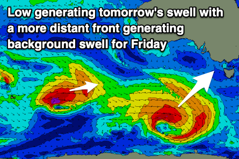
Unfortunately the high and low combo will block our main swell windows with a mix of background W/SW groundswell (the source os shown in the image above) and SE windswell Friday to a junky 3ft, 4ft+ to the east. These swells will fade Saturday and Sunday as those winds relax.
Into next week we'll see some stronger frontal activity generating some new groundswell energy early-mid week with more favourable winds. More on this in the coming updates and in the meantime make the most of the coming days!
Comments
Is this normal ? seems like a lot more Easterly components pestering the charts compared to what would be expected looking at last 5 years averages charts ?
Yeah all due to the negative IOD and La Niña, more easterly winds and less swell.
Good size this afternoon..
Craigos are we still looking good for offshore winds tomorrow morning?
The models are forecasting a bit of nw?
NW is offshore ;)
One mans pleasure another mans pain vj
Bonus uncrowded good quality waves on the S.C late today.
Had 2 good surfs today so won't be that fussed when the hoards arrive tomorrow on a forecast promise.
Wasn’t today forecasted to be the pick of the bunch?
From Craigos himself on Monday “ tomorrow is looking much better and the pick of the forecast period “
Well if it was it was probably referring to the MP or PI with the forecast NE wind direction.
Ha, yeah. Looks nice and glassy early this AM. But yesty was the day.