Make the most of today and the end of the week

Victorian Surf Forecast by Craig Brokensha (issued Wednesday 6th October)
Best Days: Today, Friday, Saturday morning, Tuesday on the beaches
Features of the Forecast (tl;dr)
- Building W/SW windswell tomorrow with strong W/SW tending SW winds (W/NW early west of Melbourne)
- Fun, mid-period W/SW swell Fri, easing through the day with mod-fresh N/NW winds, easing later (tending N/NE into the afternoon east of Melbourne)
- Easing swell Sat with mod N/NW tending S/SW winds
- Building mix of inconsistent W/SW groundswell Sun with strengthening SW tending S/SW winds, easing Mon with strong S/SW winds
- Easing swell Tue with N/NE tending SE winds
Recap
A very slow start to yesterday with strong winds out of the west but just a tiny westerly windswell. Our new mid-period but tricky W'ly swell filled in through the day, with the afternoon offering the most size to the 3ft+ range on the Surf Coast and 5-6ft to the east. Conditions were OK in protected spots on the Surf Coast for the desperate but today is providing plenty more options.
The mid-period W/SW swell is easing and we've got much better winds for the Surf Coast, improving to the east with easing 2-3ft and 4ft surf respectively.
Winds will swing more N/NE-NE while easing on the Mornington Peninsula and Phillip Island this afternoon, variable N/NW on the Surf Coast. This should provide plenty of options for the afternoon and evening session.

Improving options on the beaches
This week and weekend (Oct 7 - 10)
Tomorrow will be a lay day, with the swell coming in small and weak ahead of a building windswell through the day as a cold front pushes through. Strong W/SW tending SW winds are due, with the Surf Coast likely to see early W/NW winds but no real size or quality. It'll be best for beginners.
This front only looks to kick up 2ft or so of weak swell for the Surf Coast through the day, choppy and to 4ft to the east.
Our slightly better mid-period W/SW swell for Friday is on track, as are the improvement in winds and conditions. This swell has been generated by a tight, relatively weak, slow moving low that formed south of Western Australia Monday evening and yesterday.
Swell wise it looks to be a little smaller than forecast on Monday, coming in at 3ft on the sets across the Surf Coast magnets, with 4-5ft waves to the east.
 Conditions will be best on the Surf Coast in the morning with a moderate to fresh N/NW offshore, but we should see winds tending N/NE into the afternoon east of Melbourne, creating improving conditions as the swell starts to ease.
Saturday will be smaller but best on the Surf Coast with easing 2ft+ sets and a moderate N/NW tending S/SW through the afternoon with a weak front.
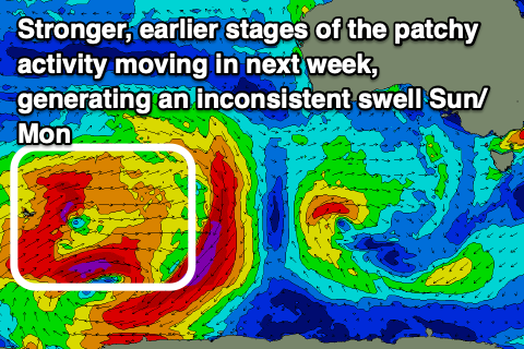
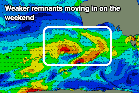
This initial weak front will be at the head of a flurry of broader activity moving in from the west late week and into the weekend, but it'll be mostly unconsolidated and not the greatest swell producer. The initial stages of this activity, stronger and broader fetches of W/SW gales east of Heard Island will add an inconsistent groundswell to the mix.
 Coming back to the activity moving in from Sunday, and it'll bring poor winds, strengthening SW tending S/SW on Sunday, persisting from the S/SW into Monday. Swell wise, we should see a building mix of mid-period W/SW swell and W/SW groundswell Sunday, holding Monday morning to 3ft+ on the Surf Coast and 4-5ft+ to the east.
Tuesday looks the pick with easing surf from 2ft+ and 4ft respectively as winds swing back around to the NE, tiny Wednesday but clean for the beaches again.
Longer term the outlook is still fairly hit and miss as mid-latitude lows and fronts push in from the west bringing variable winds and funky swells. More on this Friday and make the most of today.
Comments
Model forecast for tomorrow just dropped from 5-6ft to 2ft
Hope Craig's right
We lost a day of data on Tuesday when the model went down. So that swell isn't showing on the charts.
Ok thanks Craig :)
So does that now mean swells not coming?
No not at all. Just generated during the down time mostly.
Thanks mate.. 1ft slop on the reefs right now..
It's a weak swell I'd keep your expectations low.