Large, raw swell easing tomorrow, improving from Wednesday but smaller

Victorian Surf Forecast by Craig Brokensha (issued Monday 16th August)
Best Days: Protected spots tomorrow morning, Wednesday Surf Coast, Thursday, Friday morning for the keen on the beaches, Sunday on the beaches
Features of the Forecast (tl;dr)
- Large, easing S/SW groundswell tomorrow, easing further Wednesday while becoming mid-period
- Fresh SW winds tomorrow (period of early W'ly winds around Torquay), better Wed with NW winds
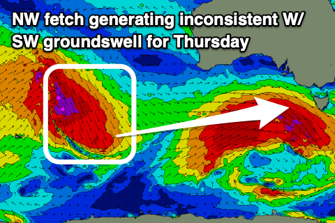
- Inconsistent W/SW groundswell for Thu, likely peaking into the PM with N/NW tending N/NE winds
- Easing W/SW groundswell Fri with strong N/NE winds
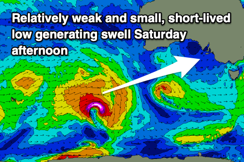
- Inconsistent W/SW swell building later Sat, peaking Sun with a mid-period W/SW swell in the mix
- Strong N/NW tending W/NW winds Sat, strong N Sun
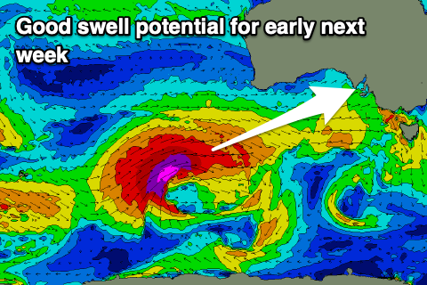
- Large W/SW groundswell likely early next week
Recap
Pumping surf on Saturday with a strong, new W/SW groundswell and clean conditions all day on the Surf Coast, best in protected spots to the east. The swell eased later in the day and then back from 3ft on Sunday across the Surf Coast with similar, though slightly stronger offshore winds.
Today we've got a mix of new mid-period SW swell ahead of a larger groundswell due this afternoon generated by a strong polar low firing up in our swell window over the weekend.
Windy, 4-5ft waves were seen across the Surf Coast early, now pushing 6t+ as winds create, bumpy raw conditions. We should the swell reaching 6-8ft but as winds shift strong SW.
This week and weekend (Aug 17 - 22)
With the large, long-period SW groundswell currently filling in across the state, the low linked to the swell is still generating S/SW gales through our southern swell window, south-southwest of Tasmania this morning.
This should slow the easing trend of the swell into tomorrow as the direction swings S/SW. The Surf Coast should still offer 6ft sets on the swell magnets early, with 6-8ft surf to the east, dropping through the day and then down from a much smaller 3ft and 4ft+ respectively on Wednesday.
 The easing trend will be quite steady so if looking for size hit it this afternoon or early tomorrow.
Winds tomorrow are still due to be average with fresh SW'ly breezes across most locations apart from a short-lived window of W'ly winds around Torquay early. In any case the surf will still be lumpy/bumpy and raw after this afternoon's SW change and with SW winds through Bass Strait.
Wednesday looks much cleaner with a NW breeze holding all day along with that easing swell in both size and energy.
Come Thursday winds will improve for the beaches with a N/NW tending N/NE breeze along with a new, infrequent W/SW groundswell. The source of this swell was a fetch of gale to severe-gale NW winds ahead of a strong mid-latitude low, drifting south-east through the southern Indian Ocean.
 This system is now breaking down on the polar shelf, south-southwest of Western Australia, with an inconsistent, tricky swell due to fill in Thursday and likely peaking through the afternoon.
The models are incorrectly combining swells and over-forecasting the size a touch, but radial spread off the fetch should still help see the Surf Coast offer 2-3ft sets (more so 3ft on the swell magnets), with 4-5ft+ sets to the east.
The swell is then due to ease Friday with stronger N/NE winds as a mid-latitude frontal system approaches from the west.
This system and a more distant, stronger low firing up north-east of Heard Island look to generate some new, inconsistent mid-period W/SW swell for Saturday afternoon but more so Sunday.
 No major size is expected with 2ft to maybe 3ft sets developing on the Surf Coast Saturday afternoon, but more so Sunday to 2-3ft, with sets to 4-5ft due on the Mornington Peninsula.
Winds will become less favourable for the beaches with strong N/NW tending W/NW breezes Saturday as the mid-latitude front pushes in, back to the N'th on Sunday, opening up more options.
Of greater importance is a stronger low that's due to fire up behind these weaker initial systems, generating a large W/SW groundswell for early next week. We'll look at this system closer over the coming updates but we're likely to see winds out of the west during the peak of energy. More on this Wednesday.
Comments
Skate parks in Melbourne closed - not sure if looking at the surf cams help or hinder my mental health.
the skate parks been a real refuge/ a saviour.. ahh well, back to street skating.
Some footage of Bells and Winki today
A bunch of crew having a ball in big wild surf. A great way to remember a legend in Shaun Brooks. Hats off to all involved. Great footage.
That first wave was sick....how the fuck did he make that section thought he was gone after the takeoff
* next section
Yeah sick first wave and what a make as you said MDM
Was fluro yellow board Adam Robbo?
Ripping
Yeah smooth as silk isn’t he
Just showed the wife a couple of my waves in the vid and she said "the only footage I like to watch is Medina".
Absolutely devastated.
Looking at the wams the fetch producing the swell for Thursday you'd think would be hitting the surf coast from quite a west direction but the models are saying its quite south. Is this to do with a great circle path or what
The model guidance I'm seeing has the angle at 237deg, so fairly west. Not sure where the south is coming from?
for this coast that’s considered fairly south for the waves, anything more than 245 degrees is considered more west. 5-10 degrees Makes a huge difference around here
Regardless the swell will be coming in with more of west bias than south.