Tricky west swells, below model forecasts

Victorian Surf Forecast by Craig Brokensha (issued Friday 23rd July)
Best Days: Surf Coast Saturday, protected spots Sunday, Surf Coast Monday, Tuesday, Wednesday onwards protected spots
Features of the Forecast (tl;dr)
- Fun, mid-period SW swell tomorrow with strengthening N/NW tending NW winds
- Mix of moderate to large W/SW swells Sun with strong W/NW winds
- Better though inconsistent W/SW groundswell Mon, easing during the day with strong NW winds
- Smaller surf Tue with strong N winds (N/NW Surf Coast)
Recap
Lots of options for a fun wave across all regions yesterday with surf mostly to 3ft on the Surf Coast, 4-5ft to the east and with strengthening N'ly winds into the afternoon.
This morning the swell was similar though a little slow at dawn, but we've got a bit more energy in the water now with favourable conditions across most regions again.
This weekend and next week (Jul 24 - 30)
The steady run of moderate sized swell seen from yesterday through today, will hold into tomorrow with the Surf Coast due to continue to see 3ft sets on the swell magnets, 4-5ft to the east. Again there might be the rare bigger one at times, with the size due to ease later in the day.
Winds will become less favourable for the Mornington Peninsula beaches as a vigorous mid-latitude front moves in from the west, bringing strengthen N/NW tending NW winds.
We then look at the tricky and very west swell due into Sunday and Monday across the region.
 First up, expectation wise, keep them lowered as it looks like the bulk of the swell generating fetch will be blocked by Cape Otway.
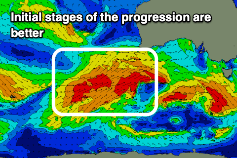
The mid-latitude frontal progression linked to the swell is currently projecting up and under Western Australia with a broad fetch of W/SW gales just within our medium-range western swell window.
We'll see the strongest front push up and on top of this active sea state towards the Bight this evening, but it will be mostly too far north of our swell window. This front will generate large, stormy surf for South Australia, but for us, we're instead going to see weaker, patchy fetches of strong to gale-force W/SW winds in our western swell window.
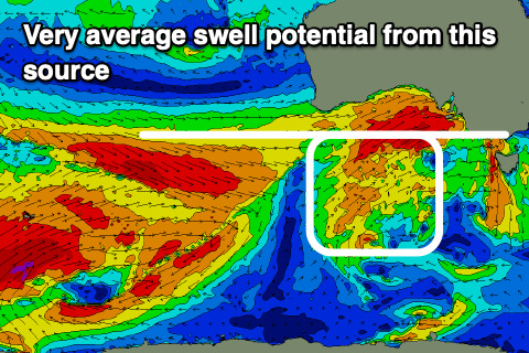 What will help produce some additional size Sunday will be an intensification of the frontal system as it enters Bass Strait on Saturday evening and early Sunday, but we'll be seeing mostly mid-period W/SW swell energy across the state.
Size wise, expect a wide range of sizes mostly to 3-4ft on the Surf Coast with the odd 5ft'er on the swell magnets through the day, 6ft to occasionally 8ft to the east. Strong W/NW winds will favour protected spots all day, though these will be smallest.
This is under the model forecasts so don't expect 6ft surf Sunday morning on the Surf Coast.
On Monday there should be a bit more period to the swell, generated by the initial stages of the frontal progression but it'll be inconsistent. Sets to 3-4ft are due on the Surf Coast magnets, easing through the day and 5-6ft+ to the east. Winds will be better on Monday and strong from the NW all day.
Tuesday will be smaller again and likely to 2-3ft on the Surf Coast, 4-5ft to the east as winds shift stronger N'ly ahead of the next frontal system.
Some reinforcing, inconsistent W/SW groundswell is due into the afternoon, generated by a pre-frontal fetch firing up, south-west of Western Australia, though size wise it looks to just steady wave heights on the Surf Coast to 3ft, possibly providing the odd 6ft'er on the Mornington Peninsula.
Into Wednesday well see another strong mid-latitude front push in, but again most of the activity looks to be too far north of our swell window, limiting the size across the Surf Coast. It could be a touch better than the weekend's swell but we'll review this Monday. Have a great weekend!
Comments
Help a locked down brother out, Craig. What do you make of the bay winds on Sunday morning? I see you've got strong W/NW forecast for Surf Coast.
SW would be handy for town if you can arrange that.
Yeah, gonna be W/NW through the bay as well unfortunately.
Bummer. Thanks anyway.
Just Cruze down the surfcoast for a quick splash mate. Apparently no one has payed a DHHS fine for covid breach anyway. And the police in gtown are too busy chasing leads from "ringlicker" Dobbin in all his mates for walking 5.1k. too far from home.
#justsaying
#ringlicker
I think the army will be doing the police work this time next week when the whole nation goes full lockdown
Get stuffed removalists.... get stuffed Gladys.
If I was a Victorian (I kind of am/was) I'd be angry in this direction as well. In particular given past PM / premier patronising tendencies.
Im pretty sure though the Delta wave started with a pilot meets a limo driver story, so I'm sparing a thought for the removalists incurring everyone's wrath.
I also remember watching a 4corners a few months back and a medical type warning it will come again.
When you look at UK vaccination rates I know where my frustration is directed, the top.
Stoked with how today has planned out, tricky forecast and hard to sometimes go under what all the buoys and models are showing.
16 day forecast winds don’t go below 20knots. What sustains such a windy period? Not like a system come system go, just consistent wind
Hey Bonner in my personal opinion the bom and other weather forecast sites are not good at prediction W wind and strength of it. Check all area port Phillip bay/animated marine/met eye. All called 30knts for today. Now look at Airely inlet data for today it bombed out below 10knts after noon today. This happens 9/10 times with W wind. And also it held nw Not the predicted W (CB had his finger on the pulse there).
W wind is comming off land so it's dirty and inconsistent but bom doesn't take that into account I personally think. And always write a weather forecast to make sure know one goes boating and does not reflect what its actually going to do from 7am-5:30pm. For the record that's my personal opinion.
#justsaying
#ringlicker
Blowing it’s tits off all day on the MP, consistent high 20s/low 30s all day. Any ideas Craig? Otways filtering it a bit but the bay ramping it up again?
Persistent, drawn out, zonal node of the LWT across the country. It's just bringing front after front after front.
Yep .the Juiliets are happy..