Lots of wind and moderate sized swells

Victorian Surf Forecast by Craig Brokensha (issued Monday 19th July)
Best Days: Surf Coast tomorrow morning, Thursday (beaches into the afternoon), Friday on the beaches, Saturday Surf Coast, protected spots Monday
Features of the Forecast (tl;dr)
- Mix of new SW swells tomorrow with strong NW tending stronger S/SW winds around midday
- Building mid-period S/SW swell later tomorrow, easing Wed with fresh to strong S/SW-SW winds, easing later
- Mix of similar sized mid-period swells Thu-Sat AM with fresh N/NW winds Thu (tending N east of Melbourne into the PM), fresh to strong N/NE winds Fri, strengthening N/NW Sat
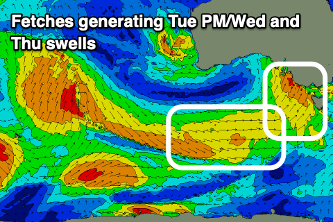
- Building W'ly groundswell later Sun, peaking Mon
Recap
A tiny start to the weekend but some new W/SW swell started to build through the afternoon, clean in protected spots ahead of a mid-afternoon W/SW change. Yesterday was better though slightly lumpy with 3ft+ waves on the Surf Coast and generally favourable conditions all day in protected spots.
Today the swell is less consistent but a similar size to yesterday afternoon owing to a longer-range SW groundswell. Conditions are great on the Surf Coast and winds will hold from the NW all day.
This week and weekend (Jul 20 - 25)
Looking at the week ahead and we've got a windy one with a mix of swells on the cards but options across all locations for the period.
 Firstly a mix of new SW swells are due tomorrow, generated by pre-frontal W/NW winds moving in from the south-east Indian Ocean, swinging to the W/SW as the front formed into a polar low south of Western Australia.
Sets to 3-4ft are due across the Surf Coast swell magnets with 5-6ft+ sets to the east, but winds will be strong and out of the NW, giving into an even stronger S/SW change around midday. So while the Surf Coast will be clean, it'll be tricky with the strong, morning offshore.
This change will kick up a sizey increase in mid-period swell for the afternoon and Wednesday morning to 3-5ft on the Surf Coast and 6ft+ to the east. Winds will unfortunately remain onshore and fresh to strong from the S/SW-SW on Wednesday with the chance of a dawn W'ly unlikely. Thursday will become cleaner ahead of a mid-latitude low moving in from the west, swinging winds around to the N/NW, likely even tending N'ly east of Melbourne into the afternoon.
 Swell wise, there'll be mid-period energy leftover from Wednesday, mixed in with a new pulse for the late afternoon, generated by broad and elongated, pre-frontal W/NW winds swinging in under the country tomorrow and Wednesday.
The Surf Coast looks to hold around the 3ft range, 4-5ft+ to the east, similar Friday under fresh to strong N/NE winds, easing later in the day. Background energy looks to maintain similar sized surf Saturday morning with a shift in winds to the N/NW, strengthening through the day.
As we move into Sunday and Monday, a very strong mid-latitude frontal progression will push in from the west, with multiple embedded troughs and even a possible low pressure centre forming right on us.
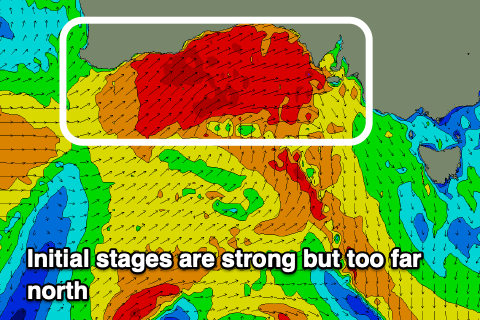
 As has been the trend most of the winter, the activity will track fairly far north and less than ideally through our swell window, with fetches of gale to severe-gales projected mostly through the Bight and into South Australia.
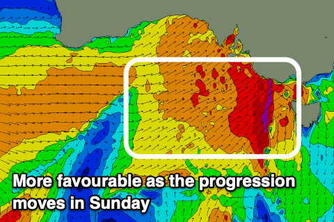
As the progression nears closer we'll likely see severe-gales generated just within our western swell window, but we'll have to continue to monitor it through the week. At this stage it looks like a similar though stronger setup to what we saw on the weekend, with the Surf Coast due to build Sunday afternoon but peak Monday to 3-5ft on the Surf Coast and 6-8ft to the east. Winds look strong but from the W/NW, though we'll confirm this Wednesday and Friday.
Comments
Been some fun ones the last few days. It's a lot more normal than the flat spell we had previously.
Yeah, it's looked really fun!
Change is imminent across the greater Surf Coast.
Also, winds are now looking better for the region tomorrow morning, with a moderate W/NW breeze likely to hold most of the day, though the surf will be lower quality and lumpy.
Yes, proper winter conditions, cold, strong offshores, rain squalls and some decent swell most importantly.
and less people in the water!
Surfed some real good waves for 2.5 hours earlier today with a pretty small crew given the conditions. Raining just about the whole time and very dim & dark with a cold/icy wind.
A cracker of a day in Southern Victoria!
I got out of the water just after the change had really kicked in. It reminded me of the scene in Caddyshack where Carl the Greenskeeper and the Preacher were battling their way up the final fairway in hurricane force winds and driving rain. RAT FARTS.
How quiet is it around Torquay? The 5km limit must keep some spots nice and quiet.
Morning reports looked almost empty there and towards BH.
Quieter than normal but then it's an absolute c##t of a day unless you're a surfer. Plus wind has gone cronshore now so wave quality is gone.
Haha yep. I'm hoping that wind really gets feral and there's a tiny bay wave later today.
Wind change has moved through and it feels proper winter.
Bnkref it's been reasonably quiet on lesser reefs, lots of people doing a walk or promenade tho. 4-5 for where I've gone.
SA has just done a lockdown, 2.5km exercise radius. That one would ruffle lots of feathers down here lol
That's great numbers in the water. Enjoy the quiet surfs while you still can.
Yeah I saw that about SA. I'm from there originally. 2.5km is tight! My sister lives about 1km from Middleton though which is handy, so she's still good to get in the water.
2.5km.... what a funny little flex from SA Gov. Not unexpected though I guess, when pizza man threatened them last year nobody was even allowed outside to walk their dog for a few days. Bottleshops remained open of course though, always do.
This morning felt like first proper surf coast winter surf for me since the move. Loved it.
And the funny thing is, the BOM got the forecast slightly wrong. Heavy rain? check. 13 degrees going back to single digits after the change? check. 80 km/h gusts? check. but where was the forecasted hail??
I don't miss Indo at all.