Average outlook for the state

Victorian Surf Forecast by Craig Brokensha (issued Wednesday 26th May)
Best Days: Tomorrow morning Surf Coast, Sunday on the beaches, desperate surfers Surf Coast Monday morning
Features of the Forecast (tl;dr)
- Mid-period W/SW swell easing tomorrow, with a new mid-period SW swell for late in the day and Fri
- Gusty W/NW winds tomorrow, swinging strong W/SW-SW early-mid afternoon, strong but easing S/SW tending S Fri, moderate S/SE Sat
- Inconsistent W'ly groundswell building Sun PM with E/NE tending variable winds, easing Mon with NW tending S/SW winds
Recap
A small, slow start to yesterday morning but our inconsistent W/SW groundswell due to build through the day started to show after dawn with near flat conditions in between 3-5ft sets to the east, 1-2ft on the Surf Coast with 3ft sets. The swell really didn't push much higher through the day with with strong N'ly winds and developing rain the afternoon wasn't too flash.
Today we've got a mix of mid-period energy and easing groundswell with windy 3ft waves on the Surf Coast, 4-6ft to the east and only really for the keen.
This week and weekend (May 27 - Jun 4)
The dominant swell this afternoon and tomorrow morning will be mid-period W/SW energy, generated by the backside of a mid-latitude low pushing in and across us, bringing all this wind and weather.
The trailing fetch of W/SW-SW winds in our south-western swell window now look a bit weaker and the reinforcing, mid-period SW swell for tomorrow afternoon and Friday morning a touch weaker.
 Generally we should see surf to 3ft across the Surf Coast through tomorrow and Friday, 4-5ft to the east. Winds will only be favourable tomorrow morning though with a gusty W/NW breeze, shifting strong W/SW-SW early-mid afternoon.
Friday will unfortunately be a write-off with strong S/SW winds moving in in the wake of tomorrow's change as a broad Tasman Low develops in the Tasman Sea, directing strong S/SW winds up the Eastern Seaboard. Winds will abate a little and swing more S'th into the afternoon, with moderate S/SE winds persisting into Saturday as the size eases.
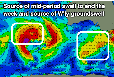
Sunday looks to offer a window for the beaches and a new, inconsistent W'ly groundswell is due to fill in through the afternoon, peaking into the evening.
The source of this swell will be a strong mid-latitude low moving through the Indian Ocean, but fairly north in latitude, just within our western swell window.
A persistent fetch of W'ly gales will be produced, with the low breaking down, south-west of Western Australia on Friday morning.
The swell should push east and arrive late morning Sunday, building into the afternoon, with the Mornington Peninsula due to increase from an inconsistent 3ft in the morning, up to an inconsistent 4-5ft on the sets late afternoon. Winds should be out of the E/NE through the morning, possibly variable into the afternoon. The Surf Coast isn't expected to see much size at all with stray 2ft sets max likely on the swell magnets.
Monday will become cleaner on the Surf Coast with a NW breeze ahead of a shallow S/SW change but only a small, fading 2ft wave.
For the rest of the week there's nothing too significant on the cards at all with mid-latitude systems and highs set to dominate our main swell windows.
We should see an increase in Southern Ocean activity from late in the week, bringing swell from next weekend, but more on this in the coming updates.
Comments
Here we go again crew, 5km limit is back. Lucky the forecast is looking pretty damn average
Yeah Groundhog Day.
Fantastic.
Vic regional housing market likely just given another little nudge upwards...
+ NSW / Qld housing markets haha
Spot on.
Also whilst those states haven't locked down, it's likely a few Vic residents who had booked or were planning winter holidays up north are now reconsidering. The tourism sector takes another hit.
Bummer, but yes the forecast is fairly forgettable.
Gee the headline for this forecast was spot on.
Handy for the lucky ones that live within 5km from the surf. That ain't me...
Eldest booked flight to Perth to go finish studies in H2 2021 on the Sunday night, cases begin to ramp on the Monday, flights getting cancelled now, WA border goes *Slam!* in onomatopoeic fury, d'oh.
And it was a really nice week last week, surfed every day apart from Thursday so I guess I made the most of it.
Yeah fuck driving to piss weak Torquay at this time of year anyway. Getting close to the flu season