Plenty of swell on the way, with pockets of good winds

Victorian Surf Forecast by Ben Matson (issued Wednesday 5th May)
Features of the Forecast (tl;dr)
- Strong swells persisting for the next few days
- Great conditions for East Coast Thurs, but poor on the Surf Coast
- Improving west of Melbourne on Friday with more groundswell and generally light winds
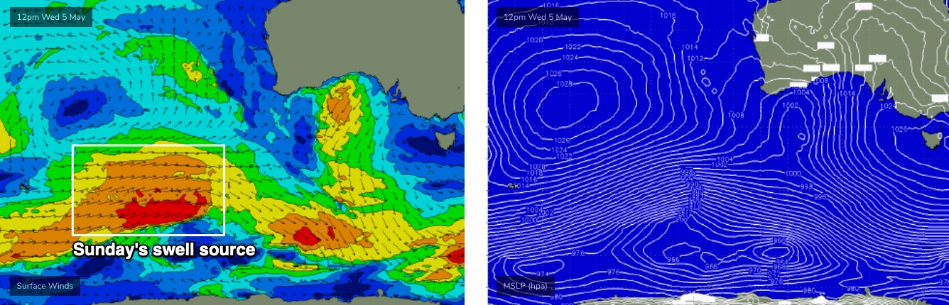
- Strong new groundswell on Sunday with light winds
- Plenty more surf into next week!
Recap
Strong onshore winds have limited surfing options throughout Victoria as a large swell pushed wave heights into the 5-6ft range west of Melbourne on Tuesday, and 6-8ft east of Melbourne. A gradual easing of surf size and wind strength into today hasn’t really benefited surfers at all.
This week (May 6 - 7)
*Today’s Forecaster Notes will be brief as Craig is away*
Easterly winds will develop overnight as a ridge of high pressure builds south of the state. This won’t do many favours for the Surf Coast thanks to a likely side-shore wobble up the face at most breaks (slow 3ft+ open beaches/reefs), but this breeze should clean up the open beaches east of Melbourne nicely.
However, surf size will remain at the upper end of a typical beach break threshold, with size between 4ft and occasionally 6ft thanks to trailing pulses of supplementary energy following Tuesday’s large event.
Late in the day, we’ll see an embedded pulse of stronger energy showing at the buoys with a more pronounced increase in peak swell periods (to 16-17 seconds), which should lift Friday morning’s surf size to 3-5ft in Torquay, and 6ft+ east of Melbourne. Expect very long breaks for the upper end of this size range, but there’ll be plenty of smaller mid-range waves filling in the gaps.
Even better, the ridge south of the state will move slowly east and this will allow winds to weaken as a trough of low pressure approaches from the west. This should create light N’ly winds across most coasts.
There’s a risk that the Surf Coast will retain some surface wobble from Thursday’s breeze but it should certainly improve through the day. Otherwise, expect clean conditions elsewhere.
This weekend (May 8 - 9)
The models have slightly pulled back core wind strengths within the fetch generating the new swell due on Sunday. However, the storm track still looks really good (see below) so we’re on target for another nice round of strong autumn surf.
Saturday will see temporarily easing wave heights (this trend may actually kick in on Friday afternoon), and a cold front is expected to clip the coast, freshening W/NW winds ahead of a swing to the W/SW around lunch.
The Surf Coast should manage 3ft sets on Saturday, perhaps becoming a little smaller through the day and certainly losing some consistency. East of Melbourne, winds won’t be favourable for most breaks and it’ll be too small for Western Port.
Sunday’s new swell should lift surf size to 3-4ft at most breaks, peaking at 4-6ft across the reliable swell magnets, and conditions should become nice and clean as a front rears up from the west, and swings the winds to a light to moderate N’ly. Set waves will be a little inconsistent but it shouldn't be detrimental to the surf opportunities.
East of Melbourne will be pretty big on Sunday, around 6-8ft at exposed spots so best suited to sheltered locations where we’ll see smaller though equally clean surf.
Well worth your time and attention!
Next week (May 10 onwards)
Sunday’s approaching front has a tricky swell source attached to it, which I’m not confident will produce waves. It’s a deepening cut-off low that will undergo cyclogensis south of WA, and eventually track northwards up into South Australia. This suggests the bulk of the swell will be pointed at coastlines well west of Victoria.
What this does to the surf forecast is remove the potential for both large surf AND windy conditions early next week. Instead, we’ve seen an abrupt about-face and it’s now looking to be clean with light winds and small to moderate swells for a few days (ballpark 2-3ft Surf Coast).
Of course, a slight change in the position of the cut-off low could swing the pendulum back the other way. So right now, confidence is low on next week’s outlook - don’t go planning anything (surf, or non-surf).
Regardless, the Southern Ocean is very active at the moment, and so even if we do experience a slump in energy early next week, chances are very high than the second half of next week and the weekend will see an immediate return to strong autumn/winter synoptics.
More on this in Friday’s update.
Comments
I like this forecast :-).
Right on Mr T
bit of a sleep in yesterday benny?
Eh?
Tough crowd down here! Good looking forey to me.
Forey was worth the wait... a man deserves a sleep in every now and then
Sleep in?
Normally around 11 am ish .
The deciples hang on your every word..
That's Craig's schedule... unfortunately I've got a different routine when I'm filling in. But I'll try to get it out ASAP today.
New swell is running a little late and is undersized at the moment, but there's still some nice waves at Torquay this morning.
