Plenty of strong surf, though average conditions for a few days

Victorian Surf Forecast by Ben Matson (issued Monday 3rd May)
Features of the Forecast (tl;dr)
- Plenty of solid groundswell all week, plus some SE windswell (Surf Coast) on Friday
- Poor winds for the Surf Coast for the next few days, Friday the pick of the working week
- Great surf east of Melbourne from later Wednesday and (more likely) Thursday under an E'ly flow
- Good weekend of waves with a solid groundswell peaking Sunday
- Strong surf next week though more likely to become wind affected
Recap
The open beaches east of Melbourne offered small clean waves over the weekend, with slow sets either side of 2ft and offshore winds. There wasn’t much surf west of Melbourne. Today has seen an initially small, slow building trend, with early NW winds swinging SW through the day. Certainly nothing to get excited about. Larger waves are due late today but conditions are continuing to deteriorate as the onshore breeze strengthens.
This week (May 4 - 7)
*Today’s Forecaster Notes will be brief as Craig is away*
Recapping Craig’s expectations for the new swell due later today, and the Cape Sorell buoy has recorded a jump in swell periods and wave heights since about late morning. However, as per the spectral trace below (snapshot from 3:30pm), we can see there are two main swell trains: (1) the primary at 20 seconds, with direction slight W of SW, (2) the secondary at about 7.5 seconds, with direction almost due south plus some mid-range energy in the 9-14 second range from the SW.
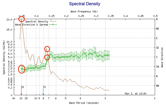
The secondary swell from the south correlates with local winds off the Tas West Coast - the Cape Sorell AWS is unavailable, but Low Rocky Point (some distance south from Cape Sorell) has been recording S/SE gusts 20-30kts all day, which confirms the buoy's direction reading. Note: this information would be unavailable without spectral data (the regular buoy information shows a steady W/SW swell direction for the last 48 hours).
Anyway, this all means that the Hsig values are contaminated with a reasonable percentage of local S’ly windswell, and so the raw values should therefore be viewed cautiously - especially when considering the potential size range that Tp of 20 seconds might deliver.
All that taken into account, and also confirming visually the size of the (same) swell that reached Margaret River yesterday for the WSL with 12ft+ sets on offer at most reefs (bigger at offshore bombies), and I can’t really see any need to adjust Craig’s estimate for a peak in the 6ft range west of Melbourne and 8ft to the east on Tuesday.
Unfortunately, fresh southerly winds will limit surfable options to protected corners and coves. Note: this direction is much more limiting than the classic post-frontal SW breeze, so there really won’t be many waves to pick and choose from - so keep your expectations low. Chances for a brief window of early W/NW winds in Torquay are slim at best. If anything, a more unusual period of lighter winds is certainly possible well east of Melbourne before dawn, thanks to a developing low pressure centre in north-eastern Bass Strait. But it’s not worth working around.
Lighter winds trending E’ly will accompany a slow decrease in swell on Wednesday. Exposed Surf Coast reefs should manage 3-5ft sets (easing to 3-4ft through the day) though quality will be limited; even in the absence of any synoptic wind, conditions will likely be lumpy with residual wobble from Tuesday’s southerly breeze.
East of Melbourne will also slowly improve however the open beaches will probably be too large and unruly in the morning. A freshening E’ly through mid-late afternoon should quickly iron out the lumpy as surf size abates from 6ft+ to 4-6ft.
An active frontal passage through the Southern Ocean all week should maintain 3-4ft surf in Torquay on Thursday and Friday, though the former looks to be spoiled by freshening E/SE winds. They’ll also whip up a secondary short range SE swell for Friday, and with light variable winds under the influence of a building high pressure ridge, should provide the best surf day of the week west of Melbourne, best suited to the beaches thanks to the mix of swells.
East of Melbourne, we can expect good conditions both days with inconsistent sets in the 4-6ft range at the open beaches. In particular, Thursday looks really good with Wednesday’s late freshening breeze expected to produce smooth conditions for the early session.
A new long period groundswell is due to arrive sometime Friday, probably mid-morning onwards (i.e. peaking through the afternoon), originating from a powerful storm near Heard Island yesterday. We probably won’t see a lot more size than already mentioned above, however the odd bigger bomb is quite likely and the consistency should also ramp up too.
This weekend (May 8 - 9)
Early indications are for another strong long period groundswell to arrive this weekend - peaking Sunday - originating from the tail end of the current storm sequence in the Southern Indian Ocean, between Madagascar and Heard Island.
It’s expected to maintain strength as it passes through our far and mid-range swell windows over the coming days (see image below from Wednesday), and following a temporary easing trend on Saturday, should rebuild on Sunday into the 4-5ft range across most of the Surf Coast, with 6ft+ sets at the swell magnets. East of Melbourne should push a solid 6-8ft+ on Sunday.
As for conditions, a weak frontal passage may create moderate westerlies at some point - probably Saturday - but for the most part conditions are looking pretty good overall. Well worth considering for a surf.
I'll firm up the timing and size specifics on Wednesday and Friday.

Next week (May 10 onwards)
There's no sign of any letup of the Southern Ocean storm track for the long term, though we may see less favourable conditions as it pushes closer to the mainland and thus has a more direct influence on our local winds.
So, the first half of next week is on track for large, but windier surf throughout Victoria. More on this in Wednesday’s update.