Fun, warm weekend, cold and windy next week

Victorian Surf Forecast by Craig Brokensha (issued Friday 30th April)
Best Days: Exposed beaches Saturday and for the keen Sunday, selected spots Tuesday afternoon, Thursday morning, Friday
Features of the Forecast (tl;dr)
- Easing SW swell tomorrow with fresh N/NE winds, smaller Sun with stronger N/NE winds, easing into the afternoon
- Large, strong swell building later Mon with a strong SW change, biggest early Tue but easing with strong S tending S/SE winds (outside chance of tending variable)
- New, moderate sized SW swell for Thu/Fri with improving winds
Recap
Tiny, clean waves on the Surf Coast yesterday, better on the Mornington Peninsula but small and slow to 2ft+.
Today our new mix of swells has filled in with great conditions across all locations, coming in at 2-3ft on the Surf Coast swell magnets and 4ft to the east.
This weekend and next week (May 1 - 7)
Today’s mix of swells should peak through today and we’ll see the energy easing from the SW tomorrow, dropping from 2ft on the Surf Coast and 3-4ft to the east. Conditions will be best on the beaches with a fresh N/NE breeze holding all day.
 Winds on Sunday are now expected to hold from the north as a low moving in from the Bight stalls a little. Size wise though we’ll be looking at small leftovers with 1-2ft sets on the Surf Coast, 2-3ft to the east. Winds will be strong from the N/NE, easing into the afternoon so all in all not great.
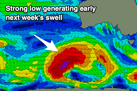
Monday will start small but we’ll see our large, long-period W/SW groundswell starting to fill in through the afternoon, likely peaking overnight and easing Tuesday.
The low linked to this swell has formed just east of the Heard Island region and has been generating a fetch of severe-gale to storm-force W/SW winds through our distant swell window. It's due to be strongest today south-west of WA, weakening slowly while projecting east tomorrow, breaking down Sunday.
A large, long-period W/SW-SW groundswell will result, with it building strongly late Monday afternoon, reaching 4-5ft on dark across the Surf Coast, 6ft to possibly 8ft to the east with a peak overnight. Tuesday morning will likely see the most size with easing 6ft+ sets on the Surf Coast Magnets, 8ft to the east.
Unfortunately winds are still poor with a morning NW offshore Monday (with no decent size) due to give into a strong SW change after lunch as a trough moves east. Tuesday is interesting but not in a good way. A small low forming in the trough may see strong morning S’ly winds easing and tending variable into the afternoon as it retro-grades west. The models are still divergent regarding this little low though and we may just see winds hold fresh from the S/SE into the afternoon.
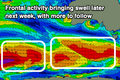 Either way winds look to revert back to the SE on Wednesday and with strength as a high ridges in from the west, squeezing a broad low in the Tasman Sea. This will kick up a low quality SE windswell along with the easing swell from earlier in the week.
Some new, moderate sized SW groundswell should be seen into Thursday and Friday from a strong frontal progression moving in through next week. Pre-frontal W/NW gales will be followed by post-frontal gales, with size to 3-4ft on the Surf Coast, 6ft to the east. Winds look to improve late in the week, swinging E/NE Thursday morning and N/NE Friday morning but we’ll have a closer look at this next week. Have a great weekend!