Slower period with a day or two for the beaches

Victorian Surf Forecast by Craig Brokensha (issued Monday 26th April)
Best Days: Surf Coast tomorrow morning and the Mornington Peninsula for the keen, exposed beaches for the keen early Wednesday, Friday on the beaches and Saturday morning on the beaches
Features of the Forecast (tl;dr)
- Easing swell over the coming days with slowly improving winds for the beaches
- Fun, inconsistent W/SW swell building Thu PM, peaking Fri with N/NE tending variable winds
- Increasing activity through next week
Recap
What a run of surf! Friday's large, pumping and powerful swell eased back into Saturday with clean 4-6ft waves across the Surf Coast, bumpy to the east and small in protected spots.
Yesterday the Surf Coast was still a good 3-4ft+ on the magnets and with clean conditions, back to 3ft today with a reinforcing, mid-period SW swell. Make the most of it as the size and power will continue to ease this week.
This week and weekend (Apr 27 – May 2)
Down, down, down. That's the trend over the coming days with nothing of note swell wise due until late week.
The uptick in size shown on the charts this afternoon and tomorrow is incorrect, with the models combining a new, distant long-period swell with the existing mid-period energy.
Instead, we should see easing 2-3ft sets on the Surf Coast tomorrow with waves around 4ft or so to the east, smaller Wednesday and easing from 1-2ft and 2-3ft respectively.
Conditions tomorrow will be less than ideal with a moderate S'ly across Phillip Island, easing for a period during the morning, more variable on the Mornington Peninsula and light W/NW on the Surf Coast.
 Wednesday will see light N/NE winds early on the Mornington Peninsula, tending N/NW through the morning, and N/NW to the west all morning. Weak afternoon sea breezes are due but with the easing swell options will be limited.
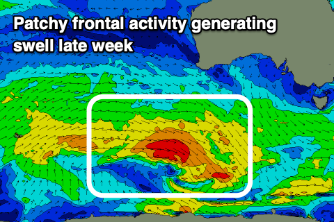
A low point in swell is expected Thursday with N-N/NW winds but no size across any coast. Some new, inconsistent W/SW swell is due later Thursday but more so Friday across the state, generated by a patchy and not overly strong frontal progression that's currently west-southwest of Western Australia.
Patchy fetches of strong to gale-force W/SW winds are being generated through our western swell window, with the activity dipping south-east while moving under the country tomorrow.
This isn't expected to provide much in the way of size but is worth targetting the beaches with inconsistent 2ft to possibly 3ft sets due on the Surf Coast, 3-5ft (4-5ft sets) on the Mornington Peninsula. Winds will be favourable for the beaches all day with a light to moderate N/NE morning breeze, variable NE into the afternoon.
Stronger N/NE winds will kick in Saturday as the swell eases, best early before the size and energy fades.
Longer term there's a bit more activity on the cards for the state with with a mix of mid-latitude storm activity and a strong polar storm developing around the Heard Island region due to bring an increase in swell later Monday but more so next Tuesday. We'll have more details on this in the coming updates though.
Comments
Finger on the pulse CB good work thanks.
Hopefully winter has not come early and blown its guts out before June even comes. Fingers crossed everyone got a little bit over the last 2 weeks of what there will be over the next 5months. :)