Slow weekend for the desperate, hope next weekend

Victorian Surf Forecast by Craig Brokensha (issued Friday 26th March)
Best Days: Surf Coast today, Surf Coast for the keen tomorrow morning and Sunday morning, next weekend onwards
Features of the Forecast (tl;dr)
- Easing W/SW swell tomorrow with fresh NW tending W/NW then W/SW breeze
- Small, weak W/SW swell Sun with W/NW tending S/SW winds
- No decent swell until next weekend
Recap
A peaky mix of swells yesterday, cleanest on the Surf Coast with a W/NW wind and best suited to the beaches with the SE energy.
Today we've got a small, building W/SW swell with a classic autumn morning. Clean on the Surf Coast and a touch bumpy to the east. We should see the swell reaching 3ft on the sets across the Surf Coast swell magnets this afternoon and 4ft+ to the east as winds remain offshore west of Melbourne and unfortunately N/NW-NW to the east. Selected spots should still be OK east of Melbourne.
This weekend and next week (Mar 27 – Apr 2)
This afternoon's swell was generated by a weakening mid-latitude low moving in from the west this week, and we'll see it easing back through tomorrow from 2ft on the Surf Coast and 3-4ft to the east. Winds will be fresh from the NW through the morning, shifting W/NW late morning and then W/SW into the early afternoon.
We've got a slight upgrade in the swell due Sunday, with a weak trough/front pushing in today (stopping the Mornington Peninsula going variable this afternoon) due to produce weak W/SW winds through our swell window today and tomorrow.
Size wise, only a weak 2ft wave is due on the Surf Coast magnets (very low period) with 3ft to maybe the odd 4ft set to the east.
Conditions will remain clean in the morning on the Surf Coast with a W/NW offshore, shifting S/SW into the afternoon.
Monday will be a lay day with a drop in swell and a trough will bring an onshore W/SW-SW change pre-dawn, with onshore winds persisting all day.
There's a slight pulse of W/SW swell showing on the charts for Tuesday but its source is average at best, and we're not expecting to see any size above 2ft on the Surf Coast, 3-4ft to the east. Winds look light and NW through the morning, giving into afternoon sea breezes.
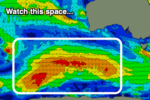 As touched on in the notes earlier this week, the frontal progression firing up towards Western Australia isn't expected to generate much in the way of swell at all but we'll finally see some more significant action developing later next week and into the weekend.
It's still early stages but we should see a strong polar frontal progression firing up south-west of Western Australia, pushing east-northeast towards us on the weekend, generating a much more autumnal looking run of swell. More on this next week though. Have a great weekend!
Comments
It’s gonna have to triple in size to get to 3 ft today..
Very average, low period, west swell. Not the best one to hang hopes on.
All surf cameras today told me one thing :" Mow the lawn !".