East, east, east, not west, west, west

Victorian Surf Forecast by Craig Brokensha (issued Wednesday 17th March)
Best Days: Beaches tomorrow morning, selected spots Friday, Saturday and Sunday mornings, exposed beaches Monday and Tuesday mornings
Features of the Forecast (tl;dr)
- Easing S/SW groundswell tomorrow with E/NE-N/NE winds ahead of sea breezes.
- New SW groundswell building Fri with moderate to fresh E/SE-E winds, stronger SE into the afternoon
- SE windswell building Fri, persisting all weekend
- Similar winds (to Fri) through the weekend with a new S/SW groundswell for late Sat, easing Sun
- Cleaner conditions on the beaches early next week with small, fun swells
Recap
Building surf is size and power through yesterday with the arrival of a building S/SW groundswell under light, variable winds across all locations through the morning creating good to great surf. The Surf Coast built to 4-5ft+ with 6-8ft sets to the east, bumpy into the afternoon as sea breezes kicked in.
Today the swell has dropped fairly quickly, easing from a bumpy 3ft on the Surf Coast, much better to the east and easing from 3-5ft.
This week and next (Mar 18 - 26)
In the wake of yesterday's strong S/SW groundswell we'll see the surf continuing to drop in size and power over the coming days as SE windswell comes into the mix.
The synoptic pattern will see a strong, stationary high moving into the Tasman Sea, extending its arm across us and into the Bight. This will steer a couple of strong storms south-east and away from us while an inland surface trough and troughs in the northern Tasman will squeeze the northern flank, generating persistent easterly winds across us and through Bass Strait.
 Locally, winds tomorrow will be favourable for the beaches again, light E/NE tending N/NE ahead of sea breeze, but with small, easing surf from 2ft on the Surf Coast, 3ft on the sets to the east.
Into Friday our mix of mid-period W/SW swell and SW groundswell are due, generated by one of the south-east tracking storms through our swell window yesterday and today.
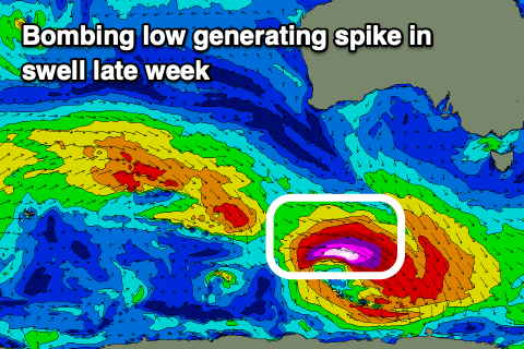
This deepening low is actually actually a 'bombing' low, dropping more than 24hPA in central pressure within 24 hours, with a strong, tight fetch of severe-gale to storm-force W/NW winds being projected unfavourably through our swell window.
The low will move fast as well, which isn't ideal but we should see a spike in swell Friday, peaking through the afternoon and reaching 3ft on the Surf Coast with 4-5ft sets to the east. This is a tricky swell source and while unfavourably aligned and fast moving, we may see sets pushing slightly above the outlined sizes.
Winds on Friday will unfortunately become less favourable with fresh E/SE-E breezes due across all locations in the morning, stronger SE into the afternoon, spoiling the new swell. It'll also add SE windswell to the mix kicking to an easy 3ft across the Surf Coast into the afternoon.
Similar winds are due Saturday and Sunday, with the SE windswell holding throughout the weekend to 3ft or so on the Surf Coast, smaller to the east.
Friday's swell will ease temporarily into Saturday morning back from 2-3ft and 4ft respectively, but another flukey pulse of S/SW groundswell is due later Saturday and Sunday morning from a similar south-east tracking storm. The size from this low looks slightly smaller than Friday's and with the winds, protected spots east of Melbourne will be the pick.
Into next week we should see winds finally start to improve as the high moves east, swinging winds NE on Monday, but with small, fading levels of swell. Tuesday looks fun with an inconsistent, new W/SW groundswell under E/NE winds, but we'll have a closer look at this on Friday.
Longer term there's still no hint of a proper autumn frontal progression through the Southern Ocean but we'll continue to keep an eye on things.
Comments
Well, better than south, south, south I guess
There can't have been too many great waves yesterday given the amount of wonk on the water. Great to have some juice, and it would have been truly great if it was offshore.
Well, mostly good, but did see some images and videos of some great waves.
Cirque du Soleil?
As always.
Still a long way off, but is that the beginnings of a decent swell I see on the the long range forecast. Good Friday.
Aaannndd...it’s gone :(
Nah.....
Must be the drugs.