Last strong swell for a while is due tomorrow

Victorian Surf Forecast by Craig Brokensha (issued Monday 15th March)
Best Days: Tomorrow until the sea breeze develops, selected spots Wednesday until mid-afternoon, exposed beaches Thursday until mid-afternoon, selected spots to the east Friday-Sun
Features of the Forecast (tl;dr)
- Strong, building SW tending S/SW groundswell tomorrow with light S/SE morning winds (variable at times to the east) ahead of sea breezes, easing Wed with morning E/NE winds, similar Thu
- Small mix of swells Fri-Sun with strengthening E-E/SE winds
- Small SE windswell Fri-Mon
- Nothing major next week
Recap
Best Saturday morning with a clean, fun 2-3ft of south-west swell on the Surf Coast, bigger to the east and clean until winds shifted more onshore from mid-morning. Yesterday was poor, cold and onshore in the wake of a cold front, only for the keen.
This morning we've seen the Surf Coast clean back up with a moderate offshore wind and 2-3ft of swell, bumpy and to 4ft to the east. Winds will shift W/SW-SW early afternoon, creating average conditions this afternoon as the swell strengthens a little more.
This week and next (Mar 16 - 26)
Looking at the coming forecast period, tomorrow's SW tending S/SW groundswell will be the most significant for the at least the next week and a half, if not two, so it'll be worth making the most of.
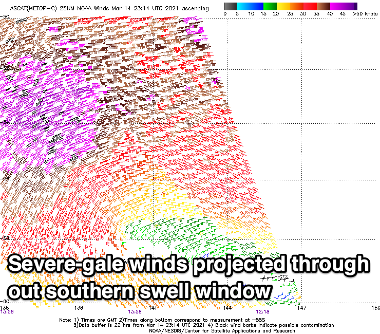
The source of this long-period groundswell is a strengthening polar low on the weekend, with a fetch of W/SW gales from an initial front, reaching severe-gale as the low formed and deepened south-west of Tasmania in our southern swell window.
We'll see the swell arriving through the morning tomorrow, peaking into the afternoon with the Surf Coast due to start around 3ft, building to a strong 4-5ft (6ft sets magnets) with 4-5ft+ waves to the east, reaching 6-8ft into the afternoon.
Winds are workable but not great with a light S/SE breeze due across locations east of Melbourne, tending variable for periods before freshening from the S/SE into the mid-late afternoon. The Surf Coast looks to see light to moderate S/SE winds at dawn, easing and tending light ahead of the sea breezes.
The swell will ease through Wednesday as winds shift E/NE, cleaning up locations east of Melbourne but there might be a bit too much size on offer. The Surf Coast is expected to ease from 3-4ft with 5-6ft sets to the east, though winds should hold until mid-afternoon ahead of sea breezes.
Thursday should see similar E/NE-NE breezes but the swell will be on the way out, dropping from 2ft+ on the Surf Coast and 3ft+ to the east.
From here on we're looking at a run of easterly winds with fun pulses of swell for the beaches but from more distant sources. This will be due to a blocking high moving in from the Bight but maintaining its reach west of us as it continues slowly across Tasmania.
Surf wise, a mix of mid-period W/SW swell and small SW groundswell are due late week, generated by the same system. The W/SW swell will be generated by a mid-latitude low that's currently projecting towards WA, with this front then dipping south-east tomorrow and deepening into a strong polar low.
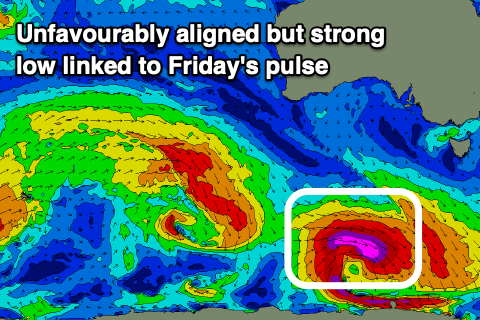 A fetch of severe-gale W/NW winds will be projected away from us, but we should still see a small pulse of swell from this source.
Both swells are due Friday with the Surf Coast only due to see small 2ft to occasionally 3ft sets, 3-4ft to the east with the odd 5ft'er possible.
Small levels of peaky SE windswell should also be in the mix from Friday through Monday owing to persistent, though not overly significant E/SE winds through Bass Strait.
Locally, winds on Friday looks E/SE-E, favouring selected spots, stronger out of the E/SE on Saturday as the swell fades.
Another small, flukey SW groundswell is due later Saturday and Sunday morning from a similar, though weaker, south-east tracking front but winds look to remain gusty out of the E/SE, improving Monday but with a small, peaky mix of easing swells. Size wise we're talking 2ft+ on the Surf Coast and 3ft to the east.
Longer term there's nothing significant on the cards for the rest of next week unfortunately, but we'll have a closer look at this on Wednesday.
Comments
Pretty happy with that 2 hour tulla surf I have booked in...
i reckon it sounds like plenty of fun options for the beaches for most of the week...just a matter of picking the right spot and time!
Strange to see all those E winds at this time of year. Fun waves on Saturday but no real autumn swells yet.
Lingering La Nina.
Light winds and good sets! Looks like most of the state is on da..
Lorne Point cam looked the best I've seen it earlier