Windows for both regions on the weekend, slight upgrade in next week's swell

Victorian Surf Forecast by Craig Brokensha (issued Friday 12th March)
Best Days: Saturday both coasts (east of Melbourne early-mid morning), Surf Coast Monday, beaches to the east late-morning to mid-late afternoon, Tuesday, Wednesday morning on the beaches
Features of the Forecast (tl;dr)
- New SW swell this afternoon, easing tomorrow with a N/NE tending W then strong SW breeze, poor Sun with strong, but easing S/SW winds
- Mid-period W/SW swell building Mon with morning WNW-NW winds, tending variable ahead of a late afternoon SW change
- Strong SW tending S/SW groundswell building Tue with light S/SE winds (possibly variable at times) ahead of sea breezes, easing Wed with fresh E/NE-NE winds
Recap
Conditions became cleaner into yesterday and there was still 2-3ft of swell on the Surf Coast magnets, best on the beaches with 3-4ft sets to the east, remaining fairly surfable into the afternoon and evening.
This morning conditions are cleaner but the swell has reached a low point. Our new SW swell for this afternoon has hit Cape Sorell and we should see it building from midday. We should sets reach 2-3ft on the Surf Coast and 3-5ft to the east with winds remaining favourable until about 2-3pm for the beaches.
This weekend and week (Mar 13 - 19)
This afternoon's increase in SW swell is due to hold into tomorrow morning, easing thereafter. It was generated by a patchy though elongated polar low/front, hence drawing out the peak in size from later this afternoon through tomorrow morning.
We've got a window of better winds for the beaches as well tomorrow morning with a fresh, gusty N/NE'ly, shifting W'ly late morning and holding until a strong, mid-afternoon SW change pushes through. Expect easing 2-3ft sets on the Surf Coast, 3-5ft to the east.
The afternoon change will bring some weak SW windswell Sunday, though only to 2ft to possibly 3ft on the Surf Coast, 3-4ft to the east but with strong though easing S/SW winds.
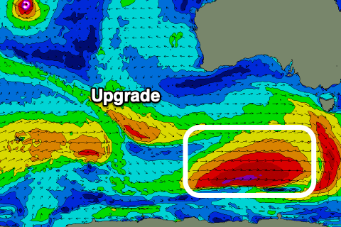 Moving into next week and we've got a slight upgrade in the groundswell due Tuesday, but ahead of this we'll see some mid-period W/SW swell fill in.
The mid-period energy will be generated by pre-frontal W'ly winds passing under WA tomorrow, ahead of a much stronger polar front, come polar low.
Size wise, the mid-period energy looks small in the morning and only to 2ft on the Surf Coast, 3-4ft to the east, building a touch through the day more towards 2-3ft and 3-5ft.
Conditions looks clean all Monday morning with a W/NW-NW breeze, tending variable mid-afternoon ahead of a late-afternoon SW change.
The stronger front talked about the last couple of updates now looks to form into a low, with an initial fetch of healthy W/SW gales now due to reach severe-gale-force around the core of the low in our southern swell window.
We'll see a moderate-large SW tending S/SW groundswell arriving through Tuesday, building towards a peak into the afternoon.
The Surf Coast should build to a strong 4-5ft, with 6ft to possibly 8ft sets on the Mornington Peninsula (smaller and likely 3ft and 4-5ft in the morning), and winds are still looking onshore but workable.
A moderate, pre-dawn S/SE'ly is due to ease and possibly go variable through the morning ahead of sea breezes, with fresh E/NE-NE winds on Wednesday morning as the swell starts to ease back from 3-4ft and 5-6ft respectively.
Make the most of these days of surf, as the outlook will be very quiet into the end of the week and next as we move into a positive Southern Annular Mode (SAM), seeing high pressure dominate our swell windows.
This will bring easterly winds and no major surf (not very autumn like), but more on this next week. Have a great weekend!

+SAM/AAO forecast for the middle-end of the month
Comments
F*ck me. Before you know it, it will be June again and it will have been a full year of below-average seasons on the Surf Coast. The last time we had on-par to above average swell patterns was last autumn when every bloke and his dog were on paid surf-leave, I mean JobKeeper.
Reckon there will be a be a few in the water tomorrow....
Ya reckon?
On a Saturday? On the Surfcoast where 2 out of every 3 cars have boards permanently on the roof or inside?
After yet another week of shit conditions.
Geeeeez........really drawing a long bow there.
Yeh... it was a state the bleeding obvious comment.
Seems everyone a little on edge after our persistent shit run.
I just saw a insta video with 5 on the wave and 2 more considering joining in on the inside...
Those forecast red lines drawn on the SAM graph look like a cat'o'nine tails and it feels like Surf Coast surfers are about to be whipped with it again in the form of more South Easterlies. I actually thought things were on the improve. Wrong.
It's great the forecast keeps changing day by day and swellnet only updates forecast notes 3 times a week.
Value for money
Value for money