New swell tomorrow as winds deteriorate

Victorian Surf Forecast by Craig Brokensha (issued Monday 8th March)
Best Days: Tomorrow morning Surf Coast, Thursday morning exposed beaches, Saturday, Sunday Surf Coast for the keen
Features of the Forecast (tl;dr)
- Good new SW groundswell tomorrow with generally SW tending stronger S/SW winds (light out of the W/NW early-mid morning on the Surf Coast)
- Easing swell with S/SE winds Wed, more variable E/SE Thu and Fri
- New mid-period SW swell for Sat with gusty N/NE tending stronger W/NW winds
- More active surf next week as winds slowly deteriorate
Recap
Winds varied across the coast on Saturday morning, easing and becoming variable around Phillip Island, moderate but also easing on the Mornington Peninsula mid-late morning while remaining onshore on the Surf Coast.
There was still plenty of size about, though the far east locations faired best.
Sunday saw cleaner conditions across the exposed beaches with the swell dropping right back to a fun 2-3ft on the Mornington Peninsula, remaining bumpy on the Surf Coast.
Today the swell has bottomed out and winds are onshore with a weak trough, leaving no quality options.
This week and weekend (Mar 9 - 14)
Tomorrow morning is all about the winds. We've got our new, inconsistent SW groundswell due but will the Surf Coast see a period of early favourable winds before shifting onshore?
The answer is yes, we should see a light, morning W/NW breeze on the Surf Coast tomorrow morning, shifting SW late morning and then S/SW while strengthening.
Looking at the swell and the low that generated it did all its work last Friday and on the weekend. The system has since broken down with the remnants now south-west of us.
A fetch of severe-gales were generated through our medium-range swell window, but over a relatively small area.
Size wise we should see the swell peaking tomorrow to generally 4ft on the sets across the Surf Coast (inconsistent), though the magnets could see the odd bigger one, with 6ft+ sets on the Mornington Peninsula.
The swell will then ease into Wednesday from 3ft+ on the Surf Coast, 4-6ft to the east but with moderate S/SE winds in the wake of tomorrow's change.
Thursday looks a little better than expected late last week with variable E/SE breezes due on the beaches (light E/NE across Phillip Island) with smaller, easing surf from 2ft on the Surf Coast and 3ft+ to the east.
Similar winds are due Friday but the swell will be very slow, weak and at a low point.
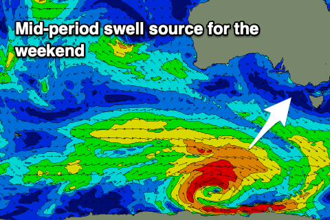 Moving into the weekend, and the mid SW swell pegged last update is on track and so are the offshore northerly winds.
The swell will be generated by a deepening though patchy low developing south of the country tomorrow evening. We'll see a fetch of strong to at times gale-force W/NW winds move through our swell window, with the swell due to arrive late Friday and peak Saturday morning.
Size wise, the Surf Coast looks to come in at 2-3ft, with 3-5ft waves to the east. Winds will be gusty but out of the N/NE during the morning, shifting stronger N/NW into the afternoon. The shift and strengthening winds will be ahead of a strong cold outbreak, with it moving through overnight, with winds reverting back to the W/NW Sunday as another stronger front approaches.
This will be the start of a strong frontal progression with moderate sized+ swell due through early-mid week as winds slowly deteriorate, but we'll have a closer look at this on Wednesday and Friday.