Good run of waves after a couple of average days

Victorian Surf Forecast by Craig Brokensha (issued Monday 1st of February)
Best Days: Thursday, Friday, Saturday, Sunday morning protected spots
Features of the Forecast (tl;dr)
- New W/SW-SW swell for tomorrow but with strong S/SW tending S winds, with a slightly stronger SW swell Wed with E/SE tending SE winds
- Easing SW swell Thu with E/NE tending N/NE winds ahead of late afternoon sea breezes
- Strong SW groundswell for Fri with strong N/NE winds, easing Sat with N/NE tending S/SW winds, smaller Sun with NW tending SW winds
Recap
Nothing too flash on the weekend with clean conditions early Saturday but with a low point in swell, while the inconsistent W/SW groundswell for the afternoon kicked to 3ft+ or so on the magnets but strong onshore winds created poor conditions.
Yesterday was no better with the swell easing under a persistent onshore breeze. This morning we're in between swells but conditions are much cleaner across all locations with a variable offshore breeze. This is ahead of a trough, strengthening onshore and new kick in swell this afternoon, discussed in more detail below.
This week and weekend (Feb 2 - 7)
Following the inconsistent groundswell from the weekend, we've got a couple of better, more consistent swells sources on the cards for the coming days, and winds are also looking more favourable for the beaches into Thursday/Friday with an upgrade in swell.
Later today and more so tomorrow, a new W/SW groundswell is due to fill in, generated by a polar front that developed east of the Heard Island region late last week, but then weakening while continuing to generate a healthy fetch under the country on the weekend.
A mix of mid-period and less consistent SW-W/SW swells are due, filling in tomorrow with surf mostly around 3ft on the Surf Coast, 4-5ft to the east. Unfortunately conditions will be poor in the wake of today's change with fresh to strong S/SW tending S'ly winds tomorrow.
On Wednesday, a slightly better SW swell is due, produced by a frontal system that's currently racing in from the south-west, under the country. A good fetch of strong to gale-force W/SW winds are being generated, on top of the active sea state ahead of it, generating a slightly bigger pulse of swell for Wednesday morning. Size wise the Surf Coast should see 3ft+ sets (swell magnets) with 4-5ft+ waves on the Mornington Peninsula.
 Winds will start to improve as a high moves in from the west, bringing light morning E/SE breezes, giving into stronger, afternoon SE sea breezes.
Thursday looks much cleaner on the beaches with an E/NE tending NE offshore, holding until mid-afternoon before shifting back to the E/SE. We'll be on the backside of Wednesday's SW swell though, with easing 2ft to possibly 3ft sets on the Surf Coast magnets, and 3-4ft range to the east.
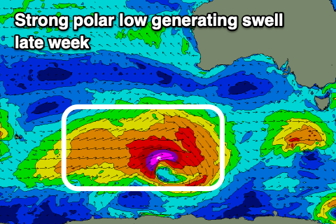
Into Friday we've got a strong new SW groundswell on the cards as a polar low strengthens south-west of WA this afternoon and evening, projecting a fetch of severe-gale to storm-force W'ly winds through our swell window tomorrow before weakening and splitting.
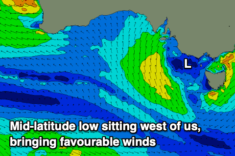 This split will see a cold front projecting up into the Bight, then forming into a mid-latitude low Thursday. What this will help do is bring offshore winds from Friday through Sunday morning as the low stalls west of us.
Looking at the SW groundswell and we should see a peak through Friday to 3-5ft on the Surf Coast, 6ft+ to the east and with strong N/NE winds. Saturday should see morning N/NE winds ahead of a shallow S/SW change as the groundswell eases back from 3ft+ and 4-5ft+ respectively. Sunday will be smaller again with strengthening NW winds ahead of a SW change when the remnants of the mid-latitude low pushes east, across us.
Longer term, another, similar polar low is due to fire up through our swell window late week, generating a new pulse of SW groundswell for Monday/Tuesday but winds look onshore and SW tending S in the wake of Sunday's change. We'll have a closer look at this Wednesday and Friday though.
Comments
Hi Mr CB
I know it's a Long way off but what ingredients do we require for this tropical low which will have potentially found its way under WA 9th of feb to be a better swell generator....as it looks to bolt off to the South East in direction quickly.
From memory these can BOM.