Tricky period with plenty of swell but winds from all directions

Victorian Surf Forecast by Craig Brokensha (issued Friday 29th)
Best Days: Keen surfers Sunday, Monday ahead of the change, possibly Wednesday protected spots, Thursday morning
Features of the Forecast (tl;dr)
- New, inconsistent W/SW groundswell building Sat PM, peaking early Sun but with onshore S winds
- Easing W/SW groundswell Mon with variable N winds ahead of an early afternoon change
- Reinforcing W/SW swell for Tue but with strong SW winds
- Localised S/SW swell Tue/Wed, easing and cleaner Thu AM
Recap
A decent windswell from the east yesterday with surf in the 4ft range across the Surf Coast, 3ft to the east and conditions were cleanest on the beaches east of Melbourne, though the quality not great with the lack of power and energy.
This morning the swell has dropped out on the Mornington Peninsula with the fetch through Bass Strait being aimed more southward, while the Surf Coast still has sets to 3ft but average conditions. Winds should swing NE into this afternoon as the swell continues to ease.
This weekend and next week (Jan 30 – Feb 5)
The start of the weekend isn't anything to write home about with a low point in swell along with SW winds (early light W/NW across the Surf Coast). A trough will bring a fresher S/SW change through the afternoon as our new, long-period and inconsistent W/SW groundswell fills in.
This swell has filled in strongly across Western Australia today and looking at the size, I'm now confident there'll be a few bigger sneakers in the mix at its peak in size early Sunday. The swell was generated by a strong polar low in the Heard Island region earlier this week, with it due to arrive tomorrow morning, building strongly into the late afternoon and evening. We may see sets push 3ft+by dark tomorrow on the Surf Coast, 4-5ft+ to the east but with that strong onshore wind.
Sunday morning should see inconsistent 3-4ft waves on the Surf Coast, 5-6ft to the east, but with those bigger cleanups at time, easing into the afternoon. Monday will be smaller and back to generally 2-3ft on the Surf Coast in the morning and 4-5ft to the east.
In the wake of tomorrow's change winds will weaken but remain moderate out of the S'th Sunday, tending S/SE later in the day. It won't be great but there'll be options for the keen.
 Monday morning looks cleaner as winds shift variable N'th, cleaning up conditions. Early will likely be morning sick before conditions straighten out ahead of an early afternoon S/SW trough and change.
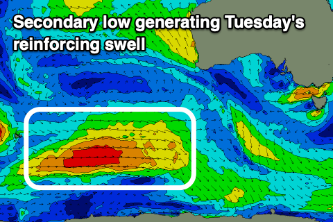
Into later Monday afternoon and more so Tuesday, our reinforcing W/SW groundswell is due to fill in, generated by a secondary, more distant polar low firing up the back of the strong system linked to the weekend's swell. This low is currently weakening south-west of Western Australia but will maintain a fetch of strong, broad W/SW winds through our swell window on the weekend, followed by a secondary front pushing through Sunday/Monday.
Size wise, we should see a mix of inconsistent W/SW groundswell and mid-period SW swell Tuesday/Wednesday to 3ft+ on the Surf Coast and 4-6ft to the east but the secondary front will bring strong SW winds and a localised S/SW swell (into the afternoon) as it forms into a low, projecting S/SW gales up into us.
We may see winds steer back to the W/SW-W on Wednesday depending on the positioning and movement of the low, with the size potential out of the S/SW being around the 4ft range on the Surf Coast, 6ft+ to the east.
Cleaner conditions look more likely Thursday as the low weakens as a secondary low pushes slowly up from the south-west, swinging winds variable out of the north, though we'll have to review this next week as there's a lot of instability and uncertainty in the forecast.
We're likely to see a moderate sized S/SW groundswell next weekend from a strong frontal system dipping south-east from the Indian Ocean, but more on this Monday. Have a great weekend!