Nothing great with swells peaking as winds go onshore

Victorian Surf Forecast by Craig Brokensha (issued Monday January 11th)
Best Days: Today on the beaches, Wednesday morning on the beaches, Friday morning on the Surf Coast
Features of the Forecast (tl;dr)
- Small, building W/SW swell Wed with N/NE winds until early afternoon, easing Thu with a dawn W/NW breeze
- Building W/SW groundswell Fri with fresh W/NW winds ahead of a strong, late morning SW change
- Poor, onshore surf Sat-Tue
Recap
Fun waves across the exposed beaches through the mornings with light winds, biggest Saturday, smaller yesterday. The Surf Coast was fairly average, best Saturday morning for the keen.
Today conditions are clean across most breaks with a hot offshore wind and small, new inconsistent mid-period swell. It's a bit under expectations but offering fun 3ft+ sets across the Mornington Peninsula and 2ft to the west. Winds look to hold until around 7:30-8pm so make the most of the clean conditions.

Inconsistent, but a good, fun size
This week and weekend (Jan 12 - 17)
Similar sized surf is due tomorrow across both regions but this evening's change will leave strong, though easing S/SW winds, tending S'ly through the afternoon. This will create choppy, average conditions, improving a touch through the afternoon.
Wednesday morning will start small and slow, but a new, small, inconsistent mid-period W/SW swell should build through the late morning, peaking into the late afternoon.
The source of this swell was a relatively weak but persistent frontal system firing up around the Heard Island region on Friday evening.
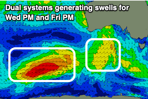 A fetch of strong to near gale-force W/SW winds were initially generated, with the front now weakening under WA, moving east as a trough though still generating a fetch of strong SW winds.
The swell should looks smaller than forecast on Friday with the Surf Coast building from 2ft in the morning to 2-3ft through the late afternoon, and the Mornington Peninsula 3-4ft, building to 4-5ft through the late afternoon. Morning, light N/NE winds should hold until early afternoon, giving into sea breezes ahead of a late and stronger SW change. Therefore get a surf in before mid-afternoon.
The swell will ease into Thursday morning with an early W/NW breeze, shifting stronger S/SW late morning.
We've got a better groundswell due into the end of the week from a stronger front, come low that's formed around the Heard Island region. A better fetch of W/SW gales are being generated, projecting east-northeast through our western swell window towards the Bight while weakening rapidly.
The swell will be inconsistent but fun in size, building Friday, peaking into the afternoon, then easing Saturday. Also in the mix will be a mid-period SW swell from a weak trough moving in Thursday, but not above the size of the groundswell. The Surf Coast should build from 2-3ft in the morning to 3ft+ later in the day, 4ft+ on the Mornington Peninsula, up to 4-6ft through the late afternoon.
Winds look favourable and fresh out of the W/NW through the morning, but the trough will bring a strong SW change late morning, persisting Saturday as the swell eases. There's an outside chance of a dawn W'ly Saturday morning but we'll review this Wednesday/Friday.
Unfortunately onshore winds look to dominate the weekend and early next week as a strong, slow moving high pushes in from the west, with frontal systems skirting around its south-eastern flank due to generate pulses of S/SW swell. More on this in Wednesday's update.
Comments
Tiny 'n weak, even on the most exposed surfcoast beaches but at least the waters nice and warm. Managed to wear a 1.5mm long-sleave wetty top 'n boardies and didn't get cold for 1 1/2 hours. Perfect weather for snorkelling in the bowl :)
Just wanted to ask the question about tidal discrepancies - Eg predicted vs actual from some anecdotal evidence experienced. Headed down to the usual low tide reef exactly on the afternoon low which we have been following for the past week. The afternoon tides have been reasonably low at around .2m and yesterday was the same prediction however the tides were approximately 30cm above the predicted low tide.
The usual rock finger to jump off was well and truely submerged and all the usual boils were well underwater. Very strange.
The low tide level was a total outlier given the consistency of tides and heights over the prior days.
A few questions;
1. Did anyone else observe this yesterday be it in Victoria or elsewhere?
2. What could be the reason/s behind any variances
3. Is this something that can happen occasionally or regularly? When I think back about i recall times when the tides have done strange things from predicted. Again what would be the possible reason/s for this?
If anyone can chip in with any feedback, knowledge or advice that’ll be great
Great question and observations.
It could be a couple of things.. Coastally trapped waves moving in from west to east can elevate and lower the sea level, and the source of these are usually strong cold fronts and bursts of westerly winds piling up water under the country (through the Bight), though we haven't seen this over the past couple of weeks.
Then there's the inverse barometer effect which basically sees the water level lift under low pressure by 10cm per 10hPa, or drop with higher pressure. Though again there have been no major pressure influences across the region, and to get 30cm you've got to have 30hPa of lower pressure across the region.
https://www.swellnet.com/news/swellnet-analysis/2016/04/19/inverse-barom...
This tide gauge at Port Welshpool which isn't well placed regarding where you may have surfed did pick up a 14-20cm + residual last night on the high, and this morning's low... The cause is unsure though and other observations around the state are sparse.
Thanks Craig and no problem at all. Interesting stuff. It had a mates and my head spinning for a bit and leading into some strange conspiracy theories eg. Had the moon blown up or had the earth tilted off its access haha
It may have had something to do with coastal trapped waves - there was a small amount of easterly swell been pushed into the headland - almost like a current, in effect filling rock pools and crevices which shouldn’t have been filled based on the predicted tide, however the water was generally very slack in aside from when occasional sets rolled through from the SW.
The same easterly push occurred the day before (probably stronger as there was more easterly chop evident on the face). On both days this easterly push / chop moderated as the afternoon wore on.
There was a massive change in weather yesterday Eg. 30 deg + by 10am pushing mid to high 30s throughout the day. Most other days have been low twenties.
Of course the Gippsland ports obs! Totally forgot about that one. Interesting to see the Welshpool obs were barely effected yesterday afternoon but are so today. Are there any other Vic tide obs available that you know of? Would be interesting to get some west coast obs if available. Thanks for the info and detailed reply, the knowledge is great and it’s much appreciated. I’ll keep an eye on everything today
Very interesting, could maybe have been piled up from the north-west wind through yesterday as well? But most likely a coastally trapped wave moving through. And no, unfortunately there aren't any other tide data stations that I've searched for.
Thanks Craig. There were no other weird tides for the remainder of the week (not overly notable anyway) so was definitely a strange outlier. Super interesting and a learnt a bit along the way. Cheers. Bummer about the limited data stations, it would be interesting to have multi buoys & ocean obs along the Vicco coastline similar to the manly hydraulics setup. On a side note you also have to wonder if tidal cycles effect ChlorineSurf. The conditions seem reasonably variable there also, sometimes it drains more then other times
Chlorine Surf?
UrbnSurf / Tullatub ;)
Aghhh, haha!
I knew it

On a side note what draining low tides we have at the moment... The last hour plus of the drop any swell we are getting is all but disappearing... however there is a flip side
Urbansurf tide times?
What's Tullamarine best on? High or low?
Dropping mid to low without a doubt