Protected spots followed by exposed spots

Victoria Forecast by Craig Brokensha (issued Monday 7th December)
Best Days: Protected spots early tomorrow and Wednesday morning, exposed beaches Saturday, Sunday and Monday mornings
Recap
A great day for the beaches on Saturday with clean conditions and a mid-period swell easing from 3-4ft across exposed breaks, 2ft to the west. Sunday was clean but tiny on the Surf Coast, poor to the east while some new swell kicked into the afternoon from a mid-latitude low edging in from the west.
Today most locations started a bit slow with the high tide and mid-period W/SW swell, but the swell magnets kicked nicely mid-late morning with clean 4ft+ waves as the swell strengthened a little and the tide dropped, much smaller in protected spots.
This week and weekend (Dec 8 - 13)
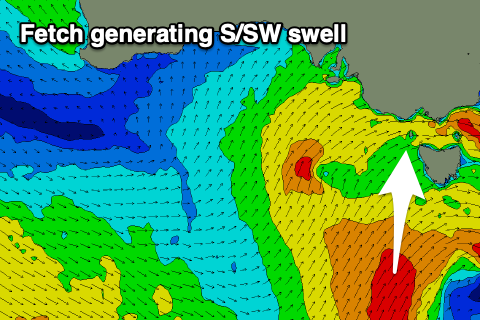
The slow moving mid-latitude low linked to today's W/SW swell has weakened on its western flank is it moves across us today, but on its southern flank we're still seeing a good fetch of strong to gale-force S/SW winds aimed through our southern swell window.
 Swell from this source is due later tomorrow, peaking overnight, easing Wednesday. So what we can expect tomorrow is easing mid-period W/SW energy from 3-4ft across the Surf Coast swell magnets, smaller elsewhere. The Mornington Peninsula should ease back from 6ft on the sets.
The new S/SW swell looks to come in at 3-4ft on the Surf Coast late, easing back Wednesday from 3ft+, with 4-5ft sets to the east. There looks to also be some weak SW swell in the mix from a weak front moving through our swell window tomorrow, softening the easing trend.
Winds tomorrow will be best for protected spots and W/NW early, shifting SW mid-late morning, while a moderate W/NW-NW breeze is expected to hold until midday Wednesday ahead of a strong S/SW change as a trough/cold front slides in.
In the wake of the trough/front on Thursday, winds will be poor and strong from the SW tending S. The swell will be at a low point in the morning as well, but a new mid-period and moderate sized S/SW swell should build into the afternoon, peaking Friday.
The swell will be produced by a broad and elongated fetch of strong S/SW winds being projected towards us, with Friday seeing surf to 3ft+ on the Surf Coast, 4-5ft+ to the east.
A slow moving high behind the trough will continue to create poor conditions with strengthening S/SE winds on the cards Friday, likely tending more E/NE on Saturday as the mid-period swell eases. This should create fun waves on the beaches (easing 4ft sets), clean again Sunday morning but small.
Longer term there's nothing too major at all on the cards as the positive Southern Annular Mode event keeps the westerly storm track subdued and close to Antarctica. There is one fun pulse of SW groundswell likely Monday with favourable winds, but we'll have a closer look at this Wednesday.
Comments
Hey Craig, general Vic question. Is Flinders Island the reason we don't get any decent SE groundswell near Melbourne? Thinking there must be storms to our SE that would get pretty strong but does that group of islands and Wilson's Prom (and probably Tassie itself) block the swell from getting to us? Cheers Dan
The Surf Coast would be the only coast to receive swells from the east to south-east, but looking at the position of Flinders and the Prom, I've drawn where swells could originate to get past these land features and you can see, none would get in. If it were huge from the east you'd probably see small sets diffracting in up to the Surf Coast, but there's all those other island to pass through as well.
If Flinders was removed.. the swell window would be limited and only from east to south-east, but way more open and active.
Thanks for the detailed reply! Looking at the other side and major obstructions - King Island the main one. Sometimes when in the water it feels like there are waves coming from two distinct directions, one more W and one more S. I'm guessing that's more likely just different swells (though possibly projecting from different sides of King Island) rather than the one swell getting split either way by King Island?
Should probably pay more attention and see if it feels the same next time the swell is really west.
Never forget the SE swell of ‘16. Possible to hindcast Craigoss? Assuming we nail down that specific Sunday..
Got the dates?
Ill try chase up. Ive also got another one. Nov/Dec ‘13. Hopefully be able to chase up a date but I can vividly remember Pt. Nepean buoy - 144 degrees @ 12 secs. Portsea had lines going sideways. Got waves at spot that we will forever be chasing the dragon with.
If you can hindcast, surely a quick browse of Nov/Dec 2013 should offer some dead giveaway? Im thinking late Nov
Hmm, need a specific date otherwise it's too hard to find quickly.
I can see one source between the 22nd and 25th of November. Got an exact day for me?
Try 31/01/16 Craig. I've got pics. A rare day that only lasted maybe 3-4 hours before the swell straightened out and went back to the usual 4-6ft closeouts. Prior to that there were solid overhead peaks throwing up all over the place.
I got some sick pics too, very good day
Hey Geek I think you are talking about a different day than the bone, the days your talking about was a peaky 5 ft off shore swell from the sse and was pumping every where from Gunna to the heads.
Bone and a couple of deep fryers surfed a mystical beast that is usually fat, slow and easy to slay. But apparently on this day it was slabbing angry beast, not for the usual cowards of the near by cove. The swell was lined up from the se with a light west wind, and beaches were no good.
Finbobb plumb bobbed it right on the head
It was after work. I still can’t remember the exact date. What could narrow it down was that we had this SE swell but we had a almost glassy Westerly wind!!
Hey Craig,
Was further down the coast - just past Lorne - on the weekend. Saturday was very weak and peaky knee high, which could be expected. But Sunday morning there were clean lines of ground swell with the odd slightly head high or so set around mid tide in the morning. After that it seemed to drop away a bit.
On Sunday morning it felt like we were catching the front edge of the swell but it never seemed to fill in across other parts of the surf coast.
Was this just some sort of freak in the swell where some of the leading edge from today's swell refracted in around Cape Otway? Or just some rogue sets from an unrelated event?
Thanks!
Hey Anthony, hmm that's a tough one to answer but from memory there were no other swells in the water at the time. Sounds like some rogue sets from an underlying background swell.
Thanks Craig - yep after I posted that question I thought it may be a little obscure. Anyway I snagged a few of those mystery sets before they went away.
Hey Craig, as an absolute novice when it comes to understanding the reports and forecasting I was wondering if you recommend any reading I could use to bring myself up to speed with some of the terms and patterns?
Cheers.
Hey, how basic are we talking. Do you understand offshore/onshore winds, swell directions, difference between a left and right hander?
Lefts and rights yep, on shores offshores yep, periods yep - things the swell directions and degrees not so much and terms like ‘front edge of a swell’ and ‘fetch’ just go straight over my head.
The Weather and Climate of Australia and New Zealand
A.P. Sturman, N.J. Tapper 1996
Oxford University Press
;)