Great weekend, mixed next week

Victoria Forecast by Craig Brokensha (issued Friday 18th September)
Best Days: Saturday, Sunday, Monday Surf Coast, Surf Coast Wednesday and Thursday
Recap
Conditions weren't too bad yesterday morning with a light to moderate onshore breeze and drop in size from Wednesday, best across the Surf Coast before winds strengthened into the afternoon.
Today winds are improving for the beaches and swinging more offshore with 4ft sets on the Mornington Peninsula, choppy and junky to 2-3ft on the Surf Coast reefs. We should see the beaches continue to improve ahead of late afternoon sea breezes.
This weekend and next week (Sep 19 – 25)
The weekend is shaping up as good one on the beaches with a strong new S/SW groundswell and offshore winds.
We'll see a mid-latitude low that's currently across South Australia slowly moving in from the west, squeezing a high in the Tasman Sea, swinging winds around to the N/NE-NE tomorrow morning, shifting back to the E into the afternoon. Sunday will then see stronger N/NE winds persisting all day east of Melbourne as the low edges closer, while the Surf Coast should see winds tend more N/NW from late morning.
Swell wise, the polar fetch of W'ly gales linked to our new S/SW groundswell have now pushed east and under Tasmania, with the swell spreading northwards towards us. The swell should arrive overnight and a peak is likely through the middle of the day/afternoon tomorrow to 3-4ft on the Surf Coast and 4-6ft on the Mornington Peninsula.
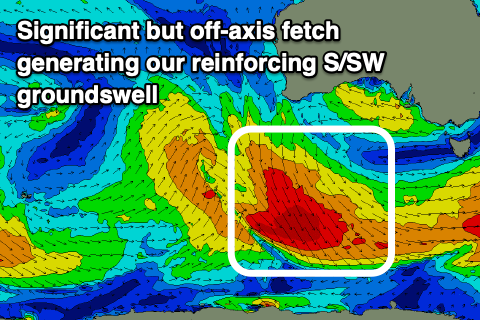 Sunday morning looks a little smaller and easing back from 3ft on the Surf Coast, 4-5ft to the east, but into the afternoon a reinforcing S/SW groundswell should fill in.
As discussed in Monday and Wednesday's notes, the source of this swell isn't great or well aligned. A broad and significant fetch of NW gales are moving in on the back of the sea state generated by the polar front ahead of it, and even though poorly aligned we should see some fun swell spreading out radially up and into us.
It'll be less consistent but the Surf Coast should hold 2-3ft into Sunday afternoon, 4ft+ to the east, easing from a similar size Monday morning.
Winds will shift W/NW early Monday morning as a trough shifts in from the west but we'll likely see them revert back to the N/NW through the morning, freshening into the afternoon.
Now, this low still looks average regarding swell production with all of it's swell generating fetch sitting north of us and in the Bight through the weekend and even Monday.
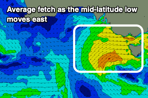 As the low finally moves across us Tuesday afternoon and Wednesday, a weak fetch of W/SW winds will be generated in our swell window, kicking up a low quality, mid-period W/SW swell Wednesday, easing Thursday.
At this stage it looks like the Surf Coast will build to 3ft to possibly 4ft later Wednesday, smaller Thursday and easing along with strong NW tending W/NW winds on the former and W/NW tending NW winds on the latter.
Longer term the outlook is a little unsure but mid-latitude storms look to dominate which isn't the best outcome. More on this Monday, have a great weekend!
Comments
Got me like https://m.
Alas. I feel i must heed to my rule number one - never get excited..
Lol! Too funny, what a bizarre video clip. I only know that song from the 3 degrees surf movie which I must have watched 500 times.
10 points sir. Trivial fact - First DVD I ever bought!
" and even though poorly aligned we should see some fun swell spreading out radially up and into us."
Looking at it, looks like 90 degrees from the source direction. That's weird as. Not complaining.
Yeah nuts eh!
But, Great Circle Paths..
If it weren't for the strength and movement on top an active sea state we'd hardly see anything. Have to kinda of imagine how much size we would see if it was perfectly aimed, then seeing as it's half off axis, take points (size) away accordingly.
It's well aimed for Tahiti...
But seriously Craig that's 8000km away? Surely it'll decay in size, consistency and strength, imagine the lulls......45 + minutes between set's and what sort of size would you actually expect too see the location?
Oh for sure, but it won't be that inconsistent, probably the order of 10/15 minutes between sets, just making a point. Cloudbreak gets plenty of swells from similar sources and they aren't that inconsistent.
You ain't missing anything Covid dogs!.....(joking) ;) Sure there's a nice underlying swell but there's an ugly easterly wobble and surface chop from the SE. It'll need a straight offshore wind to iron out the imperfections before it's worth getting excited about.
Got a Bay swim in this morning. Was like a 4-5ft offshore day on the coast.
Complete glass off, clear water and a bit of warmth in the air.
Yes Bnkref, got a Bay paddle in Sat morning for some fitness. Super glassy!
Well Craig, that 'radially' swell punched above it weight, it pumped out some really nice sets for quite a few hours today.
Great call.
I’ll second that..
Significant period 16s, peak period 18.2s @ 6pmish
Late arvo session was real good around here.
Great to hear. How big this arvo?
Hi Craig, I'd call it 3-4ft and consistent. There was really good power for it's size. Last 2 hours of light with the tide dropping right out was one of the best medium sized sessions I've seen. Lots of crew completely missed the swell.
Agree
Craig was solid on the peninsula few sneaky sets.
Surfed a rare bank
3 young blokes came out
Holding 5 ft to 6ft
One solid set shut down on us solid 8ft Thick lipped 3 on the head
I duck dived the young blokes who surf some of the heavy reefs round here through their boards.
Two of their leg ropes broke and the other guys board was snapped clean in half.
Bigger than everyone anticipated.
Was this out off chickens
nah
nose rings
best under called surf in years. so much fun :)
Shows the value of the forecaster notes. Well worth what we pay for them. Glad I waited till mid arvo for my surf yesterday.
I watched the Cats playing like busted arses in the first half against the Swans and had a look at the surf at half time with the Catters 2 goals down. Was just before 5pm and couldn't believe how much it had improved in a couple of hours with not many crew on it. Ruler edge 3ft with a few bigger ones and 10 -15knt offshore.
Hit record for the 2nd half and went surfing till dark and had a ripper. Came home to cold beer and watched the 2nd half with the Cats getting home in the last couple of minutes to secure a top 4 finish!
Win / Win
Great timing for the swell too. It peaked, right when the cats were playing. That kept the rabble out of the lineup.
Wow, great to see it over-performed and from such a unique swell source (those NW gales).
Yeah Craig it was impressive. Must admit I looked at the charts you posted, mentally pictured the NW fetch going down and hitting Antarctica anyway. I'm still coming to terms with how it great circled back up.
It had the longer period too, there's one spot grom and I froth for that needs the longer period. So question: What's the average period for a swell (mostly around SW) hitting the surf coast? 14s? I know a larger period often precedes groundswells, but how often do we get a longer period - say 16 to 18s - within a groundswell?