Winds improve and strengthen along with the swell

Victoria Forecast by Craig Brokensha (issued Wednesday 15th July)
Best Days: Beaches tomorrow, Friday and Saturday, Sunday
Recap
A slight increase in new W/SW groundswell through yesterday afternoon reaching 3-4ft on the Mornington Peninsula and 2-3ft across the Surf Coast, with workable conditions on the former, poor on the latter.
Today we've got similar sized sets to 3-4ft on the Mornington Peninsula, 2ft to occasionally 3ft on the Surf Coast and with slightly better conditions for the beaches.
This week and weekend (Jul 16 - 19)
These notes will be brief as Ben's on annual leave.
We'll see conditions continue to improve across all locations tomorrow with a variable morning breeze likely to tend locally offshore but the swell will be small. We're looking at inconsistent 1-2ft sets on the Surf Coast with 3ft to occasionally 4ft waves on the Mornington Peninsula.
Into the late afternoon though our new inconsistent W/SW groundswell is due but this will be with SE sea breezes, and sets should push to 4-5ft on the Mornington Peninsula.
A peak is still expected on Friday morning with infrequent 2-3ft sets on the Surf Coast swell magnets and 4-5ft+ across the Mornington Peninsula along with great N/NE winds, persisting all day as the swell starts to ease late.
 A temporary low point may been early Saturday morning ahead of our slightly stronger and very long-period W/SW groundswell building through the morning, kicking strongly into the afternoon and easing slowly Sunday.
This swell has been generated by a significant storm around the Heard Island region, on the back of the storm generating Friday's swell with a distant fetch of severe-gale to storm-force W/SW winds projected through our swell window.
The Surf Coast is unlikely to drop below an inconsistent 2ft Saturday morning, building back to 3ft later in the day across most locations with 4ft sets on the swell magnets. A similar trend is due on the Mornington Peninsula, building from 4ft to 5-6ft late.
Sunday morning will likely see similar sized and very inconsistent surf, then easing into the afternoon and smaller Monday.
Winds are still expected to strengthen Saturday out of the N-N/NE favouring selected spots, and then holding strong from the N-N/NW Sunday morning before shifting N/NW into the afternoon.
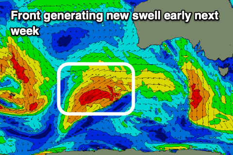
These strengthening winds will be ahead of mid-latitude front come low that is still unresolved regarding its track. EC has it pushing across us while GFS has it tracking north.
Either way the earlier stages are expected to generate a new W/SW swell for Monday/Tuesday but the winds are up for grabs depending on where the low tracks. More on this Friday.
Comments
I accept this
Ha, love it!
Hey Craig, is there any particular weather influence that's causing every weather system to be peaking in WA and then cutting off or just sliding past the SE of Aus? I know that the SAM is a major influence but even that has been mostly negative since late June but still no real meaningful swells to speak of. Even the models have struggled more so than usual to form any alignment over a few days out. It's been a strange winter down here
Agreed, worst June/July on the SC i've ever seen
And a nice little period on the east.
Swings and roundabouts but not your typical June July hey
it's the summer like high pressure systems that keep dominating australia every week that is pretty much blocking storms/swell for victoria. it's been happening every week since that last east coast low that came through on may 20th. We never had a summer this year but now our winter is looking like summer. It's great being able to score the reefs then the beachies down south every week.
Yeah Vicco11, not sure why we've seen the current unfavourable setup for so long but will try and get to the bottom of it. Could be a few factors linked to sea surface temperatures in the Indian and Pacific.
Unfavourable? Only for about 100km of coast :-D
Just a heads up city crew. “Chief health Officer has updated stay at home orders so you can’t leave the house if it involves unreasonable travel”. Vague but i would be very cautious if you are driving to Gunna from Brunswick.
there were cops checking at two roadblocks on southern end of MP on Wednesday, scaning licenses and asking what your reason for being out was. Not sure if anyone got fined but saw a couple of cars get turned around.
Thanks for the update. Due to the lockdown I am grounded :-(.. No surfing or XC skiing. :-((