Building westerly swell but without much power

Victoria Forecast by Craig Brokensha (issued Wednesday 24th June)
Best Days: Keen surfers later Friday, Saturday, Sunday, Monday morning
Recap
Yesterday's onshore change didn't come in as strong as expected through the morning and there were workable waves for the keen with a mix of swells to 2-3ft on the Surf Coast and 3-4ft to the east, easing back a touch today with lighter and more variable winds.
This week and weekend (Jun 25 - 28)
Today we've got an inconsistent and long-range W/SW groundswell mixed in with some localised close-range swell and we'll see both easing off through tomorrow as winds swing back to the NW. This will favour the Surf Coast but it looks to only be small to tiny and easing from 1ft to possibly 2ft on the swell magnets, with easing 2-3ft sets on the Mornington Peninsula. Conditions will deteriorate through the day as well with winds swinging to the W after lunch.
We then look to the building mid-period W/SW swell through Friday ahead of a peak Saturday.
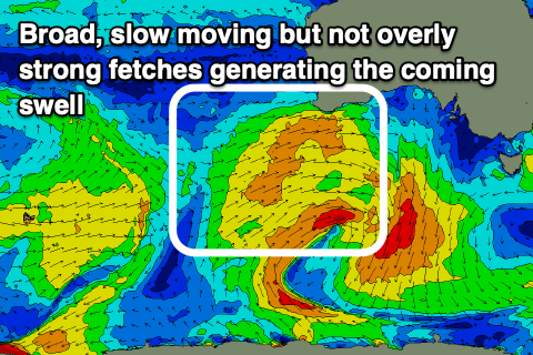 The mid-latitude low linked to this swell is currently just south of WA and we're seeing a broad but not overly significant fetch of strong W/SW winds aimed through our western swell window. The low is stalling but we'll see a cold front pushing slowly east away from the low this afternoon and evening, producing a weaker fetch of 20-25kt W/SW winds through our immediate westerly swell window tomorrow. The front will then cross us into the afternoon bringing that W'ly change.
This will produce a small and weak increase in W/SW swell for Friday morning ahead of the mid-period energy which should build later in the day but peak Saturday.
Size wise the Surf Coast should build from a small and weak 1-2ft on Friday morning, possibly reaching 2-3ft by dark, with building surf from 3ft to possibly 4ft on the Mornington Peninsula, more to 4-5ft by dark.
Saturday should provide the most size and power with surf mostly around 3ft on the Surf Coast, 4-6ft to the east, easing later in the day and then down from 2ft+ and 3-4ft respectively Sunday.
Locally winds on Friday will be out of the W/NW through the morning, shifting W/SW-SW around midday but without any major strength so there should be some OK options later in the day.
Saturday now looks cleanest on the Surf Coast with a light to moderate W/NW breeze through the morning, giving into weak sea breezes. So unfortunately the beaches won't be ideal with better conditions in more protected spots. As the swell eases Sunday winds will persist our of the NW-N/NW through the morning, likely more variable into the afternoon opening up options east of Melbourne.
Now, as touched on Monday, most of next week will remain void of swell owing to an upper level block moving in through the weekend though winds will be favourable and out of the northern quadrant. The only issue is that the storm track will be focussed north and into Western Australia, out of our swell window. No decent swell is due for the beaches, with background energy unlikely to top 2ft to sometimes 3ft, tiny on the Surf Coast.
Of greater significance is a strong cold outbreak due in the wake of the upper level block as a strong node of the Long Wave Trough moves in from the west late week. This will bring the frontal activity from WA closer and then over us bringing building swells with plenty of wind, but to what size will have to be looked at over the coming updates.
Comments
Craig you need another holiday. Bring Ben back to give us a decent forey.
Gotta admit, it's always the case just after handover but Craig always provides after a slow start ;)
Haha, seems that way eh!
That storm late next weekend is a shoe in. Got the wave pool on sat :(
The last few days it's looked great for the east on Saturday. 5-6ft and NE.
Looks like it was just a mirage.
Any chance for a decent swell the following week? I’m hoping we are not looking at 2 weeks of flatness for school holidays.
Torquay is about to go balistic again. Gonna have to go down south to get away from the crowds
33 new cases today, school hols lockdown coming surely
Fuck the school holidays and the stupid increase in already crowded line ups that it brings.
They only just went back to school a couple of weeks ago FFS!