Slight improvement for the weekend, potential next week

Victorian Surf Forecast by Craig Brokensha (issued Friday 5th June)
Best Days: Saturday morning, Monday morning, Tuesday, later Wednesday, Thursday morning
Recap
Wednesday afternoon’s large spike in S/SW groundswell eased back through yesterday from a slightly bumpy but improving 3-5ft on the Surf Coast and 6ft+ to the east.
Today the surf is smaller but cleaner across the Surf Coast with easing 3ft waves, bumpy and workable to the east to 4-5ft. A new SW groundswell maye be seen later today, halting the easing trend as winds shift west-northwest
This weekend and next week (June 6 – 12)
We’ve got an improvement in the wind forecast for the weekend with a surface trough that’s expected to move in from the south now due to be weaker and stall tomorrow morning. This will bring light W/NW winds to most regions, holding until about midday across the northern regions of Bass Strait before the onshore change moves in.
 We’ll see later today’s SW groundswell (generated by pre-frontal NW tending W/NW winds) holding 3ft on the Surf Coast and 4-5ft to the east, but a new S/SW groundswell is due to build through the day. This was generated by a better post-frontal fetch of gale to severe-gale W/SW winds and should reach 3-4ft on the Surf Coast into the afternoon, 5-6ft to the east.
Sunday still looks poor with moderate to fresh S’ly winds and easing surf from 3ft and 4-5ft respectively.
Monday is a little tricky wind wise but we’re likely to see variable breezes in the morning and weak afternoon sea breezes.
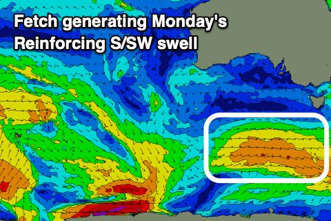
A reinforcing mid-period S/SW swell is still on the cards, generated by a weaker polar fetch of strong W/NW-W winds trailing the polar low linked to tomorrow’s swell. There’s no change to the expected size with 3ft+ waves on the Surf Coast, 4-5ft to the east.
 Tuesday will improve across the beaches as the S/SW swell eases with a moderate N’ly breeze (N/NW on the Surf Coast), shifting NE and more variable into the afternoon.
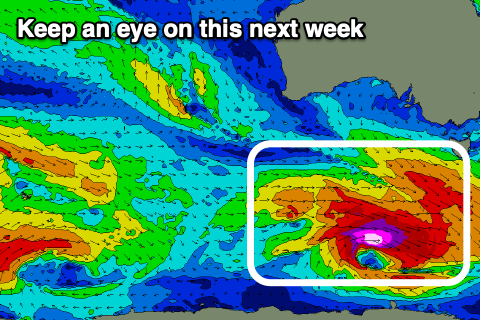
Our next increase in swell is from one of the strengthening polar storms pushing around the southern flank of a broad high moving in from the west next week. We’ll see a great fetch of severe-gale to storm-force W/NW winds generated in our south-western swell window.
A moderate sized SW groundswell is expected to arrive later Wednesday and peak Thursday. Winds are little up in the air but a morning W/NW’ly is likely, possibly giving into a S’ly change as a trough moves through. More on this Monday, have a great weekend!
Comments
Howdy Craig/anyone that can be bothered. Are we still on track for some local northerlies tomorrow morning (Monday)? Or is it gonna be all south easterlies?