Plenty of swell on the way but mostly onshore

Victoria Forecast by Craig Brokensha (issued Wednesday 18th March)
Best Days: Possibly Surf Coast early afternoon tomorrow if the swell arrives early, Saturday and Sunday mornings keen surfers protected spots
Recap
Pumping waves across the beaches yesterday with the swell easing back slowly from 3-5ft on the Mornington Peninsula, clean all day and 2-3ft on the Surf Coast swell magnets, peaky in the morning and straighter into the afternoon.
The swell has dropped out today, tiny on the Surf Coast and clean but only 2ft+ on the Mornington Peninsula
This week and next (Mar 19 - 27)
The coming day or two will remain void of any swell and even though conditions will be clean for exposed beaches tomorrow (freshening N/NE – tending N/NW into the afternoon on the Surf Coast) there'll only be stray 1ft to occasionally 2ft sets. The Surf Coast will be tiny to flat.
 A SW change is due on dark tomorrow, while Friday will see NW winds, creating clean conditions in protected spots but no new swell is due until the afternoon. This will be as winds shift more W/NW and strengthen, giving into a W/SW change mid-afternoon, stronger SW late afternoon.
The new S/SW groundswell will be a good long-period number, but the arrival looks later rather than earlier, with a peak now due Saturday morning.
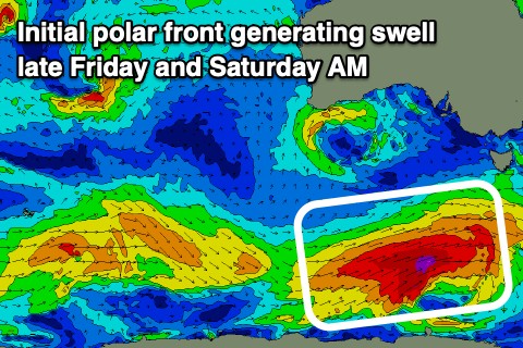
Currently a strengthening polar front is developing south of WA, with a fetch of strengthening gale to severe-gale W/SW winds due to project east-northeast through our southern swell window today before moving out of our swell window tomorrow morning.
This should produce a moderate sized S/SW groundswell, building late Friday to 3ft+ on the Surf Coast, 4-5ft to the east, peaking Saturday morning to 4ft on the sets across the Surf Coast and 6ft to the east (possibly odd bigger cleanup).
Winds in the wake of Friday's change will back off into Saturday, only moderate from the SW-S/SW, with the chance of an early W'ly on the Surf Coast.
Sunday looks similar in regards to local winds and conditions as a new larger long-period SW groundswell fills in.
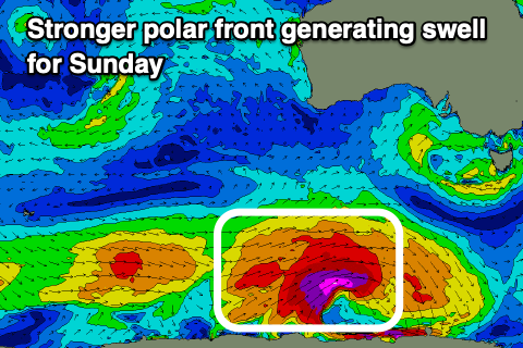 This stronger groundswell will be generated by a broader and and stronger polar low firing up south-southwest of WA tomorrow morning, generating a great fetch of severe-gale to storm-force W/SW winds through our south-western and then southern swell windows.
The groundswell will arrive early morning and should build to a strong 5-6ft on the sets across the Surf Coast, sets to 8ft on the Mornington Peninsula with morning SW-S/SW winds, tending fresh S/SE into the afternoon.
Unfortunately as talked about the last few updates, with the Long Wave Trough moving east and past us, all this frontal and swell activity will be met with onshore winds, S/SW into Monday as Sunday's swell starts to ease, with slightly smaller follow up S/SW swells Tuesday and Wednesday with S/SW winds.
There's the chance for lighter W winds Wednesday morning, but we'll have a closer look at this Friday.