Poor weekend, improving into next week for the beaches

Victoria Forecast by Craig Brokensha (issued Wednesday 11th March)
Best Days: Now ahead of the change, Monday from mid-morning on the beaches, Tuesday
Recap
Great conditions all day for the beaches with a good new groundswell to 4ft on the exposed beaches, 2ft+ on the Surf Coast though kicking a little more into the afternoon.
Today we've got another great morning of waves across most breaks with a bit more size reaching 3ft on the Surf Coast and hanging around 4ft to the east, but a new SW groundswell has since kicked further in size with conditions still nice and clean. We've got 3-4ft waves on the Surf Coast and 5-6ft sets to the east with an onshore change on the way, due mid-afternoon on the Surf Coast, a touch later to the east.

This weekend and next week (Mar 14 - 20)
Once this afternoon's change hits it'll be all over red rover for the weekend ahead.
Today’s building SW groundswell will start easing and strong onshore S'ly winds will kick up a poor windswell with choppy and messy waves to 3ft+ on the Surf Coast and 5-6ft on the Mornington Peninsula.
 Sunday now looks poor with winds not expected to swing E/SE any more and continue out of the SE-S/SE.
Moving into next week though we'll see conditions improve along with a good mix of building SW swells, a mix of mid-period energy and stronger groundswell.
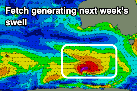
These swells will be generated by a flurry of polar frontal activity along the polar shelf today and tomorrow, with an initial fetch of strong W/NW winds due to be followed closely behind by stronger W/NW gales as a low forms.
The fast eastward track of this progression isn't ideal but we should still see a good kick in size for exposed breaks through Monday (afternoon), easing Tuesday.
Size wise we should see the Surf Coast build to 3ft+ through the day, 4-5ft on the Mornington Peninsula (smaller early) with winds swinging from E/SE-E early to E/NE through the morning, possibly even variable N/NE early afternoon ahead of late sea breezes.
Tuesday looks great all day with offshore N/NE tending NE winds as the swell eases from 3ft and 4ft+ respectively on the sets.
We'll see the swell continuing to fade into Wednesday with stronger morning N'ly winds.
Moving into the end of the week and it looks like we'll see a series of back to back polar fronts strengthening through our south-western and southern swell windows from mid-late next week and into next weekend – under the influence of a strengthening node of the Long Wave Trough.
At this stage with the node forming east of us it looks like winds won't be favourable, and more onshore than offshore, but more on this Monday. Make the most of the current surf and have a great weekend!