Average for the coming days, improving late week

Victoria Forecast by Craig Brokensha (issued Monday 3rd January)
Best Days: Selected spots Thursday morning, Friday morning
Recap
There was still a clean 1-2ft wave on the exposed beaches Saturday morning for the super keen ahead of an onshore change, clean on the Surf Coast yesterday morning but tiny.
Today a mix of mid-period W/SW and SW swells are filling in, clean early on the Surf Coast and to 2-3ft, but now deteriorating, poor and sizey to the east. We should see the swell peaking during the day to a stronger and more consistent 3ft+ on the Surf Coast, 4-5ft+ to the east but winds will remain onshore.
This week and weekend (Feb 4 – 9)
Today's mix of W/SW and SW swells are expected to ease back through tomorrow and conditions will be average with a moderate S/SE breeze as a strong high moves in from the west. Easing sets from 2-3ft are due on the Surf Coast, 4-5ft to the east. It won't be great but there'll be some grovelly beachy options.
Moving into Wednesday the swell will be smaller again as winds linger out of the S/SE, creating average conditions.
Thursday and Friday are now looking to be the pick of the period as we see a strong new S/SW groundswell fill in with more favourable E'ly winds develop across the beaches through the mornings.
The S/SW groundswell has been upgraded in size and power, with the polar low linked to it now generating winds in the gale to severe-gale range while pushing east and then east-northeast under Tassie while weakening over the coming days.
This will be ideally through our southern swell window, with the long-period energy due to arrive overnight Wednesday.
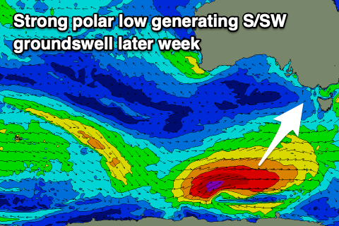 A moderate to large sized S/SW groundswell should be seen Thursday, coming in at 4-5ft on the Surf Coast and 6ft to possibly 8ft to the east, easing into the afternoon and down further Friday from 3ft+ and 4-5ft respectively.
Those winds on Thursday morning look to swing from a pre-dawn SE'ly to the E-E/SE through the morning, favouring selected spots, but with the size of the swell, options will be limited.
Friday morning looks better with the easing swell and more variable E/NE winds east of Melbourne, S'ly on the Surf Coast but only light. Winds will freshen from the S/SE into the afternoon but there should be plenty of time in the morning for one or two surfs.
From the weekend thinks will take a turn for the worse, with a deepening trough off the East Coast due to slowly deepen and shift southward, squeezing the strong high setting up camp south-west of us, resulting in persistent and strong E/SE winds from Saturday through at least Monday, if not longer. The models diverge on when this pattern may break down.
This will kick up messy and stormy levels of SE windswell through Bass Strait, while blocking our swell windows in the Southern Ocean. Therefore make the most of the surf later this week.