Good swell inbound, though winds are tricky, poor weekend

Victoria Forecast by Craig Brokensha (issued Monday 6th January)
Best Days: Selected spots Wednesday, selected beaches Thursday morning, exposed beaches Friday morning
Recap
Fun waves across the exposed beaches for the dawn session before an onshore change moved through Saturday morning, while yesterday the spike of swell from the 'bombing low' came in on forecast. Waves to 3ft+ were seen on the Surf Coast 5-6ft to the east with morning onshores tending more variable before freshening again.
This morning the swell is on the ease with lingering onshore winds, average and to 2-3ft on the Surf Coast and a better 3ft to the east.
This week and weekend (Jan 7 - 12)
Tomorrow will be poor as yesterday's spike in swell continues to ease along with onshore S/SE winds, moderate to fresh in strength.
We then look to the W/SW and SW groundswells due into Wednesday and Thursday.
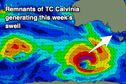 The source of these swells is the remnants of Tropical Cyclone Calvinia, with it moving in from the southern Indian Ocean and deepening south of WA yesterday. An initial fetch of pre-frontal W/NW gales should generate a small spike in W/SW groundswell late tomorrow, but a polar low forming yesterday has generated a fetch of W/SW gales in our south-western swell window.
This fetch has been slow moving and this will help generate a good pulse of SW groundswell which will last slightly longer than normal owing to the slow moving nature of the system.
The swell is due to fill in overnight Tuesday and peak Wednesday, reaching a fairly consistent 3ft across most breaks on the Surf Coast with 4ft sets on the swell magnets through the day, 5-6ft on the sets to the east.
Unfortunately winds will remain onshore and out of the S'th all day, limiting surfing options. Thursday looks better but not great with winds shifting E/SE-E through the morning favouring selected beaches as the swell eases slowly from 3ft+ and 4-5ft respectively on the sets west and east of Melbourne.
Friday morning will be clean across the beaches with an early and fresh N/NE breeze, shifting NW ahead of an afternoon W/SW change. The Surf Coast will be small and easing from 1-2ft, 2-3ft on the Mornington Peninsula.
The change later Friday will give into stronger S/SW winds on Saturday and an increase in windswell and building mid-period S/SW swell from a strengthening polar front moving west to east.
Size wise we're not looking at much over 3ft on the Surf Coast through Saturday, easing Sunday and 4-5ft+ to the east with winds remaining out of the S'th into Sunday. There'll also be a small and inconsistent W/SW swell in the mix on the weekend, but hard to distinguish under the closer-range S/SW swell.
Longer term it looks like onshore winds and average swells look to continue next week with limited options for a clean wave. More on this Wednesday though.