Poor weekend, improving later next week

Victoria Forecast by Craig Brokensha (issued Friday 3rd January)
Best Days: Selected spots Sunday morning, Thursday exposed beaches
Recap
A drop in swell back to 3ft on the sets across the Surf Coast yesterday, 4-5ft on the Mornington Peninsula with variable winds and fun conditions to the east, clean on the Surf Coast.
Today the swell is on the ease and winds from the east are favouring the exposed beaches.
This weekend and next week (Jan 4 - 10)
I hope you've made the most of the last few days of surf, because the outlook for the coming days is fairly poor.
Besides a dawn N'ly breeze tomorrow, conditions will be poor tomorrow with a strong W/SW tending S/SW change moving through soon thereafter. There'll be no real size left, tiny on the Surf Coast and to 2ft+ on the Mornington Peninsula.
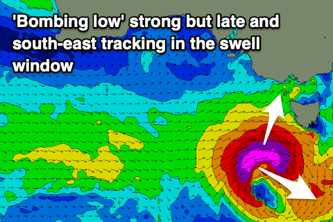 The spike of SW-S/SW swell from a 'bombing low' deepening south-west and south of the state this evening and tomorrow morning is still on the cards for Sunday, but so are the onshore winds. The low will track unfavourably to the south-east while generating a fetch of gale to severe-gale winds just in our swell window.
The size is a little tricky to forecast but we'll at least see a spike to 3ft+ on Sunday morning across the Surf Coast, 4-5ft to the east but with a moderate to fresh S'ly breeze, easing a touch into the afternoon and tending more S/SE.
The swell will ease rapidly into Monday but with average moderate E/SE-SE morning winds ahead of S/SE sea breezes. Tuesday looks void of any major swell and with lingering S/SE winds.
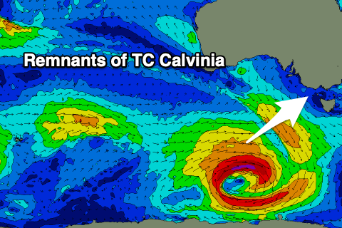 We then look towards the track and developments of Tropical Cyclone Calvinia from the east coast of Madagascar into the westerly storm track.
TC Calvinia is in the southern Indian Ocean and is expected to dip east-southeast and into our swell window on Sunday, with a pre-frontal fetch of W/NW gales being followed by a post-frontal fetch of gale to severe-gale W/SW winds as a low forms and stalls to the south of WA, near the polar shelf.
We should see an initial pulse of small W/SW groundswell Tuesday afternoon, ahead of the better SW groundswell Wednesday, peaking into the afternoon.
The Surf Coast should build to 3ft to possibly 4ft Wednesday afternoon, easing from 3ft+ Thursday morning with 5ft to possibly 6ft sets to the east Wednesday, 4-5ft on Thursday.
Conditions won't be too favourable Wednesday with E/SE tending S/SE breezes, better Thursday morning with a NE offshore. We'll have another look at this on Monday though. Have a great weekend!
Comments
Any update on Sunday's swell from the poorly tracking bombing low?