Last week is just a memory

Victoria Forecast by Craig Brokensha (issued Monday 9th December)
Best Days: Next Monday
Recap
Another pumping morning of waves across the Surf Coast Saturday with a reinforcing S/SW that arrived Friday afternoon, holding around 4-6ft, average to the east with the southerly swell direction. The swell was smaller and to 3ft on the Surf Coast Sunday but bumpy, better to the east with improving conditions and easing surf from a similar size under a morning variable breeze.
Today the swell has all but gone with tiny, clean waves across the exposed beaches, 1-2ft max on the Mornington Peninsula.
This week and weekend (Dec 10 - 15)
I hope you made the most of last week's great run of swell and conditions as we've got a very average period ahead.
The eastern arm of a large blocking high extending from us out into the Indian Ocean will put a block on our swell windows, resulting in no size and also persistent onshore winds through this week.
Tomorrow will start tiny, while a new SW swell from a short-lived and tight low is due into the afternoon. No major size is expected with the Surf Coast only likely to build to 2ft, with 3ft+ to the east but freshening onshore S/SW winds will create very average conditions.
 The swell will fade through Wednesday mixed in with a small, weak windswell along with moderate onshore S tending S/SW winds.
We may see a morning W/NW breeze on the Surf Coast Thursday morning, W/SW elsewhere but with no swell and tiny conditions.
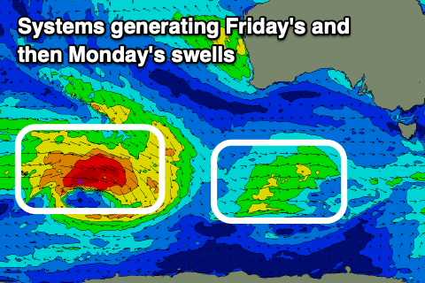
Winds will then strengthen from the SW through the day as a weak front clips the state. The swell potential from this system is poor with maybe a 2ft wave seen on the Surf Coast Friday, 3ft+ to the east but with pesky SW tending S/SW winds. We may see an early W'ly on the Surf Coast, but it'll be in no way worth putting in the diary.
Unfortunately the weekend outlook isn't much better with a morning W/NW Saturday wind but a drop in swell from Friday. Sunday remains poor with onshore SW winds and no change in the swell situation.
The only significant swell for the longer term is a very inconsistent W/SW groundswell for next Monday, generated by a distant and relatively innocuous storm developing north of Heard Island, moving east-southeast through our swell window. A good fetch of gale-force W/NW winds will be generated, but the distance between the storm and our state will result in a loss of size and consistency.
The swell may be seen late on Sunday but should peak through Monday to an inconsistent 3ft on the Surf Coast and 4-5ft to the east but with 5-10 minutes between sets. Winds look best for the Surf Coast and out of the W/NW through the morning ahead of S/SE sea breezes, but we'll have a closer look at this on Wednesday and Friday.
Comments
Wow
Just in case the last 10 days of onshores weren’t enough, here comes another 10. Hope you got a few 1fters this morning :-(