Generally average weekend, better next week

Victoria Forecast by Craig Brokensha (issued Friday 8th November)
Best Days: Keen surfers Surf Coast early tomorrow and Sunday, Monday, Wednesday Surf Coast, Thursday onwards Surf Coast
Recap
Morning high tides have affected the surf in protected spots yesterday and today, with a building mix of mid-period and groundswell from the W/SW yesterday, easing today and not as clean with an onshore change imminent on the Surf Coast.
This weekend and next week (Nov 9 - 15)
We've got weaker levels of mid-period W/SW tending SW swell due over the weekend across the state along with unfavourable winds.
The strongest of the swell has passed and now secondary weaker fronts moving in from the west and south-west will keep plenty of surf hitting the state, but you'll need to set your expectations low.
The size is expected to drop back a little tomorrow to 3ft+ on the Surf Coast swell magnets and 4-5ft to the east, while a secondary front moving up and into us through the day will likely provide a touch more size later afternoon.
Winds won't be too favourable, fresh and gusty out of the W/SW across most locations, but the Torquay region should see lighter and more favourable W-W/NW winds for a period tomorrow morning.
Sunday should see easing mid-period SW swell energy, back from 3ft+ on the Surf Coast swell magnets and 4-5ft+ to the east with similar fresh and gusty W/SW morning winds, shifting more SW-S/SW through the day.
Torquay may again see an early W'ly wind, but keep your expectations low.
Moving into Monday, and our improving and better conditions for the east are still on the cards with easing levels of mid-period SW swell.
Winds look offshore from the N/NW all day on the Surf Coast, but the Mornington Peninsula should see a dawn N/NW breeze, shifting more N'ly later morning and possibly N/NE later in the day. It'll swing back and forth at times and size wise we'll be looking at easing 2-3ft waves on the Surf Coast, 4ft or so to the east.
Looking at the outlook into the middle to end of the week, and the models have converged on the developments of a trough moving in from the west and we'll see this being a weak system, but attached to its base, a stronger low is forecast to form.
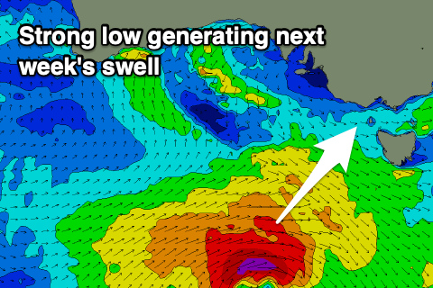 The low should generate a fetch of W/SW gales in our south-western swell window Sunday and Monday, weakening while broadening over Tasmania on Tuesday.
A moderate sized S/SW groundswell is expected from the low, filling in Tuesday and peaking into the afternoon. Unfortunately winds will be onshore and strong from the SW in the wake of the trough moving through early morning, but Wednesday should see a return to W/NW offshores as the swell eases.
Size wise, the Surf Coast should build to 3-4ft+, 6ft on the Mornington Peninsula and ease from 3-4ft and 5-6ft respectively Wednesday morning.
Follow up mid-latitude fronts will then keep moderate levels of W/SW swell hitting the state with westerly winds through the end of the week and into early next weekend, but we'll look at this closer on Monday. Have a great weekend!
Comments
for us poor souls in the east that forecast is as bad as it gets
Yep not your typical November. Owing again to a strong negative Southern Annular Mode, flowing on from the Sudden Stratospheric Warming event in late August.
Why cant there be a weak postive Northern Nonspherical Disorder that flows on from the Delayed Stratospheric Cooling event?
Haha, yeah it's called a HAWAII.
Hey Craig, how long will we continue too feel the effects of this unusual sudden warming event, will the entire summer be a writeoff here in Vicco?
Yes
Day after day after day of westerly wind.
Wtf is this?
Except today
Don't be so negative, Sam.
Very clever
Hahaha, nearly spat out my breakfast!