Stubborn high spoils swells

Victoria Forecast by Craig Brokensha (issued Monday 7th October)
Best Days: No real good days
Recap
Poor waves on Saturday with an inconsistent swell and onshore winds, better across the beaches early Sunday before winds became to strong and then gave into an onshore change. Sets to 3-4ft were seen across the exposed beaches, smaller on the Surf Coast.
Today a mix of mid-period swells are breaking and conditions are cleaner on the Surf Coast with sets to 2-3ft, 3-5ft to the east.
This week and weekend (Oct 8 - 13)
We've got plenty of swell this week, but the winds.. It's looking onshore from tomorrow morning and not really improving at all until the weekend.
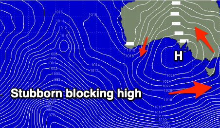 This will be related to a strong and stubborn high moving in from the west and sitting just south of Adelaide nearly all week, while a low forming in the Tasman Sea will squeeze its eastern flank and prevent it front shifting east until the weekend.
Swell wise, our new mid-period SW swell for tomorrow, generated by a polar front projecting up towards us us looking smaller and subsequently arriving later, but the secondary pulse of S/SW swell has been upgraded.
Tomorrow morning looks small and around 2ft on the Surf Coast, with the mid-period energy from the first front expected to build into the afternoon and reaching 3ft on the sets, 4ft+ to the east.
Unfortunately apart from a dawn W'ly breeze, winds will become strong from the S/SW mid-late morning creating poor conditions.
The swell should hold through Wednesday around 3ft and 4-5ft respectively across the Surf Coast and Mornington Peninsula and winds will be moderate to fresh from the S/SW-S leaving no quality surfing options.
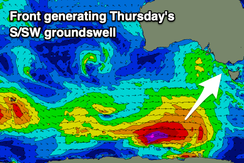 Into Thursday a good pulse of new S/SW groundswell is due, generated by a strong polar front that's currently developed south-southwest of WA.
This low is generating a fetch of gale-force W/SW winds and is expected to reach near storm-force at its core this afternoon and evening while pushing east through our southern swell window.
A moderate sized long-period S/SW groundswell should be seen, peaking Thursday morning to 4ft on the Surf Coast and 5-6ft to the east but winds will still be onshore and moderate in strength from the S/SW.
The swell is due to ease into the afternoon and back from 2ft+ on the Surf Coast Friday morning and 3ft to maybe 4ft to the east, but with SE-S/SE winds.
Come the weekend there'll be more SE windswell in the water than groundswell (owing to the blocking high across our main swell windows) with strong E/SE- SE winds due to develop through Bass Strait on Friday evening, and persisting through Saturday, possibly tending locally E/NE for a period east of Melbourne in the morning.
If so we'll be looking at a peaky mix of 2ft to maybe 3ft swell, bigger on the Surf Coast but a mess.
Sunday will finally see an offshore N/NE breeze kick in but with fading 1-2ft waves on the Mornington Peninsula, 2ft to the west.
Next week is looking more promising with a series of stronger polar fronts forecast to develop south-west of WA and push east through our swell windows, along with mid-latitude storms, bringing an increase in swell and also likely wind from Tuesday. More on this Friday though as the models are divergent regarding the mid-latitude activity.
Comments
Gary appreciates the hidden life advice in this forecast, Craig.
If Gary is picking up what you're putting down, you're advising the SN massive not to get too high or they'll have issues with generating enough swell in the southern regions?
Oh boy, it's so cold and miserable down here today, feels like we're back in the middle of winter but with only small dribbling surf. A great week to be at work ;)
Sudden Stratospheric Warming: report card so far C-
We've seen the Westerlies, yes, but a tad too much south in that westerly. Plenty of days where the wind will swing, go southerly, then SE as the high passes. Eventually it goes N and NE and Nick Bone gets some good waves. There has been swell, some head high days and some a bit bigger so the Southern Ocean still loves us.
But overall, there was hope the Sudden Stratospheric Warming would lead to lots of westerly in the WNW kind of direction. Instead we've had a bit more like you would expect during this change of seasons, wind speeds crank up and a few more onshore days. I wonder if the SAM (Southern Annular Mode I think is the correct one) is making the fronts too far south?
Many onshore sessions leads to C- score, room for improvement from SAM.
Yeah it hasn't truly filtered down yet and is slowly weakening. Might be just a weaker flow on effect now. SAM forecasts are still for a negative event, but not overly strong.
From a purely selfish P.O.V I hope it stays like this until early December due to being dry docked till then.....
I'm with you Ringmaster, but only until next week. My Balinese dog bite souvenir should be fully healed by then. Being told today my services are no longer required at work, I am looking forward to some mid-week surfs.