Generally average, mixed bag of waves

Victoria Forecast by Craig Brokensha (issued Wednesday 4th September)
Best Days: Beaches tomorrow, and early Friday, Surf Coast Sunday morning, Surf Coast Tuesday morning
Recap
Tiny waves on the Surf Coast yesterday, fun across the Mornington Peninsula during the morning before sea breezes kicked in.
Today a mix of new W/SW swells has started to fill in, offering better 2ft sets on the Surf Coast, 3-4ft on the Mornington Peninsula and nicely lined up. We should see the swell continue to build towards 2-3ft and 3-4ft+ respectively with a shallow S/SW change.
Today’s Forecaster Notes are brought to you by Rip Curl
This week and weekend (Sep 5 – 8)
Today's building mix of W/SW swells should hold into tomorrow morning, coming in at 2ft to occasionally 3ft on the Surf Coast magnets, and 3-4ft+ to the east, easing into the afternoon and further Friday.
The beaches are still looking the pick tomorrow morning with a NE offshore, swinging E/SE into the afternoon.
Friday morning should be clean across most spots with a light N/NW breeze, but small easing 1-2ft waves on the Surf Coast, 2ft to maybe 3ft to the east. Another S/SW change is due around midday, strengthening later in the day as a mid-latitude low moves in from the west.
Now that we're closer to this event, the models have converged and as expected, aligned with ECMWF, with the movement being slower rather than faster. We're also due to see a couple of secondary troughs/fronts pushing up and across us through the weekend and early next week, bringing a run of onshore winds and S/SW swells.
The low won't generate any major wind in through Bass Strait as it moves east, with Saturday seeing weak 2-3ft waves on the Surf Coast, 4ft+ to the east. Winds will be fresh but easing from the SW tending W/SW, possibly W'ly early around Torquay but this is a mute point.
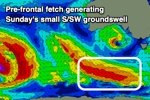 A new S/SW groundswell is due later in the day and more so Sunday, produced by an elongated fetch of pre-frontal W/NW gales developing along the polar shelf, south of the country tomorrow.
The fetch isn't ideally aligned and the Surf Coast only looks to come in around 2ft+, 3ft to occasionally to the east and with a NW tending W/NW breeze.
The secondary frontal systems will generate stronger SW gales up and into us through Sunday afternoon and evening, followed by a third front Monday, kicking up building levels of close-range S/SW swell.
The Surf Coast looks to reach a stormy 4-5ft through Monday afternoon but with strong SW tending S/SW winds, 6ft+ to the east.
Tuesday will become much cleaner as a high moves in, swinging winds around to the W/NW through the morning with easing surf from 4ft and 5-6ft respectively at this stage. ECMWF has an even stronger follow up polar front moving through our southern swell window, producing a good S/SW groundswell for Tuesday afternoon, but we'll have to have a closer look at this Friday.
Longer term there's still nothing too significant on the cards with mixed weak swells from the south and west, but more on this Friday.
Comments
Is the weather about to hit us Fri-Mon similar to the 4 day stretch of multiple fronts we copped about a month ago which brought a whole lot of snow but no swell? If so I assume it's another occasion where the SAM has gone too negative to generate any meaningful swell in our swell window and rather just a lot of wind and cold air?
Similar though not as good. Yeah negative SAM doesn't always equal good swell generating systems for Vicco. Likely less so with the storm track further north resulting in more westerly swells.