Tricky winds and swells, but large from the south Sunday

Victoria Forecast by Craig Brokensha (issued Wednesday 7th August)
Best Days: Surf Coast tomorrow morning, protected spots on the Surf Coast Friday, late Saturday Surf Coast, super protected spots Sunday, Surf Coast Tuesday
Recap
A small to tiny and easing swell yesterday, cleanest on the Surf Coast and a bit too windy to the east.
This morning we've got a building mid-period W/SW tending SW swell, only 1-2ft on the Surf Coast and 2-3ft on the Mornington Peninsula but we should see sets reaching 3ft and 4-5ft respectively through the day. Cape Sorell has risen nicely so keep an eye on developments. Winds are also forecast to go variable from the north opening up plenty of fun options.
Today’s Forecaster Notes are brought to you by Rip Curl
This week and weekend (Aug 8 - 11)
The late forming mid-latitude low linked to today's pulse of mid-period swell is now moving across Tasmania, and we'll see the swell dropping through tomorrow. The Surf Coast should see 2-3ft sets early, 4ft or so to the east though a gusty W/NW wind will only favour protected spots.
Our new inconsistent W/SW groundswell for Friday is still on track, generated by a strong and slow moving frontal progression through the southern Indian Ocean since late last week. Inconsistent but good 3ft sets are due across the Surf Coast with 4-5ft+ sets to the east, but what's worth pointing out is an incorrect spike in swell for the AM.
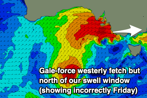 The models are picking up a big jump in W'ly swell which won't get into Bass Strait, with it generated north of our swell window and blocked by Cape Otway as shown in the image right. The latest updates have a small burst of gales pushing through Bass Strait Friday morning, but this likely won't produce any additional size on top the groundswell.
Looking at the local winds and it's tricky as the trough pushes through Friday morning, bringing strong W/SW-W winds, but the Surf Coast will likely see winds tending W/NW at periods through the day (not ideal).
In the wake of Friday's front we're due to see a strengthening polar front project up from the south-southwest on Saturday, with strong S/SW winds right off Tasmania's West Coast due to strengthen to severe-gale-force as the front pushes up and into us Saturday afternoon and evening.
We'll likely see a mix of swells around 3ft, kicking very late in the day. Winds will change through the day with a morning and strong SW breeze due to tend W'ly later in the afternoon as the front pushes up closer to us.
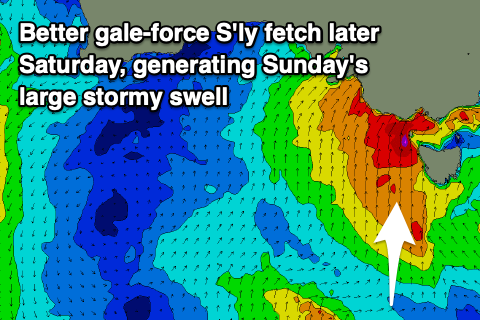 Sunday will reveal all the size though with a mix of groundswell and mid-period S/SW swell coming in at stormy 6ft on the Surf Coast and 6-8ft on the Mornington Peninsula with strong S/SW winds.
The swell is expected to start easing into the afternoon, but steady Monday as another less favourably and weaker polar front pushes up and into Tasmania on Sunday and early Monday.
This will keep conditions average to poor with a fresh and gusty SW'ly along with moderate levels of mid-period S/SW swell.
From Tuesday the wind and weather will start to improve as a high moves in from the west, swinging winds W/NW on the Surf Coast with easing 3-4ft sets out of the S/SW and 6ft waves to the east.
This high will block our close-range swell windows, resulting in the swell dropping through the rest of the week as winds shift more N'ly ahead of a possibly change Friday. A new inconsistent W/SW groundswell is expected into Thursday afternoon and Friday, produced by a slow moving low in the southern Indian Ocean. Whether winds hold from the north by the time the swell arrives is to be seen.
Comments
How big do you think it will be on the surfcoast friday craigos?
It's there above, the inconsistent W/SW groundswell.
Ah yep, that slipped me craigos. Thanks! Nothing worth putting down the glass bbq for on friday by the looks, kick off the weekend early
@tubbabird just look through your crystal glass fortune telling barbecue and pray
That’s it mate. We have to just sit tight with jet lighters in hand and wait for the right forey, while the rich Melbourne ‘surf’ pricks go skiing. We know who has it sweeter at the end of the day though!
Ball park of 15cm of snow each day fri through to sun for Vic alpine region....?????????
Having a quick look, from when it goes proper cold Thursday morning through into Friday morning it looks to be 40cm or so and then drying up through the day and into Saturday with another 5cm+ or so. Likely another top up Saturday afternoon/evening around 5-10cm or so.
yea wow! cheers for your thoughts much appreciated. :)
Getting stuck in?
Yes for sure. I have not been yet this year just waiting patiently like I do every year. Should be good.
I like your style!
How'd ya go? Looked so epic if you could get up there!
Yew I'll be up in the slopes Saturday and Sunday. I've got a whole new setup ready to go and the snow should be insane. What a couple of crazy weather systems.. love this weather!!
Satview is quite something to look at.. how's that system on the way to the South East in South Australia! http://satview.bom.gov.au/
Unreal!
You score as well?
Hey Craig surf looking pretty average for surf coast next thurs/fri?
Down in geelong to hang with a mate and was hoping to get a few days good waves!
Yeah, windy offshore but smallish and inconsistent waves in the 2-3ft range.
Ah balls thats no good. Better bring the groveller down. Lucky im hitting perisher next Sunday then !
Even better!
Air temps of 7.6°C at Cape Otway right now, and with 43kts of SW wind gusting 62kts (115km/hr) a short time ago, the wind chill factor means that it 'feels like' -8.5°C.
Barometer got down to 984hPa too, which means a 30cm rise in sea level above normal tides (plus a further increase associated with wind-driven storm surge).
Barometer went even lower further west, reaching 982.7hPa at Port Fairy and Portland, and 982.0 at Cape Nelson.
Hi Ben,
You say that there is a 30cm rise in sea level due to barometric pressure decreasing, this is the 1st time I've ever heard of this.
How is this caused and does an equivalent high pressure cause a decrease in level compared to normal tides?
Yeah it does, more here CB.. The Inverse Barometer Effect
Thanks Craig, that's an interesting read.
Mmm loving the earthnullschool patterns today. Couple typhoons near japan look amazing!
Wild day here today. Trees down everywhere and rain bucketing down sideways
Where are you goofball?
Just warming up the stihl !
Gods country
Tarneit???