Plenty of surf options this period, large and powerful next week

Victorian Forecast by Craig Brokensha (issued Friday 19th July)
Best Days: Beaches tomorrow, Surf Coast late Sunday, beaches Monday morning, protected spots from Tuesday through Thursday
Recap
Our new mid-period swell came in a bit above expectations yesterday morning with good and consistent 3-4ft waves on the Surf Coast, bumpy and 5-6ft to the east, though improving late as winds tended N'ly.
The swell has eased back a touch into this morning and conditions are great on the Surf Coast again, and bumpy to the east. A new W/SW groundswell is due to build through the day and we should see sets pushing more towards a consistent 3-4ft on the Surf Coast and 4-6ft on the Mornington Peninsula as winds tend more variable from the N’th across the peninsula.
Today’s Forecaster Notes are brought to you by Rip Curl
This weekend and next week (Jul 20 - 26)
These notes will be short as Ben's on annual leave.
This afternoon’s increase in W/SW groundswell is due to peak overnight, easing slowly through the day tomorrow as winds shift to the N/NE and strengthen through the morning. It’ll be tricky at times, but the exposed beaches are the pick with easing sets from 5-6ft, poor on the Surf Coast reefs with easing 3ft to likely 4ft sets.
Sunday morning will be smaller again, but our short-lived spike of W’ly swell is still on the cards for the afternoon, generated by a very intense but south-east tracking low through our swell window Sunday morning.
With the timing of the low, a late kick in size is due Sunday, likely to 3ft on the Surf Coast and 4-6ft on the Mornington Peninsula under early N/NW tending W/NW winds.
Come Monday the swell will be much smaller, dropping from 2ft on the Surf Coast and 3-4ft to the east with strong N’ly winds, opening up more exposed locations again.
This strong N’ly wind will be ahead of a significant frontal progression moving in from the west, under the influence of the Long Wave Trough.
We’re expected to see a very significant fetch of severe-gale to storm-force W/NW and W/SW winds projected through our western swell window, south-west of WA on the weekend before the progression moves further east and under the country early next week.
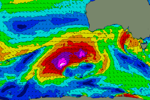 A large, and prolonged long-period W/SW groundswell event will be seen, building Tuesday and likely peaking later in the day/overnight, easing slowly Wednesday.
Size wise, the Surf Coast should build from around 4ft in the morning to 6ft by late, if not for the sneaky bigger one on the magnets. The Mornington Peninsula looks to build from 6ft to 8-10ft by dark and NW tending W/NW winds will favour protected locations all day.
The easing trend will be slowed as a great fetch of W/SW-SW gales remain in our swell window on Monday. A good reinforcing SW groundswell will likely be seen into the afternoon Wednesday ahead of another SW swell later week. With the frontal activity staying just to our west, conditions will remain great with a NW-W/NW breeze Wednesday, N/NW Thursday, but more on this Monday. Have a great weekend!
Comments
Sat being tricky due too wind strength or size?
Both
I didnt see the word ‘strengthen’ - just saw N/NE love heart eyes emoji
Nobody (and not even SN model) is forecasting N/NE, must be a mistake? N at best, if not N/NW. A day for the surf coast
Hi-res model has N/NE winds tomorrow morning, then tending more N through the day, likely N/NW on the Surf Coast, but mostly N.
Love your work