Good run of fun swell and clean waves on the Surf Coast

Victoria Forecast by Craig Brokensha (issued Monday 15th July)
Best Days: Surf Coast every morning over the coming period, and all day Thursday, Friday, Saturday and Sunday, locations to the east Saturday morning
Recap
Large and wind affected surf across the coast on Saturday, best in protected spots across both regions, while the Surf Coast cleaned up a little further Sunday offering fun waves on the protected reefs.
A new SW swell started to kick into the afternoon and has peaked this morning though with generally average to poor conditions across the state with fresh W/SW-SW winds.
Today’s Forecaster Notes are brought to you by Rip Curl
This week and weekend (Jul 16 - 21)
These notes will be short as Ben's on annual leave.
The coming week will see plenty of size with the Surf Coast offering the cleanest and best waves.
Today's large SW groundswell will be reinforced by a longer-period signal though with less size (generated by the initial stages of the strong low south-west of WA), and a new mid-period SW swell from a front pushing up and across Tassie today.
The surf may be a little muddled at times with three swells in the water and surf between 4-5ft, with 6ft bombs on the Surf Coast magnets, 6-8ft on the Mornington Peninsula. Winds will be best for protected spots, W/NW around Torquay in the morning and then generally W/SW.
 The swell will ease off into Wednesday from the 4ft range on the Surf Coast, and 6ft to the east, while another weak front moving up and into us through the afternoon and evening will keep the swell up just a little longer into Thursday. Conditions should be clean most of the day on Wednesday with a fresh W/NW breeze, shifting W/SW mid-late afternoon, while Thursday will be great all day with a persistent fresh NW offshore and easing 3-4ft sets on the Surf Coast (though mid-period energy), bumpy 5-6ft waves to the east.
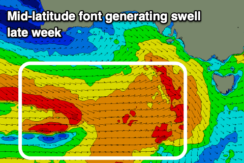
Moving into Friday a new W/SW groundswell is expected to fill in and peak Saturday morning, produced by a good mid-latitude frontal progression pushing in under the country mid-late week.
A broad fetch of strong to gale-force W/SW winds will be projected towards us, with a small embedded low producing an additional burst of W/SW gales south-west of us Friday morning.
This should produce a new W/SW Friday, kicking back to 3ft+ on the Surf Coast and 5-6ft on the Mornington Peninsula, with Saturday morning likely showing a little more consistent size, easing from 3-4ft and 6ft respectively.
Persistent W/NW tending NW winds will favour the Surf Coast all day Friday, great also Saturday with a fresh N/NW breeze. The Mornington Peninsula will offer clean conditions as well with winds N'ly through the morning on Saturday.
Following this the surf looks to ease into Sunday and Monday ahead of a possible large increase in swell mid-next week. More on this Wednesday though.