Building surf into the end of the week and weekend

Victoria Forecast by Craig Brokensha (issued Monday 8th July)
Best Days: Surf Coast Thursday, Friday, early Saturday, Sunday, Monday
Recap
Fun smallish waves on the exposed beaches Saturday to 2-3ft+ with great conditions, tiny on the Surf Coast, similar yesterday with an inconsistent long-range W/SW groundswell not amounting to much.
Today we've got a similar small to tiny mix of W/SW swells, clean on the Surf Coast but tiny and bumpy to the east.
Today’s Forecaster Notes are brought to you by Rip Curl
This week and weekend (Jul 9 - 14)
The coming couple of days will remain lay days with no significant swells and winds out of the NW tomorrow, gustier from the N/NW on Wednesday and possibly even tending N'ly later east of Melbourne.
A small and weak mid-period W/SW swell and very long-range W/SW groundswell signal may be seen into the afternoon, providing 2-3ft sets, but with the strong N'ly wind, conditions will be average.
We then look onwards to the developments into the end of the week and this weekend. A node of the Long Wave Trough will strengthen across the south-east of the country mid-late week pushing off across the Tasman Sea slowly on the weekend.
 This will project back to back and strengthening storms through our western swell window, producing building and strengthening levels of W/SW swell which at this stage looks to peak Saturday, likely followed by a secondary large SW groundswell early next week.
The first increases in size will be mostly mid-period energy and very west in nature, building Thursday from a small 2ft to maybe 3ft on the Surf Coast to 3-4ft into the late afternoon with persistent W/NW winds.
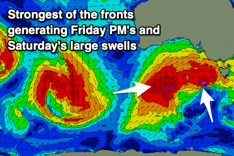
The strongest of the frontal systems will develop later this week, with an elongated fetch of severe-gale to storm-force W/SW-SW winds forecast to be projected towards us, on top an active sea state through our western swell window.
The swell should continue to build and strengthen Friday, reaching 4-6ft on the sets across the Surf Coast magnets into the afternoon, 6-8ft on the Mornington Peninsula.
Winds will remain out of the W/NW and with a bit of strength on Friday, shifting W/SW on Saturday though likely early W'ly around Torquay as the largest pulse of W/SW groundswell fills in.
We're looking at surf to 6 to maybe 8ft on the Surf Coast magnets and 8-10ft waves to the east along with those average winds, swinging back to the W/NW on Sunday as the swell eases.
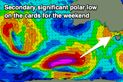 Monday's secondary large long-period SW groundswell will be generated by an intense polar low forming south-west of WA later this week, and tracking up on an arc towards Tasmania, following the LWT.
A fetch of storm-force W/SW tending SW winds are currently forecast to develop in our south-western swell window. We're looking at a larger and more SW directed groundswell, filling in Monday and peaking into the afternoon as winds persist out of the W, but more on this secondary swell and any changes to the weekend's swell on Wednesday.
Comments
Finally, some OMPH!
Hooray.