Head to the beaches as the swell eases

Victoria Forecast by Craig Brokensha (issued Wednesday 3rd July)
Best Days: Exposed beaches Friday, Saturday morning and Sunday
Recap
Great waves on the Surf Coast and selected spots to the east yesterday with a moderate to large sized W/SW groundswell and N/NW winds. The swell built further into the afternoon but with bumpier conditions as winds shifted W. The Surf Coast reached 4-6ft, a touch under expectations, while this morning is clean and easing from 4-5ft+. The exposed beaches to the east were still large and to 6-8ft, best in protected spots.
Today’s Forecaster Notes are brought to you by Rip Curl
This week and weekend (Jul 4 - 7)
The swell will drop over the coming days as winds swing to the east tomorrow, better out of the north-east on Friday.
The beaches will likely just be a bit too big tomorrow morning with 6ft sets, 3-4ft on the Surf Coast magnets but with that moderate E'ly wind, conditions will be bumpy and very average.
Friday should see winds go NE-N/NE through the morning as the swell drops back to 2-3ft on the Surf Coast and 4ft on the Mornington Peninsula, with the odd 5ft set in the mix. A new long-range W/SW groundswell is expected into the afternoon, but this will just steady the easing trend, with less consistent sets as winds tend E/NE. Hit the morning for the most consistent size and cleanest conditions.
Come the weekend the swell will continue to fade, easing from a small and inconsistent 2ft on the sets across the Surf Coast magnets and 3ft+ to the east with a fresher and persistent N/NE offshore.
Our very inconsistent long-range W/SW groundswell for Sunday mixed in with a closer-range W/SW swell into Monday are still on track, with the initial swell generated around Heard Island the last couple of days. A great but distant fetch of SW gales were projected towards Indonesia, with the storm currently weakening west-southwest of WA.
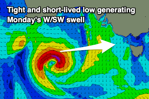 This swell will be very inconsistent, arriving later Saturday but peaking Sunday morning to 2ft on the sets across the Surf Coast magnets and 3ft to occasionally 4ft to the east. The remnants of the storm will form into a tight mid-latitude low under WA tomorrow evening, producing a very small fetch of W/SW gales in our western swell window. This doesn't look as favourable as it was on Monday and we'll likely just see a continuation of inconsistent 2ft sets on the Surf Coast magnets and 3-4ft sets to the east.
Winds will remain favourable for exposed breaks and be fresh from the N/NE most of the day Sunday, shifting N/NW later afternoon, and then average Monday with a SW change.
Longer term there's nothing too significant on the cards until late next week/weekend, so make the most of the coming cleaner days on the beaches.
Comments
You playing hard to get with the forey craig, you dirty dog you! Been hanging out for a taste all morning.
Haha, had it half written then, needed to hit Manly before the onshore winds kicked in. Enjoy.