Large W/SW groundswell inbound, cleaning up on the beaches as it eases

Victoria Forecast by Craig Brokensha (issued Monday 1st July)
Best Days: Surf Coast Tuesday, Wednesday morning, beaches to the east Friday and Saturday morning
Recap
Saturday's secondary pulse of inconsistent W/SW groundswell was just that. More west and very inconsistent but the magnets on the Surf Coast picked up the odd 3ft'er though winds were best for the beaches, and the Mornington Peninsula 4ft, with the rare 5ft set.
The swell dropped into Sunday morning, but a new mid-period W/SW swell built through the day as winds remained favourable for the Surf Coast.
This swell has held in a little stronger than expected this morning with the Surf Coast easing from 2-3ft this morning under fresh offshore winds, cleaner and 4-6ft to the east.
Today’s Forecaster Notes are brought to you by Rip Curl
This week and weekend (Jul 2 - 7)
Looking at the coming week and we've got a large and powerful long-period W/SW groundswell due to fill in tomorrow, peaking through the afternoon and then easing slowly into Wednesday.
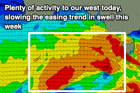 This swell begun being generated late last week by a vigorous and multi-staged frontal system that projected from the Heard Island region up towards and then under WA. The progression is now under the country to our west and still generating W'ly gales in our western swell window, with it continuing slowly east through this evening and tomorrow, weakening through the morning.
This will prolong the swell event, but size wise, there's been no real change since Friday, with the swell expected to fill in strongly tomorrow, reaching 6ft on the sets across Surf Coast swell magnets into the afternoon (if not for the odd bigger cleanup), and 8ft to occasionally 10ft on the Mornington Peninsula.
Winds look favourable for the Surf Coast and other protected spots most of the day with a morning NW breeze, shifting W/NW into the afternoon.
Wednesday should see a morning W/NW breeze again across the Surf Coast with weak onshore breezes across other locations, giving into sea breezes everywhere into the afternoon. Easing sets from 5-6ft are due on the Surf Coast swell magnets, and 8ft+ to the east, smaller into Thursday but with poor E/SE-E winds west of Melbourne.
The Mornington Peninsula should clean up as winds tend E/NE through the morning, but size wise, it'll still likely be a little too big for the beaches and easing from 6ft on the sets.
Friday looks much better with a persistent N/NE offshore and a better size for the beaches. A very inconsistent and long-range W/SW groundswell is due into the afternoon, generated by a fetch of pre-frontal W/NW gales just north-east of Heard Island this morning.
This will hopefully keep the Mornington Peninsula kicking at 3-5ft with 2-3ft sets on the Surf Coast, easing into Saturday from 3ft+ and 2ft respectively under a stronger N'ly offshore.
Longer term there's nothing too significant on the cards into Sunday or Monday as a large blocking high moves in from the west late week, bringing though northerly winds. A mid-latitude low forming from a trough early next week may generate a new W/SW swell for early next week, but we'll review this Wednesday.
Comments
Craig could you please elaborate a bit on expected surf size (surf coast) tomorrow morning before it peaks later in the afternoon?
Ah yes, as per the model guidance and likely 3-4ft on the magnets.