Mix of swells for the weekend (upgraded Sunday), large next week

Victoria Forecast by Craig Brokensha (issued Friday 28th June)
Best Days: Beaches Saturday (though windy and tricky at times), Surf Coast Sunday, Surf Coast experienced surfers Tuesday and Wednesday morning
Recap
A continuation of tiny 1-1.5ft waves on the Surf Coast yesterday, up to 2ft on the exposed beaches east of Melbourne.
Today our first pulse of small inconsistent W/SW groundswell has come in as expected, small and slow. The Surf Coast is seeing infrequent 2ft sets on the magnets with a gusty N'ly wind, while the exposed beaches to the east are offering better 3ft+ sets, though the wind is causing a few issues at some locations.
Today’s Forecaster Notes are brought to you by Rip Curl
This weekend and next week (Jun 29 – Jul 5)
Later today we may see our second slightly bigger but slightly more westerly angled groundswell filling in, but tomorrow is more reliable to see the extra size.
This swell provided XXL surf across Western Australia yesterday but was generated in our far western swell window. Therefore by the time it arrives on our coast we'll be looking at smaller and less consistent surf.
The Surf Coast magnets will hopefully offer very inconsistent 3ft sets (much smaller in between), with sets to 5ft on the Mornington Peninsula, though mostly 4-5ft. Winds will remain from a favourable direction but be strong and tricky at times, persisting from the N/NE most of the day now.
On dark a NW change is likely, and we've got an upgrade in the swell due on Sunday as a deep and intense low is now forecast to develop and push through Bass Strait early Sunday.
A quick burst of strong to gale-force W/SW winds will be projected through our swell window early Sunday morning, producing a building mid-period W/SW swell through Sunday, reaching 3ft to maybe 4ft on the Surf Coast by mid-late morning and 6ft on the Mornington Peninsula.
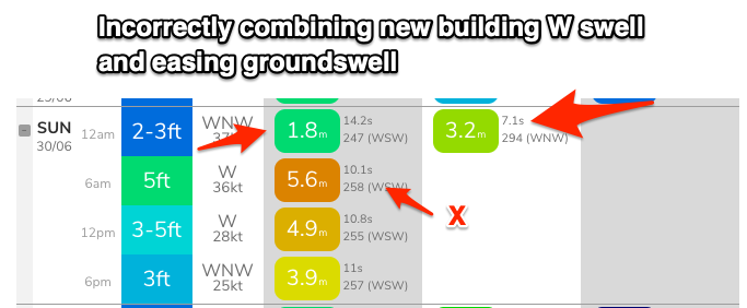 Our models are over forecasting this swell, with it incorrectly combining the easing W/SW groundswell and new mid-period swell.
Winds will be best for the Surf Coast and offshore from the W/NW all day, gusty at times and more NW later in the day.
The swell will ease rapidly into Monday with fading 2ft sets on the Surf Coast and 3ft to maybe 4ft waves to the east.
A fresh to strong N/NW wind will only favour the Surf Coast though.
We then look onwards to the large long-period W/SW groundswell due Tuesday/Wednesday on the coast.
The frontal progression linked to this swell has already started to develop in the Heard Island region. We're seeing a fetch of gale to severe-gale W/SW winds projected up towards Western Australia today, further towards the Bight over the weekend. This first front will be followed by a secondary system firing up right on its tail, projecting similar strength winds under WA's south coast Sunday. The progression will continue slowly east without losing much steam on Monday before pushing across Tasmania and clipping us Tuesday.
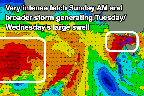 A large, long-period W/SW groundswell will be generated, building rapidly Tuesday and peaking into the afternoon to an easy 6ft on the Surf Coast magnets (if not for the odd bigger cleanup) and 8ft to occasionally 10ft on the Mornington Peninsula.
Winds will be offshore from the NW early Tuesday but with the passing frontal progression we'll see winds shift W/NW through the morning and then W/SW-SW mid-late afternoon. There should be plenty of time to get in a good clean wave as the swell builds though.
Wednesday should see a morning W/NW breeze on the Surf Coast again, SW into the afternoon as the large W/SW groundswell eases from 5-6ft on the Surf Coast and 8ft+ to the east.
Into the end of the week it looks like we'll see the swell continuing to ease as winds go anti-clockwise from S Thursday to NE on Friday owing to a strong high moving in. More on this Monday. Have a great weekend!